ملف:East-Hem 050ad.jpg

الملف الأصلي (3٬240 × 1٬903 بكسل حجم الملف: 722 كيلوبايت، نوع MIME: image/jpeg)
| هذا ملف من ويكيميديا كومنز. معلومات من صفحة وصفه مبينة في الأسفل. كومنز مستودع ملفات ميديا ذو رخصة حرة. |

|
هذه historical map الصورة / الصورتان باستعمال رسومات متجهية ملفات رسوميات شعاعية.
It is recommended to name the SVG file "East-Hem 050ad.svg" - then the template Vector version available (or Vva) does not need the new image name parameter.
|


ملخص
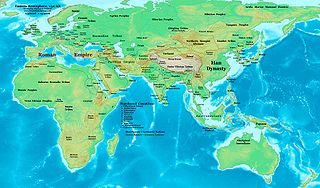
| الوصف | Eastern Hemisphere in 050 AD. |
| المصدر | عمل شخصي (For reference information, see the Map Source References section below.) |
| المؤلف | Thomas Lessman (Contact!) |
| الترخيص (إعادة استخدام هذا الملف) |
أنا، صاحب حقوق التأليف والنشر لهذا العمل، أنشر هذا العمل تحت الرخصة التالية: هذا الملفُّ مُرخَّص بموجب رخصة المشاع الإبداعي نسبة المُصنَّف إِلى مُؤَلِّفه - المشاركة بالمثل 3.0 العامة
|
| إصدارات أخرى | East-Hem_050ad.jpg file history on Wikipedia. |
Map Summary
Original Source URL: http://www.thomaslessman.com/History/images/East-Hem_050ad.jpg.
This map of the Eastern Hemisphere in 050 AD was created by Thomas Lessman, based on information from the sources listed below. This map is free for educational use (see Permission info above). When using this map, please mention that it is available for free at www.WorldHistoryMaps.info.
Map Source References
- Remember, sources often conflict with each other. This map is only as accurate as the information that is available to me. To report any errors or to help further this work, please click here, or email Thomas Lessman at talessman@yis.us
References for information contained in this map:
1. Borders of Europe are mostly derived from the www.Euratlas.com maps of Europe in 001 AD نسخة مؤرشفة at the Wayback Machine and from their map of Europe in 100 AD نسخة مؤرشفة at the Wayback Machine.
2. Borders of Asian countries are derive from the following sources:
- a - The DK Atlas of World History, 2000 Edition; map of The World in 1 CE, (Pages 42-43) was used for information on several Asian borders in this map.
- b - Korean borders derive from this map of Korea_001.png made by Wikipedia User:Historiographer.
3. Some info also derive from Wikimedia's map of the World_in_50_CE.
4. Much of the information in this map was cross-checked with Bruce Gordon's Regnal Chronologies.
Other Maps by Thomas Lessman
| Maps of the eastern hemisphere showing history
Bold dates are available on Wikimedia or Wikipedia. | ||
| Primeval | ||
| Ancient
|
·| 600 BC | 550 BC | 527 BC | 500 BC |
400 BC | ·| 1 AD | 50 AD | 100 AD | 200 AD | 300 AD | | |
| Medieval |
·| 500 AD | 565 AD | 600 AD | 700 AD | | |
| Modern |
·| 1500 AD | · * For historical maps of the whole world, | |
تاريخ الملف
اضغط على زمن/تاريخ لرؤية الملف كما بدا في هذا الزمن.
| زمن/تاريخ | صورة مصغرة | الأبعاد | مستخدم | تعليق | |
|---|---|---|---|---|---|
| حالي | 15:53، 9 مايو 2008 | | 3٬240 × 1٬903 (722 كيلوبايت) | Talessman | {{Information |Description=Eastern Hemisphere in 050 AD |Source=self-made |Author=Thomas Lessman |Permission={{self|cc-by-sa-3.0}} }} |
استخدام الملف
الصفحتان التاليتان تستخدمان هذا الملف:
الاستخدام العالمي للملف
الويكيات الأخرى التالية تستخدم هذا الملف:
- الاستخدام في bs.wikipedia.org
- الاستخدام في ca.wikipedia.org
- الاستخدام في en.wikipedia.org
- الاستخدام في es.wikipedia.org
- الاستخدام في fa.wikipedia.org
- الاستخدام في fr.wikipedia.org
- الاستخدام في gl.wikipedia.org
- الاستخدام في hu.wikipedia.org
- الاستخدام في inh.wikipedia.org
- الاستخدام في ja.wikipedia.org
- الاستخدام في mk.wikipedia.org
- الاستخدام في pl.wikipedia.org
- الاستخدام في pnb.wikipedia.org
- الاستخدام في ro.wikipedia.org
- الاستخدام في rue.wikipedia.org
- الاستخدام في ru.wikipedia.org
- الاستخدام في sh.wikipedia.org
- الاستخدام في simple.wikipedia.org
- الاستخدام في si.wikipedia.org
- الاستخدام في sv.wikipedia.org
- الاستخدام في sw.wikipedia.org
- الاستخدام في ta.wikipedia.org
- الاستخدام في tl.wikipedia.org
- الاستخدام في ur.wikipedia.org
- الاستخدام في vi.wikipedia.org
- الاستخدام في zh.wikipedia.org