ملف:DjoudjNASA.jpg
لا توجد دقة أعلى متوفرة.
DjoudjNASA.jpg (560 × 305 بكسل حجم الملف: 79 كيلوبايت، نوع MIME: image/jpeg)
| هذا ملف من ويكيميديا كومنز. معلومات من صفحة وصفه مبينة في الأسفل. كومنز مستودع ملفات ميديا ذو رخصة حرة. |
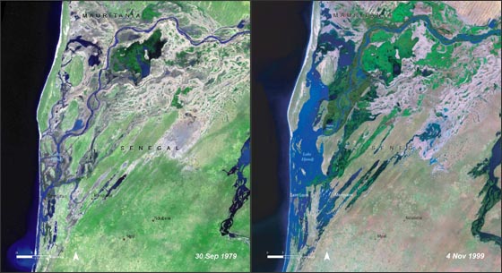
| الوصف | Lake Djoudj during the Sept. 1979 drought (left) and during the Nov. 1999 flood (right). http://landsat.gsfc.nasa.gov/images/archive/f0011.html In August 2006, the United Nations Environment Programme (UNEP), released an atlas entitled: "Africa's Lakes: Atlas of Our Changing Environment." The atlas relies heavily on Landsat imagery from the past 34 years to show changes in lakes around the African continent. Above, are two Landsat images of the Djoudj Sanctuary in Senegal that are featured in the atlas. The atlas tell us: "Situated in the Senegal river delta, the Djoudj Sanctuary is a wetland of 16 000 ha, comprising a large lake, referred to as Lake Djoudj in this publication, surrounded by streams, ponds and backwaters. These two images show the Djoudj Sanctuary before and after the construction of the Diama Dam." "The image from September 1979 shows the impact of drought on the Djoudj Sanctuary, while the image from November 1999 shows rejuvenation of the sanctuary wetlands due to the significant floods of that year. The two images vividly depict the impact of climate variability on the Djoudj Sanctuary—and demonstrate the broader need for close monitoring of the impacts of climate variability and climate change on lake environments." |
| التاريخ | August 2006 September 1979 November 1999 (٥ أكتوبر ٢٠٠٦ (وفقاً لبيانات تنسيق ملفِّ الصُّورة المُتبادَلة (Exif))) |
| المصدر | NASA [1] |
| المؤلف | غير معروف |
| يقع هذا العمل في النِّطاق العامّ في الولايات المُتحدة الأمريكيَّة لأَنَّه عملٌ خالِصٌ من إِنتاج وكالة الفضاء الأمريكيَّة. تنصُ حقوق التَّأليف والنَّشر الخاصَّة بوكالة الفضاء الأمريكيَّة على أنَّ "أعمال الوكالة غير مَحميَّة بحقوق التَّأليف والنَّشر ما لم يُذكر خلافُ ذلك". لمزيدٍ من المعلومات انظر القالِب {{PD-USGov}} وصفحة حقوق التَّأليف والنَّشر الخاصَّة بالوكالة وصفحة سياسة الصُّور الخاصَّة بمُختبر الدَّفع النَّفَّاث. | ||
 |
تنبيهات:
|
تاريخ الملف
اضغط على زمن/تاريخ لرؤية الملف كما بدا في هذا الزمن.
| زمن/تاريخ | صورة مصغرة | الأبعاد | مستخدم | تعليق | |
|---|---|---|---|---|---|
| حالي | 20:03، 16 أغسطس 2007 | | 560 × 305 (79 كيلوبايت) | Ji-Elle | Lake Djoudj during the Sept. 1979 drought (left) and during the Nov. 1999 flood (right). http://landsat.gsfc.nasa.gov/images/archive/f0011.html In August 2006, the United Nations Environment Programme (UNEP), released an atlas entitled: "Africa's Lakes: |
استخدام الملف
الصفحة التالية تستخدم هذا الملف:
الاستخدام العالمي للملف
الويكيات الأخرى التالية تستخدم هذا الملف:
- الاستخدام في az.wikipedia.org
- الاستخدام في ca.wikipedia.org
- الاستخدام في en.wikipedia.org
- الاستخدام في en.wikinews.org
- الاستخدام في fr.wikipedia.org
- الاستخدام في hy.wikipedia.org
- الاستخدام في mt.wikipedia.org
- الاستخدام في ru.wikipedia.org
- الاستخدام في ru.wikinews.org
- الاستخدام في www.wikidata.org