ملف:Dennis 2005-07-10 1615Z (alternate).jpg

الملف الأصلي (6٬800 × 8٬800 بكسل حجم الملف: 9٫37 ميجابايت، نوع MIME: image/jpeg)
| هذا ملف من ويكيميديا كومنز. معلومات من صفحة وصفه مبينة في الأسفل. كومنز مستودع ملفات ميديا ذو رخصة حرة. |
| تنبيه | تحذير: يمكن لبعض مُتصفحي الإِنترنت أن يواجهوا صعوباتٍ لدى عرض هذه الصُّورة بدقَّتها الكامِلة: لدى هذه الصُّورة عدد ضخم غير اعتيادي مِن النِّقاط، ومِن المُحتمل عدم تحميلها بشكل صحيحٍ في المُتصفِّح الذي قد يتوقف عن العمل نتيجة لذلك. عوضاً عن ذلك، مِن المُستحسن أن تضغط بزرّ الفأرة اليمين على وصلة دقة كاملة وتحفظها على جهازك. عندها يمكن اسخدام برامج خارجية لعرض وتعديل الصورة.
|
|---|
ملخص
| الوصف |
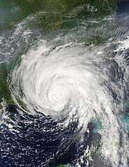
Hurricane Dennis was bearing down on the Gulf Coast of the United States on July 10, 2005, at 12:15 p.m. (16:15 UTC) when the Moderate Resolution Imaging Spectroradiometer on NASA's Terra satellite captured this image. With winds of 140 miles per hour (225 kph), Dennis was a powerful Category 4 storm just hours away from making landfall. At the time this image was taken, the eye of the storm was about 55 miles (90 kilometers) south, southeast of Pensacola, Florida, and the storm was moving northwest at about 18 miles per hour (29 kph). The size of the storm put clouds of rain over most of the southeastern United States well before the storm came ashore. In this image, Dennis covers all of Florida, Alabama, Mississippi, and stretches over parts of Louisiana. The northern fringes of the storm appear to be over Tennessee and North Carolina. For additional information and warnings about this storm, please visit the National Hurricane Center. This image is available in additional resolutions from the MODIS Rapid Response Team. |
|||||
| التاريخ | ||||||
| المصدر | http://earthobservatory.nasa.gov/NaturalHazards/natural_hazards_v2.php3?img_id=12947 | |||||
| المؤلف | NASA image courtesy Jacques Descloitres, MODIS Rapid Response Team, NASA GSFC | |||||
| الترخيص (إعادة استخدام هذا الملف) |
|
|||||
| إصدارات أخرى | Image:Hurricane Dennis 7102005.jpg |

.jpg)
تاريخ الملف
اضغط على زمن/تاريخ لرؤية الملف كما بدا في هذا الزمن.
| زمن/تاريخ | صورة مصغرة | الأبعاد | مستخدم | تعليق | |
|---|---|---|---|---|---|
| حالي | 01:20، 22 أكتوبر 2006 | | 6٬800 × 8٬800 (9٫37 ميجابايت) | Good kitty | == Summary == {{Information |Description=Hurricane Dennis was bearing down on the Gulf Coast of the United States on July 10, 2005, at 12:15 p.m. (16:15 UTC) when the Moderate Resolution Imaging Spectroradiometer on NASA's Terra satellite captured this im |
استخدام الملف
الصفحتان التاليتان تستخدمان هذا الملف:
الاستخدام العالمي للملف
الويكيات الأخرى التالية تستخدم هذا الملف:
- الاستخدام في ca.wikipedia.org
- الاستخدام في en.wikipedia.org
- Hurricane Dennis
- Timeline of the 2005 Atlantic hurricane season
- Portal:Cuba/Did you know
- Portal:Cuba/Did you know/9
- List of the wettest tropical cyclones in the United States
- Effects of Hurricane Dennis in Florida
- Effects of Hurricane Dennis in Alabama
- Effects of Hurricane Dennis in Georgia
- Effects of Hurricane Dennis in Mississippi
- Portal:Tropical cyclones/Featured article/Effects of Hurricane Dennis in Florida
- Template:Hurricane Dennis series
- List of natural disasters in Haiti
- Effects of Hurricane Dennis in Jamaica
- User:IPhonehurricane95/Picture of the day/Hurricane Dennis
- Meteorological history of Hurricane Dennis
- Effects of Hurricane Dennis in Haiti
- الاستخدام في es.wikipedia.org
- الاستخدام في eu.wikipedia.org
- الاستخدام في fr.wikipedia.org
- الاستخدام في ht.wikipedia.org
- الاستخدام في hu.wikipedia.org
- الاستخدام في no.wikipedia.org
- الاستخدام في pl.wikipedia.org
- الاستخدام في pt.wikipedia.org
- الاستخدام في ro.wikipedia.org
- الاستخدام في simple.wikipedia.org
- الاستخدام في sv.wikipedia.org
- الاستخدام في www.wikidata.org
- الاستخدام في zh.wikipedia.org
.jpg)