ملف:DeathValley L7 JuneJuly2000.jpg
حجم هذه المعاينة: 679 × 599 بكسل. الأبعاد الأخرى: 272 × 240 بكسل | 544 × 480 بكسل | 870 × 768 بكسل | 1٬160 × 1٬024 بكسل | 2٬318 × 2٬046 بكسل.
الملف الأصلي (2٬318 × 2٬046 بكسل حجم الملف: 3٫16 ميجابايت، نوع MIME: image/jpeg)
| هذا ملف من ويكيميديا كومنز. معلومات من صفحة وصفه مبينة في الأسفل. كومنز مستودع ملفات ميديا ذو رخصة حرة. |
ملخص
| الوصف |
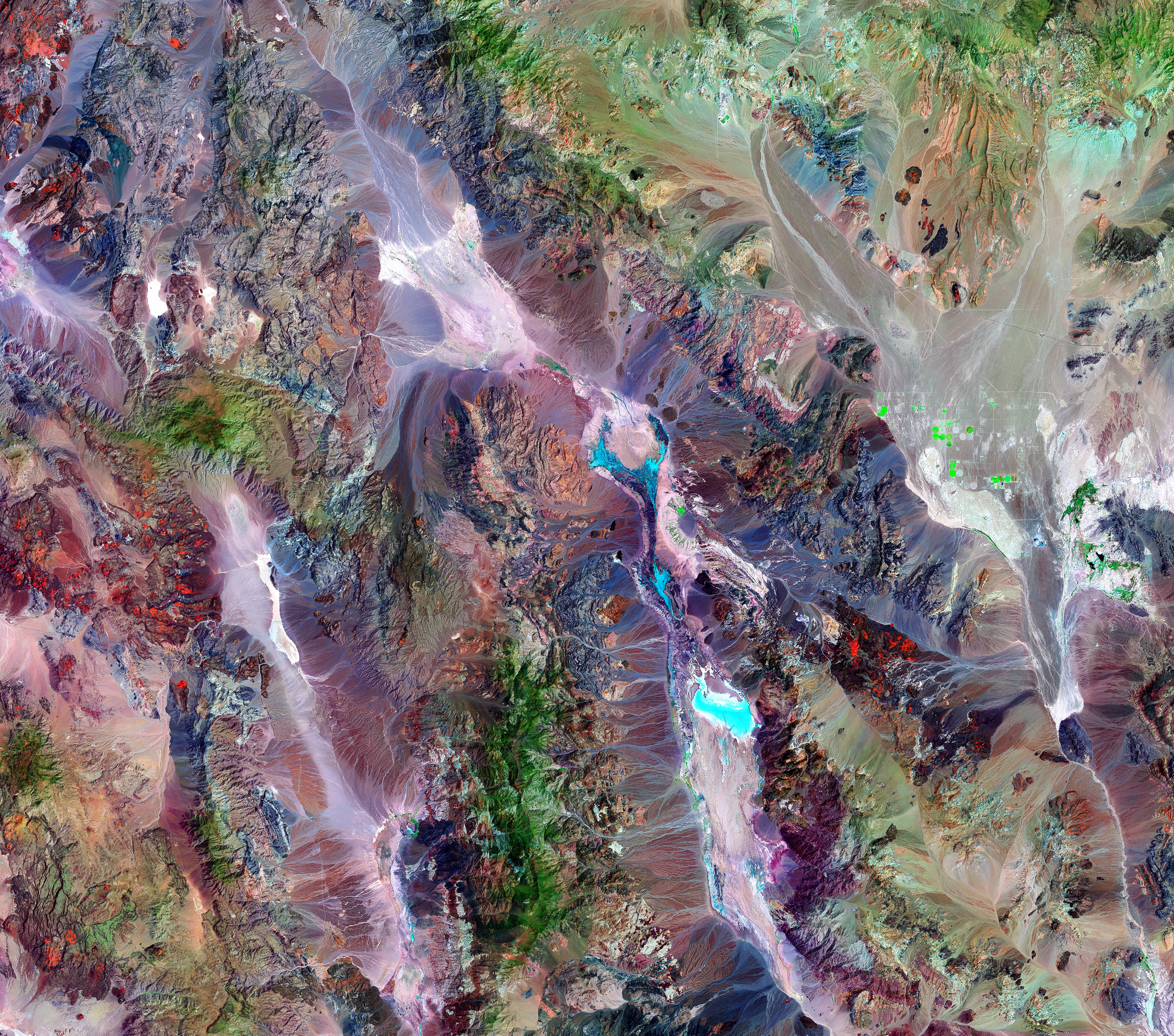
A thermal image compiled of two images taken by the Landsat 7 satellite of NASA. This image is of the Death Valley National Park's vegetation. As seen in the picture represented by the green coloring, the amount of vegetation increases as the altitude rises. Key- Green = Forest/Vegetation Rust/beige/brown = Bare ground Light blue = Salt pans with a little moisture Bright green = probably irrigation |
| التاريخ | يونيو ٠٠١١ and يوليو ٠٠٢٠, 2000 |
| المصدر | http://earthobservatory.nasa.gov/Newsroom/NewImages/images.php3?img_id=17247 |
| المؤلف | Landsat 7 satellite and Laura Rocchio, Landsat Project Science Office, using data provided courtesy of the Earth Satellite Corporation. |
| الترخيص (إعادة استخدام هذا الملف) |
US government, public domain |
| إصدارات أخرى | en:Image:Death valley vegetation aerial view.jpg |
ترخيص
| يقع هذا العمل في النِّطاق العامّ في الولايات المُتحدة الأمريكيَّة لأَنَّه عملٌ خالِصٌ من إِنتاج وكالة الفضاء الأمريكيَّة. تنصُ حقوق التَّأليف والنَّشر الخاصَّة بوكالة الفضاء الأمريكيَّة على أنَّ "أعمال الوكالة غير مَحميَّة بحقوق التَّأليف والنَّشر ما لم يُذكر خلافُ ذلك". لمزيدٍ من المعلومات انظر القالِب {{PD-USGov}} وصفحة حقوق التَّأليف والنَّشر الخاصَّة بالوكالة وصفحة سياسة الصُّور الخاصَّة بمُختبر الدَّفع النَّفَّاث. | ||
 |
تنبيهات:
|
تاريخ الملف
اضغط على زمن/تاريخ لرؤية الملف كما بدا في هذا الزمن.
| زمن/تاريخ | صورة مصغرة | الأبعاد | مستخدم | تعليق | |
|---|---|---|---|---|---|
| حالي | 17:08، 27 أبريل 2006 | | 2٬318 × 2٬046 (3٫16 ميجابايت) | Holly Cheng | {{Information | Description=Landsat 7 imagery of w:Death Valley, California, USA. Green indicates vegetation, which increases with altitude. The varying shades of brown, beige, and rust indicate bare ground; the different colors result from varying mi |
استخدام الملف
الصفحة التالية تستخدم هذا الملف:
الاستخدام العالمي للملف
الويكيات الأخرى التالية تستخدم هذا الملف:
- الاستخدام في en.wikipedia.org
- الاستخدام في sh.wikipedia.org
- الاستخدام في sr.wikipedia.org
- الاستخدام في ur.wikipedia.org