ملف:Daedelus comparison, remote sensing in precision farming.jpg
حجم هذه المعاينة: 366 × 598 بكسل. البعدان الآخران: 147 × 240 بكسل | 540 × 883 بكسل.
الملف الأصلي (540 × 883 بكسل حجم الملف: 143 كيلوبايت، نوع MIME: image/jpeg)
| هذا ملف من ويكيميديا كومنز. معلومات من صفحة وصفه مبينة في الأسفل. كومنز مستودع ملفات ميديا ذو رخصة حرة. |
| الوصف |
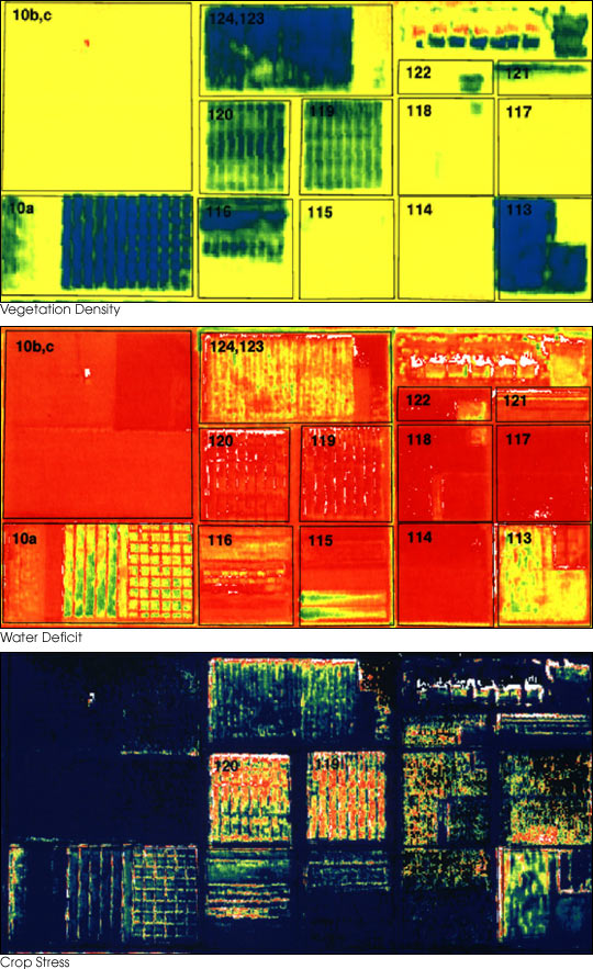
English: These three false-color images demonstrate some of the applications of remote sensing in precision farming. The goal of precision farming is to improve farmers’ profits and harvest yields while reducing the negative impacts of farming on the environment that come from over-application of chemicals. The images were acquired by the Daedalus sensor aboard a NASA aircraft flying over the Maricopa Agricultural Center in Arizona.
|
|||||
| التاريخ | قبل ٣٠ يناير ٢٠٠١ | |||||
| المصدر | earthobservatory.nasa.gov (NASA Earth Observatory, Image of the Day 2001-01-30 "Precision Farming") | |||||
| المؤلف | Susan Moran, Landsat 7 Science Team and USDA Agricultural Research Service (U.S. Government work) | |||||
| الترخيص (إعادة استخدام هذا الملف) |
|
|||||
| إصدارات أخرى |
.jpg) |

تاريخ الملف
اضغط على زمن/تاريخ لرؤية الملف كما بدا في هذا الزمن.
| زمن/تاريخ | صورة مصغرة | الأبعاد | مستخدم | تعليق | |
|---|---|---|---|---|---|
| حالي | 01:10، 28 يونيو 2010 | | 540 × 883 (143 كيلوبايت) | Bdk | {{Information |Description={{en|These three false-color images demonstrate some of the applications of remote sensing in precision farming. The goal of precision farming is to improve farmers’ profits and harvest yields whi |
استخدام الملف
الصفحة التالية تستخدم هذا الملف:
الاستخدام العالمي للملف
الويكيات الأخرى التالية تستخدم هذا الملف:
- الاستخدام في en.wikipedia.org
- الاستخدام في en.wikiversity.org
- الاستخدام في eu.wikipedia.org
- الاستخدام في fr.wikipedia.org
- الاستخدام في id.wikipedia.org
- الاستخدام في it.wikipedia.org
- الاستخدام في ja.wikipedia.org
- الاستخدام في ko.wikipedia.org
- الاستخدام في ms.wikipedia.org
- الاستخدام في oc.wikipedia.org
- الاستخدام في ru.wikipedia.org
- الاستخدام في ta.wikipedia.org
- الاستخدام في tr.wikipedia.org
- الاستخدام في uk.wikipedia.org
- الاستخدام في www.wikidata.org