ملف:Controlled airspaces.png

حجم هذه المعاينة: 800 × 291 بكسل. الأبعاد الأخرى: 320 × 116 بكسل | 640 × 233 بكسل | 1٬024 × 372 بكسل | 1٬280 × 465 بكسل | 2٬560 × 931 بكسل | 10٬826 × 3٬937 بكسل.
الملف الأصلي (10٬826 × 3٬937 بكسل حجم الملف: 1٫57 ميجابايت، نوع MIME: image/png)
| هذا ملف من ويكيميديا كومنز. معلومات من صفحة وصفه مبينة في الأسفل. كومنز مستودع ملفات ميديا ذو رخصة حرة. |
ملخص
| الوصف |
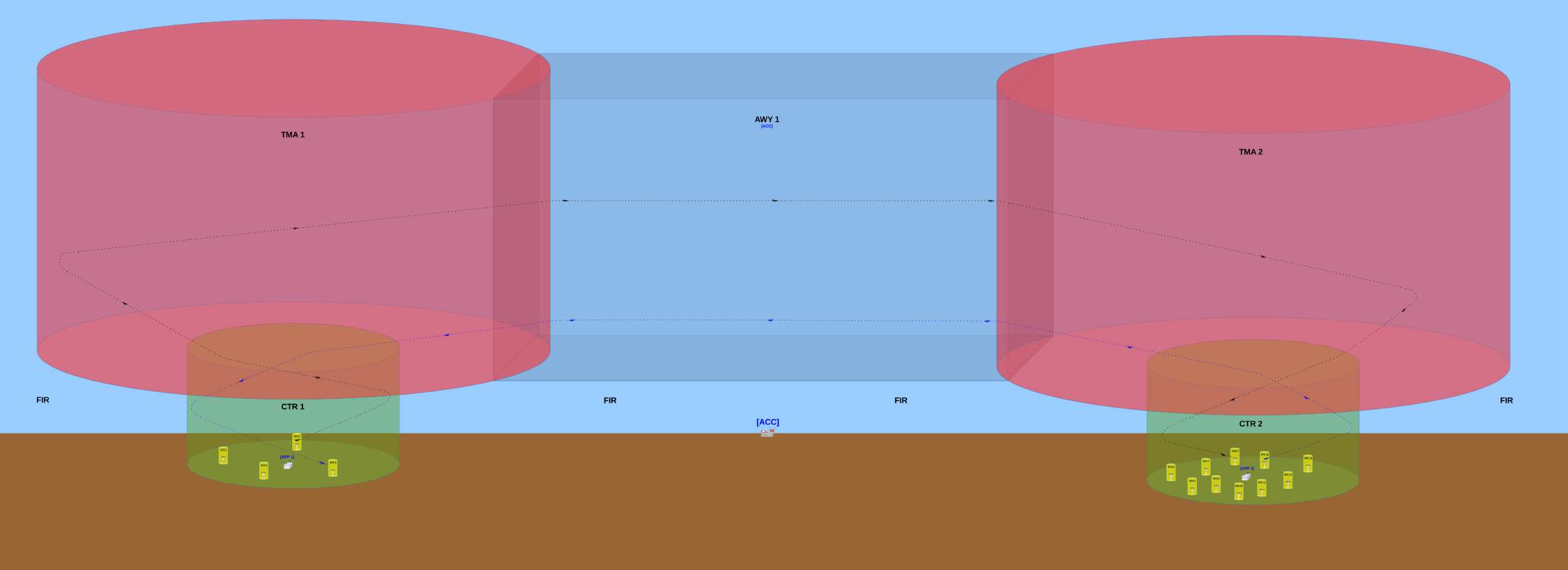
English: Basic configuration of the controlled airspaces and their respective air traffic control offices.
The TWR (aerodrome control tower) usually controls traffic that occurs inside the ATZ (aerodrome traffic zone) of the aerodrome where this TWR is installed at. The APP (approach control) usually controls traffic that occurs inside the CTR (control zone) but outside of the ATZs. The APP also controls traffic ocurring inside the TMA (terminal control area). The ACC (area control centre) usually controls traffic occurring inside any AWY (airway). In this image, the surrounding airspace (outside of the ATZs, CTRs, TMAs and AWY) is a non-controlled airspace designated a Flight Information Region (FIR). When an aircraft is flying into a FIR, no Air Traffic Control (ATC) office will provide any traffic control to this aircraft's pilot(s), however the ACC will provide it the Flight Information Service (FIS) and the Alerting Service (ALRS). Português: Configuração básica dos espaços aéreos controlados e seus respectivos órgãos de controle de tráfego aéreo.
A TWR (torre de controle de aeródromo) geralmente controla o tráfego que ocorre dentro da ATZ (Aerodrome Traffic Zone / Zona de Tráfego de Aeródromo) do aeródromo no qual essa TWR está instalada. O APP (Approach Control / Controle de Aproximação) geralmente controla o tráfego que ocorre dentro da CTR (Control Zone / Zona de Controle) mas que está fora das ATZ. O APP também controla o tráfego que ocorre dentro da TMA (Terminal Control Area / Área de Controle Terminal). O ACC (Area Control Centre / Centro de Controle de Área) geralmente controla o tráfego que ocorre dentro de qualquer AWY (Airway / Aerovia). Nesta imagem, o espaço aéreo ao redor (fora das ATZ, CTR, TMA e AWY) é um espaço aéreo não controlado denominado FIR (Flight Information Region / Região de Informação de Voo). Quando uma aeronave está voando dentro de uma FIR, nenhum órgão ATC (órgão de Air Traffic Control / Controle de Tráfego Aéreo) irá prover qualquer tipo de controle de tráfego para o(s) piloto(s) dessa aeronave, porém o ACC irá prover a esse(s) piloto(s) o FIS (Flight Information Service / Serviço de Informação de Voo) e o ALRS (Alerting Service / Serviço de Alerta). |
| التاريخ | |
| المصدر | عمل شخصي |
| المؤلف | Yuri Ribeiro Sucupira |
| الترخيص (إعادة استخدام هذا الملف) |
English: See license below. Attribution: when using this image, please provide a link to this page. As an alternative to providing a link, you can inform my full name (Yuri Ribeiro Sucupira) along with the license (see below). Português: Veja a licença abaixo. Atribuição: ao usar esta imagem, basta incluir uma ligação que aponte para esta página. Alternativamente, ao invés de fornecer um link você pode informar meu nome completo (Yuri Ribeiro Sucupira) juntamente com a licença (vide abaixo). |
| إصدارات أخرى |
English: The first version uploaded was quite different from the most up-to-date version and must not be used, mostly because it has a conceptual error: the inferior limit of the CTRs are above the Earth's surface, which is wrong because the inferior limit of a CTR must always be the Earth's surface. Português: A primeira versão incluída era consideravelmente diferente da versão mais atual deste desenho e não deve ser usada, principalmente porque essa primeira versão tem um erro conceitual: o limite inferior das duas CTR está acima do nível da superfície terrestre, mas isso está errado porque o limite inferior de uma CTR deve sempre ser a superfície terrestre. |
| موقع آلة التصوير | | هذه وغيرها من الصور في مواقعها على: خريطة الشارع المفتوحة |
|---|
ترخيص
أنا، صاحب حقوق التأليف والنشر لهذا العمل، أنشر هذا العمل تحت الرخصة التالية:
هذا الملفُّ مُرخَّص بموجب رخصة المشاع الإبداعي نسبة المُصنَّف إِلى مُؤَلِّفه - المشاركة بالمثل 3.0 العامة
- يحقُّ لك:
- مشاركة العمل – نسخ العمل وتوزيعه وبثُّه
- إعادة إنتاج العمل – تعديل العمل
- حسب الشروط التالية:
- نسب العمل إلى مُؤَلِّفه – يلزم نسب العمل إلى مُؤَلِّفه بشكل مناسب وتوفير رابط للرخصة وتحديد ما إذا أجريت تغييرات. بالإمكان القيام بذلك بأية طريقة معقولة، ولكن ليس بأية طريقة تشير إلى أن المرخِّص يوافقك على الاستعمال.
- الإلزام بترخيص المُشتقات بالمثل – إذا أعدت إنتاج المواد أو غيرت فيها، فيلزم أن تنشر مساهماتك المُشتقَّة عن الأصل تحت ترخيص الأصل نفسه أو تحت ترخيص مُتوافِقٍ معه.
تاريخ الملف
اضغط على زمن/تاريخ لرؤية الملف كما بدا في هذا الزمن.
| زمن/تاريخ | صورة مصغرة | الأبعاد | مستخدم | تعليق | |
|---|---|---|---|---|---|
| حالي | 21:39، 12 مارس 2014 | 10٬826 × 3٬937 (1٫57 ميجابايت) | Sampayu | Improvement: added some objects (airplanes and towers) that were missing mostly on the right side of the picture. | |
| 20:39، 11 مارس 2014 | 10٬568 × 3٬630 (1٫27 ميجابايت) | Sampayu | This new version has more detailed visual informations and the file size is smaller, which makes it more didactic and is good to help Wikipedia articles and internet pages in general load faster when they have this image embedded in them. The previou... | ||
| 09:15، 8 مارس 2014 | 3٬550 × 1٬185 (16٫07 ميجابايت) | Sampayu | User created page with UploadWizard |
استخدام الملف
الصفحة التالية تستخدم هذا الملف:
الاستخدام العالمي للملف
الويكيات الأخرى التالية تستخدم هذا الملف:
- الاستخدام في en.wikipedia.org
- الاستخدام في fa.wikipedia.org
- الاستخدام في id.wikipedia.org
- الاستخدام في pt.wikipedia.org