ملف:Cheshire outline map with UK.png
لا توجد دقة أعلى متوفرة.
Cheshire_outline_map_with_UK.png (722 × 552 بكسل حجم الملف: 412 كيلوبايت، نوع MIME: image/png)
| هذا ملف من ويكيميديا كومنز. معلومات من صفحة وصفه مبينة في الأسفل. كومنز مستودع ملفات ميديا ذو رخصة حرة. |
ملخص
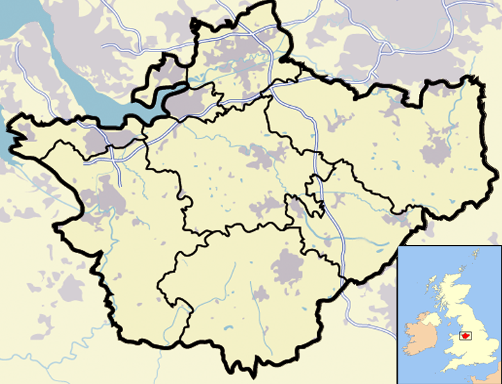
| الوصف | Map of en:Cheshire and surrounding area, with micromap of the British Isles for context. Urban areas are shown in grey, water bodies in light-blue, motorways in blue with white stripe and county and borough boundaries in black. |
| التاريخ | ٢٩ مارس ٢٠٠٧ (تاريخ الرفع الأصيل) |
| المصدر | نُقِلت من en.wikipedia إلى كُومُنز . |
| المؤلف | Jhamez84 في ويكيبيديا الإنجليزية |
| إصدارات أخرى |
.png) (for boundaries expected to come into effect for 2009). (for boundaries expected to come into effect for 2009). |
ترخيص
| وضع -Jhamez84 في ويكيبيديا الإنجليزية-، وهو المؤلف، هذا العمل في النِّطاق العامِّ. يسري ذلك في كل أرجاء العالم. في بعض البلدان، قد يكون هذا التَّرخيص غيرَ مُمكنٍ قانونيَّاً، في هذه الحالة: يمنح Jhamez84 الجميع حق استخدام هذا العمل لأي غرض دون أي شرط ما لم يفرض القانون شروطًا إضافية. |
سجلُّ الرَّفع الأصيل
صفحة الوصف الأصلية كانت هنا، تشير جميع أسماء المستخدمين التالية إلى en.wikipedia.
- 2007-04-11 23:50 Jhamez84 722×552×8 (421996 bytes) correcting positioning of some urban areas (they were too east-northeasterly)
- 2007-04-11 17:14 Jhamez84 722×552×8 (420187 bytes) fixing issues in and around the [[M6 motorway]] (moving it to the west per discussion)
- 2007-04-11 00:38 Jhamez84 722×552×8 (438177 bytes) Much more detailed (and thus hopefully more accurate) version of the [[Cheshire]] map.
- 2007-03-29 23:48 Jhamez84 800×558×8 (446798 bytes) Map of [[Cheshire]] and surrounding area, with micromap of the British Isles for context. Urban areas are shown in grey, water bodies in light-blue, motorways in blue with white stripe and county and borough boundaries in black.
تاريخ الملف
اضغط على زمن/تاريخ لرؤية الملف كما بدا في هذا الزمن.
| زمن/تاريخ | صورة مصغرة | الأبعاد | مستخدم | تعليق | |
|---|---|---|---|---|---|
| حالي | 13:02، 23 يونيو 2008 | | 722 × 552 (412 كيلوبايت) | Jza84 | removed erroneous urban area |
| 20:55، 29 يونيو 2007 |  | 722 × 552 (412 كيلوبايت) | Pit-yacker | {{Information |Description=Map of en:Cheshire and surrounding area, with micromap of the British Isles for context. Urban areas are shown in grey, water bodies in light-blue, motorways in blue with white stripe and county and borough boundaries in bl |
استخدام الملف
الصفحة التالية تستخدم هذا الملف:
الاستخدام العالمي للملف
الويكيات الأخرى التالية تستخدم هذا الملف:
- الاستخدام في ceb.wikipedia.org
- الاستخدام في en.wikipedia.org
- الاستخدام في eo.wikipedia.org
- الاستخدام في ga.wikipedia.org
- الاستخدام في ml.wikipedia.org
- الاستخدام في pt.wikipedia.org
- الاستخدام في ro.wikipedia.org
- الاستخدام في sv.wikipedia.org
- الاستخدام في tt.wikipedia.org
- الاستخدام في uk.wikipedia.org
- الاستخدام في www.wikidata.org