ملف:Bradgate park general map.png
لا توجد دقة أعلى متوفرة.
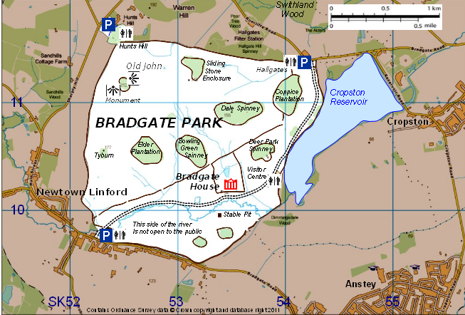
Bradgate_park_general_map.png (653 × 442 بكسل حجم الملف: 350 كيلوبايت، نوع MIME: image/png)
| هذا ملف من ويكيميديا كومنز. معلومات من صفحة وصفه مبينة في الأسفل. كومنز مستودع ملفات ميديا ذو رخصة حرة. |
ملخص
| الوصف |
English: Map of Bradgate Park, Leicestershire, England, showing its main topographical features |
| التاريخ | |
| المصدر | created by Robin Stevenson based on Ordnance Survey data © Crown copyright and database right 2011 available under OS Opendata, from OS Vectormap District raster map SK51, downloadable from https://www.ordnancesurvey.co.uk/opendatadownload/products.html |
| المؤلف | Robin Stevenson based on Ordnance Survey data © Crown copyright and database right 2011 under UK Open Government licence at http://www.nationalarchives.gov.uk/doc/open-government-licence/open-government-licence.htm |
ترخيص
هذا الملف مرخص بموجب أوردنانس سورفي من المملكة المتحدة تحت OS OpenData License. باختصار: أنت حر في توزيع الملف وتعديله طالما أنك تعزو أوردنانس سورفي.
نسب العمل لمُؤَلِّفه: Contains Ordnance Survey data © Crown copyright and database right (year) ملاحظة: يمكن ترخيص الأعمال المشتقة بموجب أي ترخيص مشاع إبداعي عزو 3.0. |
_(St_Edwards_Crown).svg)
|
This file is licensed under the United Kingdom Open Government Licence v3.0. |
See also: Meta for information on usage on Wikimedia wikis.
|
تاريخ الملف
اضغط على زمن/تاريخ لرؤية الملف كما بدا في هذا الزمن.
| زمن/تاريخ | صورة مصغرة | الأبعاد | مستخدم | تعليق | |
|---|---|---|---|---|---|
| حالي | 18:02، 27 يناير 2011 | | 653 × 442 (350 كيلوبايت) | RobinLeicester | {{Information |Description ={{en|1=Map of Bradgate Park, Leicestershire, England, showing its main topographical features}} |Source =created by Robin Stevenson based on Ordnance Survey data © Crown copyright and database right 2011 available u |
استخدام الملف
الصفحتان التاليتان تستخدمان هذا الملف:
الاستخدام العالمي للملف
الويكيات الأخرى التالية تستخدم هذا الملف:
- الاستخدام في en.wikipedia.org
- الاستخدام في pl.wikipedia.org
- الاستخدام في zh.wikipedia.org