ملف:Blue Marble 2002.png

الملف الأصلي (43٬200 × 21٬600 بكسل حجم الملف: 529٫58 ميجابايت، نوع MIME: image/png)
| هذا ملف من ويكيميديا كومنز. معلومات من صفحة وصفه مبينة في الأسفل. كومنز مستودع ملفات ميديا ذو رخصة حرة. |
| هذه صورة مختارة، وهذا يعني أن مجتمع ويكيبديا العربية اتفق على تصنيفها واحدة من أفضل الصور في ويكيبيديا العربية، وتضيف شيئاً هامّاً إلى مقالها. إذا كنت تملك صورة أخرى ذات جودة مشابهة، فلا تتردد في رفعها مستخدماً ترخيصاً حرّاً مناسباً، وإضافتها إلى مقال مناسب، ومن ثم ترشيحها. |
ملخص
| تنبيه | تحذير: يمكن لبعض مُتصفحي الإِنترنت أن يواجهوا صعوباتٍ لدى عرض هذه الصُّورة بدقَّتها الكامِلة: لدى هذه الصُّورة عدد ضخم غير اعتيادي مِن النِّقاط، ومِن المُحتمل عدم تحميلها بشكل صحيحٍ في المُتصفِّح الذي قد يتوقف عن العمل نتيجة لذلك. عوضاً عن ذلك، مِن المُستحسن أن تضغط بزرّ الفأرة اليمين على وصلة دقة كاملة وتحفظها على جهازك. عندها يمكن اسخدام برامج خارجية لعرض وتعديل الصورة.
|
|---|
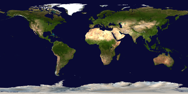
| الوصف |
العربية: صور ساتليَّة مُجمَّعة لتُظهر سطح الأرض كاملًا.
English: This spectacular “blue marble” image is the most detailed true-color image of the entire Earth to date. Using a collection of satellite-based observations, scientists and visualizers stitched together months of observations of the land surface, oceans, sea ice, and clouds into a seamless, true-color mosaic of every square kilometer (.386 square mile) of our planet. These images are freely available to educators, scientists, museums, and the public.
Much of the information contained in this image came from a single remote-sensing device-NASA’s Moderate Resolution Imaging Spectroradiometer, or MODIS. Flying over 700 km above the Earth onboard the Terra satellite, MODIS provides an integrated tool for observing a variety of terrestrial, oceanic, and atmospheric features of the Earth. The land and coastal ocean portions of these images are based on surface observations collected from June through September 2001 and combined, or composited, every eight days to compensate for clouds that might block the sensor’s view of the surface on any single day. Two different types of ocean data were used in these images: shallow water true color data, and global ocean color (or chlorophyll) data. Topographic shading is based on the GTOPO 30 elevation dataset compiled by the U.S. Geological Survey’s EROS Data Center. MODIS observations of polar sea ice were combined with observations of Antarctica made by the National Oceanic and Atmospheric Administration’s AVHRR sensor—the Advanced Very High Resolution Radiometer. The cloud image is a composite of two days of imagery collected in visible light wavelengths and a third day of thermal infra-red imagery over the poles. Global city lights, derived from 9 months of observations from the Defense Meteorological Satellite Program, are superimposed on a darkened land surface map. |
| التاريخ | |
| المصدر | NASA Visible Earth: Blue Marble: Land Surface, Shallow Water, and Shaded Topography |
| المؤلف | NASA’s Terra satellite for the MODIS imageries, combined by Meow. Credit: NASA Goddard Space Flight Center Image by Reto Stöckli (land surface, shallow water, clouds). Enhancements by Robert Simmon (ocean color, compositing, 3D globes, animation). Data and technical support: MODIS Land Group; MODIS Science Data Support Team; MODIS Atmosphere Group; MODIS Ocean Group Additional data: USGS EROS Data Center (topography); USGS Terrestrial Remote Sensing Flagstaff Field Center (Antarctica); Defense Meteorological Satellite Program (city lights). |
| إصدارات أخرى |
|
.png)


التقييم
|
ترخيص
| يقع هذا العمل في النِّطاق العامّ في الولايات المُتحدة الأمريكيَّة لأَنَّه عملٌ خالِصٌ من إِنتاج وكالة الفضاء الأمريكيَّة. تنصُ حقوق التَّأليف والنَّشر الخاصَّة بوكالة الفضاء الأمريكيَّة على أنَّ "أعمال الوكالة غير مَحميَّة بحقوق التَّأليف والنَّشر ما لم يُذكر خلافُ ذلك". لمزيدٍ من المعلومات انظر القالِب {{PD-USGov}} وصفحة حقوق التَّأليف والنَّشر الخاصَّة بالوكالة وصفحة سياسة الصُّور الخاصَّة بمُختبر الدَّفع النَّفَّاث. | ||
 |
تنبيهات:
|
تاريخ الملف
اضغط على زمن/تاريخ لرؤية الملف كما بدا في هذا الزمن.
| زمن/تاريخ | صورة مصغرة | الأبعاد | مستخدم | تعليق | |
|---|---|---|---|---|---|
| حالي | 10:34، 23 يوليو 2023 | | 43٬200 × 21٬600 (529٫58 ميجابايت) | Gioppolognomo | Reverted to version as of 11:53, 5 August 2016 (UTC) |
| 10:28، 23 يوليو 2023 |  | 5٬400 × 2٬700 (41٫8 ميجابايت) | Gioppolognomo | ||
| 11:53، 5 أغسطس 2016 |  | 43٬200 × 21٬600 (529٫58 ميجابايت) | Meow | c:User:Rillke/bigChunkedUpload.js: |
استخدام الملف
ال6 صفحات التالية تستخدم هذا الملف:
الاستخدام العالمي للملف
الويكيات الأخرى التالية تستخدم هذا الملف:
- الاستخدام في bcl.wikipedia.org
- الاستخدام في bn.wikipedia.org
- الاستخدام في en.wikipedia.org
- Earth observation satellite
- World map
- Equirectangular projection
- Wikipedia:Featured pictures thumbs/04
- User talk:Nnfolz
- Wikipedia:Featured pictures/Space/Looking back
- Talk:Fishing vessel
- User:Huggums537
- Template talk:GeoTemplate/Archive 15
- Wikipedia:Featured picture candidates/delist/2020
- Wikipedia:Featured picture candidates/delist/Blue Marble
- User:GTAVCV20022013
- User:Hurricane Noah/TCMap/Current
- User:Hurricane Noah/TCMap
- User:Hurricane Noah/TCMap/Maps
- User talk:HighInBC/Archive 83
- User:LoekVV
- Portal:World
- Wikipedia:Picture of the day/January 2023
- User:SuperPentagonAnimations/sandbox
- Wikipedia talk:WikiProject Weather/Colour discussions
- Template:POTD/2023-01-11
- Wikipedia:Main Page history/2023 January 11
- Wikipedia:Main Page history/2023 January 11b
- الاستخدام في en.wikibooks.org
- الاستخدام في fa.wikipedia.org
- الاستخدام في fr.wikipedia.org
- الاستخدام في ha.wikipedia.org
- الاستخدام في he.wikipedia.org
- الاستخدام في it.wikibooks.org
- الاستخدام في mk.wikipedia.org
- الاستخدام في pnb.wikipedia.org
- الاستخدام في th.wikipedia.org
- الاستخدام في tr.wikipedia.org
- الاستخدام في tum.wikipedia.org
- الاستخدام في tw.wikipedia.org
- الاستخدام في ur.wikipedia.org
- الاستخدام في vi.wikipedia.org