ملف:Arabian Peninsula arabic.png
حجم هذه المعاينة: 757 × 599 بكسل. الأبعاد الأخرى: 303 × 240 بكسل | 606 × 480 بكسل | 1٬018 × 806 بكسل.
الملف الأصلي (1٬018 × 806 بكسل حجم الملف: 394 كيلوبايت، نوع MIME: image/png)
| هذا ملف من ويكيميديا كومنز. معلومات من صفحة وصفه مبينة في الأسفل. كومنز مستودع ملفات ميديا ذو رخصة حرة. |
ملخص
| الوصف |
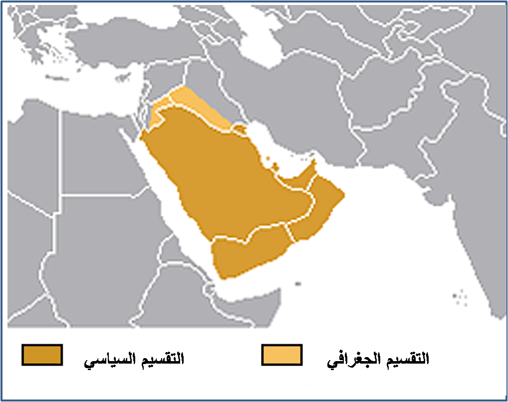
English: Translated as "the Arabian Peninsula Map" from arabic, where the map shows portions of Iraq and Syria that are colorized to inscribed within. (see note below.) This appears to be consistent with the tranlated title and this excerpt from Arabian pennisula:
"Its northern limit is defined by the w:Iranian and w:Iraqi mountain range of w:Zagros collision zone, a mountainous uplift where a w:continental collision between the w:Arabian Plate and Asia is occurring. It merges with the w:Syrian Desert with no clear line of demarcation. |
| التاريخ | 21 November |
| المصدر | عمل شخصي |
| المؤلف | إبن البيطار |
| الترخيص (إعادة استخدام هذا الملف) |
Look Bellow |
- note
English:
Previously erroneously categorized as "GCC countries" which has the meaning:
"Politically, the Arabian Peninsula consists of Saudi Arabia, Kuwait, Bahrain, Qatar, the United Arab Emirates, the Sultanate of Oman, and the Republic of Yemen. Together, these countries (excluding the Republic of Yemen located in the south-western corner of the pennisula) constitute the Gulf Cooperation Council (GCC), the subject of this map. Founded on 26 May 1981, the aim of this collective is to promote coordination between member states in all fields in order to achieve unity.— quote with minor annotation/links from GCC website.
- 2008-07-17 ... removed from that category as clearly off target. Yemen is same coloring, and portions of other geopolitical entities are indicated by other countries.
ترخيص
| أنا، مالِك حقوق تأليف ونشر هذا العمل، أجعله في النِّطاق العامِّ، يسري هذا في أرجاء العالم كلِّه. في بعض البلدان، قد يكون هذا التَّرخيص غيرَ مُمكنٍ قانونيَّاً، في هذه الحالة: أمنح الجميع حق استخدام هذا العمل لأي غرض دون أي شرط ما لم يفرض القانون شروطًا إضافية. |
تاريخ الملف
اضغط على زمن/تاريخ لرؤية الملف كما بدا في هذا الزمن.
| زمن/تاريخ | صورة مصغرة | الأبعاد | مستخدم | تعليق | |
|---|---|---|---|---|---|
| حالي | 09:19، 21 نوفمبر 2007 | | 1٬018 × 806 (394 كيلوبايت) | Producer | {{Information |Description=Translated the Arabian Peninsula Map in arabic |Source=self-made |Date=21 November |Author= إبن البيطار |Permission=Look Bellow |other_versions= }} |
استخدام الملف
لا توجد صفحات تستخدم هذا الملف.