ملف:Ankara districts.png
لا توجد دقة أعلى متوفرة.
Ankara_districts.png (733 × 600 بكسل حجم الملف: 166 كيلوبايت، نوع MIME: image/png)
| هذا ملف من ويكيميديا كومنز. معلومات من صفحة وصفه مبينة في الأسفل. كومنز مستودع ملفات ميديا ذو رخصة حرة. |
ملخص
| الوصف |
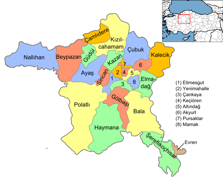
English: Map of the districts of Ankara province of Turkey. Created by Rarelibra 16:37, 1 December 2006 (UTC) for public domain use, using MapInfo Professional v8.5 and various mapping resources. Edited by One Homo Sapiens Corrected text where İ,Ş,ı,ğ,or ş occurs in name. Source: [statoids-com]. Increased font size and enhanced color differences among adjacent districts. |
| التاريخ | ١ ديسمبر ٢٠٠٦ (تاريخ الرفع الأصيل) |
| المصدر | لم يتم توفير مصدر قابل للقراءة، العمل الشخصي مفترض (بناء على مطالبات حقوق الطبع والنشر). |
| المؤلف | لم يتم توفير مؤلف قابل للقراءة; يُفترَض Rarelibra (استنادا إلى مطالبات حقوق الطبع والنشر). |
ترخيص
| أنا، مالِك حقوق تأليف ونشر هذا العمل، أجعله في النِّطاق العامِّ، يسري هذا في أرجاء العالم كلِّه. في بعض البلدان، قد يكون هذا التَّرخيص غيرَ مُمكنٍ قانونيَّاً، في هذه الحالة: أمنح الجميع حق استخدام هذا العمل لأي غرض دون أي شرط ما لم يفرض القانون شروطًا إضافية. |
تاريخ الملف
اضغط على زمن/تاريخ لرؤية الملف كما بدا في هذا الزمن.
| زمن/تاريخ | صورة مصغرة | الأبعاد | مستخدم | تعليق | |
|---|---|---|---|---|---|
| حالي | 15:08، 15 سبتمبر 2015 | | 733 × 600 (166 كيلوبايت) | AylakBiri | Yeni sınırlar. |
| 18:59، 1 يونيو 2014 |  | 1٬056 × 864 (198 كيلوبايت) | Joseph48 | - "Pursaklar" added. - Borders changed using File:Ankara location Pursaklar.svg | |
| 18:00، 22 أكتوبر 2011 |  | 1٬056 × 816 (48 كيلوبايت) | Karedefter | small things | |
| 19:40، 21 نوفمبر 2010 |  | 1٬056 × 816 (48 كيلوبايت) | Joseph48 | Şultan Koçhisar > Şerefli Koçhisar | |
| 20:37، 28 ديسمبر 2008 |  | 1٬056 × 816 (41 كيلوبايت) | One Homo Sapiens | Corrected text where İ,Ş,ı,ğ,or ş occurs in name. Source: [statoids-com]. Increased font size and enhanced color differences among adjacent districts. | |
| 16:37، 1 ديسمبر 2006 |  | 1٬056 × 816 (40 كيلوبايت) | Rarelibra | Map of the districts of Ankara province of Turkey. Created by ~~~~ for public domain use, using MapInfo Professional v8.5 and various mapping resources. |
استخدام الملف
الصفحتان التاليتان تستخدمان هذا الملف:
الاستخدام العالمي للملف
الويكيات الأخرى التالية تستخدم هذا الملف:
- الاستخدام في azb.wikipedia.org
- الاستخدام في az.wikipedia.org
- الاستخدام في ba.wikipedia.org
- الاستخدام في be.wikipedia.org
- الاستخدام في br.wikipedia.org
- الاستخدام في ca.wikipedia.org
- الاستخدام في ceb.wikipedia.org
- الاستخدام في ckb.wikipedia.org
- الاستخدام في crh.wikipedia.org
- الاستخدام في cs.wikipedia.org
- الاستخدام في cy.wikipedia.org
- الاستخدام في de.wikipedia.org
- Şereflikoçhisar
- Ankara (Provinz)
- Kızılcahamam
- Etimesgut
- Gölbaşı (Ankara)
- Haymana
- Evren (Ankara)
- Polatlı
- Sincan (Ankara)
- Vorlage:Navigationsleiste Landkreise der Provinz Ankara
- Çankaya
- Keçiören
- Mamak
- Kalecik
- Beypazarı
- Ayaş (Ankara)
- Yenimahalle
- Altındağ
- Balâ
- Elmadağ (Ankara)
- Nallıhan
- Pursaklar
- Çamlıdere (Ankara)
- Çubuk (Ankara)
اعرض المزيد من الاستخدام العام لهذا الملف.