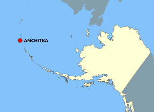
AmchitkaAlaskaLoc.png(300 × 219 بكسل حجم الملف: 14 كيلوبايت، نوع MIME: image/png)

ملخص

الوصف

This map is a derivative work of a map layer from nationalatlas.gov, which states: "We have begun by collaboratively building "frameworks," the essential map layers that provide a foundation for all other maps. These basic layers, including small-scale harmonized information on North American roads, water, boundaries and the like, are being offered here for the first time. Like all other raw data and documentation offered here on nationalatlas.gov, these frameworks can be downloaded at no cost and used freely without copyright concerns or license restrictions."[1]

I donate the modifications and the resulting work to the public domain.
المصدر see above
المؤلف National Atlas - DW: Jakew

ترخيص

Public domain
This map was obtained from an edition of the National Atlas of the United States. Like almost all works of the U.S. federal government, works from the National Atlas are in the public domain in the United States.
Online access: NationalAtlas.gov | 1970 print edition: Library of Congress, Perry-Castañeda Library

čeština | Deutsch | English | français | Bahasa Indonesia | italiano | македонски | മലയാളം | sicilianu | 中文 | 中文(简体)‎ | 中文(繁體)‎ | +/−

سجلُّ الرَّفع الأصيل

صفحة الوصف الأصلية كانت هنا، تشير جميع أسماء المستخدمين التالية إلى en.wikipedia.
  • 2006-10-08 16:15 Jakew 300×219×8 (14678 bytes) This map is a derivative work of a map layer from nationalatlas.gov, which states: "We have begun by collaboratively building "frameworks," the essential map layers that provide a foundation for all other maps. These basic layers, including small-scale ha

الشروحات

أضف شرحاً من سطر واحد لما يُمثِّله هذا الملف

العناصر المصورة في هذا الملف

يُصوِّر

29373e1014db60b020fe042aeb20de37cd506fdd

طريقة الاستدلال: SHA-1 الإنجليزية

١٤٬٦٧٨ بايت

٢١٩ بكسل

٣٠٠ بكسل

تاريخ الملف

اضغط على زمن/تاريخ لرؤية الملف كما بدا في هذا الزمن.

زمن/تاريخصورة مصغرةالأبعادمستخدمتعليق
حالي21:20، 2 أغسطس 2007تصغير للنسخة بتاريخ 21:20، 2 أغسطس 2007300 × 219 (14 كيلوبايت)Adam~commonswiki{{Information |Description=This map is a derivative work of a map layer from nationalatlas.gov, which states: "We have begun by collaboratively building "frameworks," the essential map layers that provide a foundation for all other maps. These basic layer

الصفحة التالية تستخدم هذا الملف:

الاستخدام العالمي للملف

الويكيات الأخرى التالية تستخدم هذا الملف: