ملف:AERONET Izana.2011288.aqua.250m.jpg

حجم هذه المعاينة: 800 × 600 بكسل. الأبعاد الأخرى: 320 × 240 بكسل | 640 × 480 بكسل | 1٬024 × 768 بكسل | 1٬280 × 960 بكسل | 2٬560 × 1٬920 بكسل | 3٬840 × 2٬880 بكسل.
الملف الأصلي (3٬840 × 2٬880 بكسل حجم الملف: 2٫47 ميجابايت، نوع MIME: image/jpeg)
| هذا ملف من ويكيميديا كومنز. معلومات من صفحة وصفه مبينة في الأسفل. كومنز مستودع ملفات ميديا ذو رخصة حرة. |
ملخص
| الوصف |
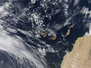
Español: Imagen de satélite de las Islas Canarias tomada por el MODIS de la NASA el 15 de octubre de 2011, donde se aprecia el tamaño de la mancha provocada por la erupción frente a las costas de El Hierro, España.
English: Satellite image of the Canary Islands taken by the MODIS of the NASA on October 15, 2011, where the size of the spot caused by the eruption off the coast of El Hierro, Spain is appreciated. |
| التاريخ |
|
| المصدر | |
| المؤلف |
Deutsch: Satellitenbild der Kanarischen Inseln, aufgenommen mit dem MODIS der NASA am 15. Oktober 2011, wo die Größe von wo die Größe des Flecks, der durch den Eruption vor der Küste von El Hierro, Spanien, verursacht wurde, gewürdigt wird.}}
English: Satellite image of the Canary Islands, Spain, taken by the MODIS of the NASA on October 15, 2011, |date=2011-10-15 |source=http://lance-modis.eosdis.nasa.gov/imagery/subsets/?subset=AERONET_Izana.2011288.aqua.250m |author=NASA |permission= |other_versions= |other_fields= }}
ترخيص
| يقع هذا العمل في النِّطاق العامّ في الولايات المُتحدة الأمريكيَّة لأَنَّه عملٌ خالِصٌ من إِنتاج وكالة الفضاء الأمريكيَّة. تنصُ حقوق التَّأليف والنَّشر الخاصَّة بوكالة الفضاء الأمريكيَّة على أنَّ "أعمال الوكالة غير مَحميَّة بحقوق التَّأليف والنَّشر ما لم يُذكر خلافُ ذلك". لمزيدٍ من المعلومات انظر القالِب {{PD-USGov}} وصفحة حقوق التَّأليف والنَّشر الخاصَّة بالوكالة وصفحة سياسة الصُّور الخاصَّة بمُختبر الدَّفع النَّفَّاث. | ||
 |
تنبيهات:
|
تاريخ الملف
اضغط على زمن/تاريخ لرؤية الملف كما بدا في هذا الزمن.
| زمن/تاريخ | صورة مصغرة | الأبعاد | مستخدم | تعليق | |
|---|---|---|---|---|---|
| حالي | 22:39، 15 أكتوبر 2011 | | 3٬840 × 2٬880 (2٫47 ميجابايت) | Gons |
استخدام الملف
الصفحتان التاليتان تستخدمان هذا الملف:
الاستخدام العالمي للملف
الويكيات الأخرى التالية تستخدم هذا الملف:
- الاستخدام في ca.wikipedia.org
- الاستخدام في es.wikipedia.org
- الاستخدام في es.wikivoyage.org