ملف:2010ElectoralCartogramGott.png
حجم هذه المعاينة: 800 × 516 بكسل. الأبعاد الأخرى: 320 × 206 بكسل | 640 × 412 بكسل | 900 × 580 بكسل.
الملف الأصلي (900 × 580 بكسل حجم الملف: 40 كيلوبايت، نوع MIME: image/png)
| هذا ملف من ويكيميديا كومنز. معلومات من صفحة وصفه مبينة في الأسفل. كومنز مستودع ملفات ميديا ذو رخصة حرة. |

|
هذه election map الصورة / الصورتان باستعمال رسومات متجهية ملفات رسوميات شعاعية.
It is recommended to name the SVG file "2010ElectoralCartogramGott.svg" - then the template Vector version available (or Vva) does not need the new image name parameter.
|
ملخص
| الوصف |
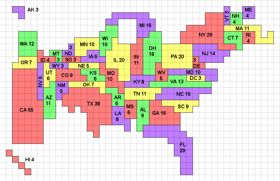
English: Gott and Colley's Electoral Cartogram showing the electoral votes apportioned to each state as a result of the 2010 Census. Note that the cartogram is topologically correct in that any state that borders another state in reality borders that state on the cartogram, and wherever multiple states meet at a point in reality, they also do so on the cartogram. The color map uses a 4-color system, which because of the topological correctness, could be applied to a standard geographic map as well. A previous version of this cartogram (reflecting the 2000 apportionment) was published in Mathematical and Computer Modeling. This image, and a monochrome version will be maintained at http://www.colleyrankings.com/cartogram2010, where one may also expect to find polling and election information in 2012. |
| التاريخ | |
| المصدر | عمل شخصي |
| المؤلف | Wes colley |
ترخيص
أنا، صاحب حقوق التأليف والنشر لهذا العمل، أنشر هذا العمل تحت الرخصة التالية:
هذا الملف مُرخص تحت رخصة المشاع المبدع نسبة المصنف إلى مؤلفه 3.0 العامة
- يحقُّ لك:
- مشاركة العمل – نسخ العمل وتوزيعه وبثُّه
- إعادة إنتاج العمل – تعديل العمل
- حسب الشروط التالية:
- نسب العمل إلى مُؤَلِّفه – يلزم نسب العمل إلى مُؤَلِّفه بشكل مناسب وتوفير رابط للرخصة وتحديد ما إذا أجريت تغييرات. بالإمكان القيام بذلك بأية طريقة معقولة، ولكن ليس بأية طريقة تشير إلى أن المرخِّص يوافقك على الاستعمال.
تاريخ الملف
اضغط على زمن/تاريخ لرؤية الملف كما بدا في هذا الزمن.
| زمن/تاريخ | صورة مصغرة | الأبعاد | مستخدم | تعليق | |
|---|---|---|---|---|---|
| حالي | 19:12، 5 يناير 2011 | | 900 × 580 (40 كيلوبايت) | Wes colley | Slight modification of annotations. |
| 16:59، 4 يناير 2011 |  | 900 × 580 (51 كيلوبايت) | Wes colley | {{Information |Description={{en|1=Gott's Electoral Cartogram showing the electoral votes apportioned to each state as a result of the 2010 Census. Note that the cartogram is topologically correct in that any state that borders another state in reality bor |
استخدام الملف
الصفحة التالية تستخدم هذا الملف:
الاستخدام العالمي للملف
الويكيات الأخرى التالية تستخدم هذا الملف:
- الاستخدام في en.wikipedia.org
- User:Straykat99
- User:Sf46
- User:Ano-User
- User:Lawrence142002
- User:BM6
- User:Mr. Magoo and McBarker
- User:Gdeblois19
- User:Steelers3814
- User:ChangeWithUs
- User:Twitbookspacetube
- Template:User electoral college
- Template:User electoral college support
- User:Bjohnston111
- User:Chad The Goatman
- User:Burrito74
- User:Madison-1996/My Political Views
- User:Nuew
- User:LydiaCHernandez
- User:Grey ghost
- User:Invinciblewalnut
- User:InspireWithUs
- الاستخدام في pt.wikipedia.org
- الاستخدام في th.wikipedia.org
- الاستخدام في uk.wikipedia.org