ملف:2008 09L 5-day track.gif
الملف الأصلي (895 × 716 بكسل حجم الملف: 37 كيلوبايت، نوع MIME: image/gif)
| هذا ملف من ويكيميديا كومنز. معلومات من صفحة وصفه مبينة في الأسفل. كومنز مستودع ملفات ميديا ذو رخصة حرة. |
ملخص
| الوصف |
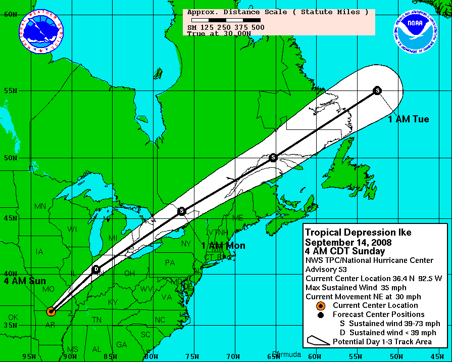
Hurricane Ike 5-day tracking map from NHC. The mileage ruler is in statute miles, where 5 degrees of latitude span 345.2 miles (555.8 km),[1][2] and 5 degrees of longitude at 30 degrees North latitude span 299.8 miles (482.7 km).[3] The scale and offset of the map can vary with each advisory (compare map boundaries of advisories 43 & 44), re-centered for the latest forecast path (white cone). |
| التاريخ | September 13, 2008 - 8AM CDT, Saturday |
| المصدر | http://www.nhc.noaa.gov/graphics_at4.shtml?5day#contents |
| المؤلف | NHC/NOAA |
ترخيص
تحتوي هذه الصُّورة مواداً أنتجت بواسطة الإدارة الوطنيَّة للمحيطات والغلاف الجوي في الولايات المتَّحدة الأمريكيَّة. أُنشئت هذه المواد مِن قبل مُوظَّفٍ خلال أدائه لواجباته الرَّسميَّة أي أنَّها عملٌ من أعمال الحكومة الاتحاديَّة للولايات المتَّحدة، ولذلك فهي في النِّطاق العامِّ.
|
Distances for latitude or longitude
Measured in statue miles, 5 degrees of latitude span 345.2 miles (555.8 km), based on 1 degree as 69.05 statute miles (111.2 km), or 60 nautical miles. [1][2]
Longitude varies in length according to degree of latitude.[2] The following are a sampling of longitude lengths for selected latitudes, starting in the southern US and moving north:
- at 30 degrees North (area of Houston, Texas), a degree of longitude is 59.96 statute miles;[2]
- at 35 degrees North (area of Albuquerque, NM), a degree of longitude is 56.73 statute miles;
- at 40 degrees North (Kansas/Nebraska border), a degree of longitude is 53.06 statute miles;
- at 45 degrees North (Montana/Wyoming border), a degree of longitude is 49.00 statute miles.[2]
At 30 degrees North (near Houston), 5 degrees of longitude span 299.8 miles (555.8 km),[3] and at 35 north (near Albuquerque), 5 degrees of longitude span 283.65 (~284 miles, 457 km).[3]
Notes
- ↑ a b "Weights and Measures" (conversion tables), Upper New England Coast (UNEC) Cyber Community, 1999, webpage: UNEC.
- ↑ a b c d e "Latitude-Longitude Conversion to Feet", The Sentinel, February 2001, webpage: HyperNews-SAR-291 نسخة مؤرشفة at the Wayback Machine.
- ↑ a b c For 30 degrees North, 5 degrees = 5 * 59.96 = 299.80 miles; for 35 degrees North, 5 degrees = 5 * 56.73 = 283.65 miles; based on the longitude conversion factors (see: References).
References
- "Latitude-Longitude Conversion to Feet", The Sentinel, February 2001, webpage: HyperNews-SAR-291 نسخة مؤرشفة at the Wayback Machine.
تاريخ الملف
اضغط على زمن/تاريخ لرؤية الملف كما بدا في هذا الزمن.
| زمن/تاريخ | صورة مصغرة | الأبعاد | مستخدم | تعليق | |
|---|---|---|---|---|---|
| حالي | 14:14، 14 سبتمبر 2008 | | 895 × 716 (37 كيلوبايت) | DOSGuy | Advisory 53 |
| 03:04، 14 سبتمبر 2008 |  | 895 × 716 (36 كيلوبايت) | DOSGuy | Advisory 52 | |
| 15:05، 13 سبتمبر 2008 |  | 895 × 716 (34 كيلوبايت) | DOSGuy | Advisory 50 | |
| 14:44، 13 سبتمبر 2008 |  | 895 × 716 (32 كيلوبايت) | Prosfilaes | Advisory 49B | |
| 09:11، 13 سبتمبر 2008 |  | 895 × 716 (33 كيلوبايت) | TheTallOne~commonswiki | == Summary == {{Information |Description=Hurricane Ike 5-day tracking map from NHC. The mileage ruler is in statute miles, where 5 degrees of latitude span 345.2 miles (555.8 km),<ref name=WMeas/><ref name=LLconv/> and 5 degree | |
| 01:42، 13 سبتمبر 2008 |  | 895 × 716 (28 كيلوبايت) | Smichae | Advisory 47B | |
| 23:57، 12 سبتمبر 2008 |  | 895 × 716 (28 كيلوبايت) | Prosfilaes | {{Information |Description= |Source= |Date= |Author= |Permission= |other_versions= }} | |
| 20:14، 12 سبتمبر 2008 |  | 895 × 716 (26 كيلوبايت) | Smichae | Advisory 46A | |
| 15:29، 12 سبتمبر 2008 |  | 895 × 716 (26 كيلوبايت) | MarsInSVG | {{Information |Description=Hurricane Ike 5-day tracking map from NHC. The mileage ruler is in statute miles, where 5 degrees of latitude span 345.2 miles (555.8 km),<ref name=WMeas/><ref name=LLconv/> and 5 degrees of longitude | |
| 09:04، 12 سبتمبر 2008 |  | 895 × 716 (34 كيلوبايت) | Keith Edkins | Advisory 45 |
استخدام الملف
الصفحة التالية تستخدم هذا الملف:
الاستخدام العالمي للملف
الويكيات الأخرى التالية تستخدم هذا الملف:
- الاستخدام في en.wikipedia.org
- الاستخدام في nl.wikipedia.org
- الاستخدام في pl.wikipedia.org
- الاستخدام في sv.wikipedia.org
- الاستخدام في ta.wikipedia.org