ملف:1945-02-15GerWW2BattlefrontAtlas.jpg
حجم هذه المعاينة: 616 × 600 بكسل. الأبعاد الأخرى: 247 × 240 بكسل | 493 × 480 بكسل | 789 × 768 بكسل | 1٬250 × 1٬217 بكسل.
الملف الأصلي (1٬250 × 1٬217 بكسل حجم الملف: 1٫26 ميجابايت، نوع MIME: image/jpeg)
| هذا ملف من ويكيميديا كومنز. معلومات من صفحة وصفه مبينة في الأسفل. كومنز مستودع ملفات ميديا ذو رخصة حرة. |

|
عُوِّض بهذا الملفُّ ملفٌ آخر هو File:1945-02-15GerWW2BattlefrontAtlas reworked.jpg، ويُنصح باستعمال هذا الملف. ملاحظة: لن يُحدف هذا الملف، إلا إذا قُدِّم طلب بالحذف في صفحة طلبات الحذف.
|

|
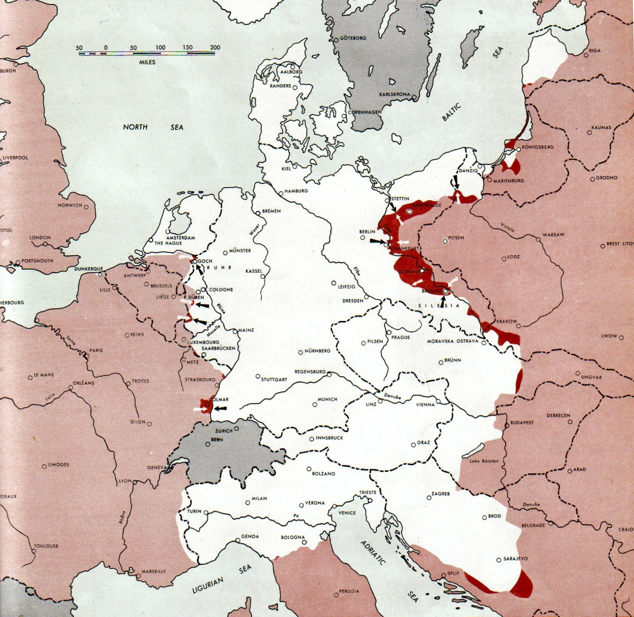
Atlas of the World Battle Fronts - War against Germany: 1945-02-15
← Previous map: 1945-02-01
→ Next map: 1945-03-01
ملخص
| الوصف |
Neutral nations (Sweden, Switzerland, Spain, Andorra)
Under Allied control
Allied forces
Axis forces or control
  July 1, 1943 to June 30 1945 To the Secretary of War". (See Cover, Forward and Map details)  |
| التاريخ | |
| المصدر | Document "Atlas of the World Battle Fronts in Semimonthly Phases to August 15th 1945: Supplement to The Biennial report of the Chief of Staff of the United States Army July 1, 1943 to June 30 1945 To the Secretary of War" |
| المؤلف | Army Map Service |
| الترخيص (إعادة استخدام هذا الملف) |
Public Domain: Work of US army |
ترخيص
هذه الصُّورة عمل لجنديٍّ أَو مُوظَّفٍ في جيش الولايات المُتحدة، التقطت أَو صُنعت بوصفها جزءاً مِن واجباته الرَّسميَّة. ولأنَّها عملٌ مِن أَعمال الحكومة الاتحاديَّة للولايات المتحدة فإنَّ هذه الصُّورة تقع في النِّطاق العامّ.
|
 |
تاريخ الملف
اضغط على زمن/تاريخ لرؤية الملف كما بدا في هذا الزمن.
| زمن/تاريخ | صورة مصغرة | الأبعاد | مستخدم | تعليق | |
|---|---|---|---|---|---|
| حالي | 09:15، 28 أغسطس 2011 | | 1٬250 × 1٬217 (1٫26 ميجابايت) | Finavon | 1 degree rotation; caption cropped |
| 19:16، 24 ديسمبر 2007 |  | 1٬274 × 1٬714 (1٫78 ميجابايت) | Mike Young | {{Information |Description= thumb|left|75pxthumb|right|75pxMap of the front against Germany: This map is taken from the source "Atlas of the World Battle Fronts in Semimonthly |
استخدام الملف
لا توجد صفحات تستخدم هذا الملف.
الاستخدام العالمي للملف
الويكيات الأخرى التالية تستخدم هذا الملف:
- الاستخدام في be-tarask.wikipedia.org
- الاستخدام في da.wikipedia.org
- الاستخدام في en.wikipedia.org
- الاستخدام في en.wikisource.org
- الاستخدام في es.wikipedia.org
- الاستخدام في hu.wikipedia.org
- الاستخدام في hy.wikipedia.org
- الاستخدام في id.wikipedia.org
- الاستخدام في ko.wikipedia.org
- الاستخدام في no.wikipedia.org
- الاستخدام في ro.wikipedia.org
- الاستخدام في vi.wikipedia.org
- الاستخدام في zh.wikipedia.org