ملف:1776 Rennell - Dury Wall Map of Bihar and Bengal, India - Geographicus - BaharBengal-dury-1776.jpg

الملف الأصلي (9٬106 × 6٬000 بكسل حجم الملف: 16٫86 ميجابايت، نوع MIME: image/jpeg)
| هذا ملف من ويكيميديا كومنز. معلومات من صفحة وصفه مبينة في الأسفل. كومنز مستودع ملفات ميديا ذو رخصة حرة. |
ملخص
| تنبيه | تحذير: يمكن لبعض مُتصفحي الإِنترنت أن يواجهوا صعوباتٍ لدى عرض هذه الصُّورة بدقَّتها الكامِلة: لدى هذه الصُّورة عدد ضخم غير اعتيادي مِن النِّقاط، ومِن المُحتمل عدم تحميلها بشكل صحيحٍ في المُتصفِّح الذي قد يتوقف عن العمل نتيجة لذلك. عوضاً عن ذلك، مِن المُستحسن أن تضغط بزرّ الفأرة اليمين على وصلة دقة كاملة وتحفظها على جهازك. عندها يمكن اسخدام برامج خارجية لعرض وتعديل الصورة.
|
|---|
| العنوان |
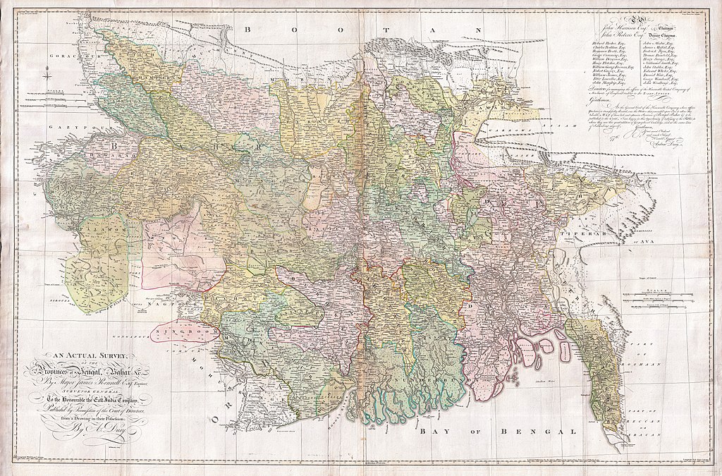
An Actual Survey, of the Provinces of Bengal, Bahar & c. by Major James Rennell Esq. Engineer to the Honorable the East India Company. Published by Permission of the Court of Directors from a Drawing in their Possession by A. Dury. |
|||||||||
| الوصف |
English: An altogether spectacular wall sized map of those parts of Bengal and Bihar, India. Follows the course of the Ganges River from Varanasi (Benares) eastward to the Ganges Delta and the Bay of Bengal. Includes Varanasi (Benares), Dacca (Dahka, Bengladesh), and Patna among many other important Indian cities. Bounded on the north by the Himalaya Mountains and the border with Bhutan. One of the first accurate maps of the interior of India. Laid out from primary surveys done by James Rennell, the first modern cartographer to map the interior of India. Notes cities, markets, battlefields, fortresses, roads, rivers, offers political commentary, and features some geographical references. Elaborate title in the lower left quadrant. Upper right quadrant features a dedication and letter of thanks written by Andrew Dury, the publisher, to the board of the East India Company. This is the first edition of this rare map – 1776 – as published by Dury. Later editions were published by Sayer and Bennet and by Laurie and Whittle.
Another high quality digitisation is available at the David Rumsey Historical Map Collection: [1] This map was published by Laurie and Whittle, as mentioned in the description by Geographicus for the 1776 map, in 1794. Regions are demarcated in coloured outlines instead of filled colours. A higher quality digitisation than that of Geographicus. Contains parts that are missing at the central vertical fold in the Geographicus digitisation of the 1776 map. Viewable in online Flash viewer and downloadable in MrSID format. |
|||||||||
| التاريخ | (dated) | |||||||||
| المصدر |
The Bengal Atlas ??, Rennell, James, (1779 first edition)
|
|||||||||
| الصانع | ||||||||||
| Geotemporal data | ||||||||||
| Bounding box |
|
|||||||||
| Georeferencing | ||||||||||
| Archival data | ||||||||||
| رقم التصنيف |
وصلة موقع جيوغرافيكوس: BaharBengal-dury-1776 |
|||||||||
| الأبعاد | ارتفاع: ٣٩٫٠ إنش (٩٩٫٠ سم)؛ عرض: ٥٩٫٠ إنش (١٤٩٫٨ سم) | |||||||||

|
قُيِّمت هذه الصورة وفقاً لمعايير تقييم الصُّور، ونتيجةً لذلك، فإنها تعدُّ صورةً ذات قيمةٍ عاليةٍ في كُومِنز في نطاق: Old maps of Bengal from 1776 by Major James Rennell. يُمكن أيضاً مُراجعة صفحة ترشيح الصُّورة للتقييم. |
ترخيص
|
هذا العمل يقع في النَّطاق العامّ في بلد المنشأ وفي البلدان الأخرى والمناطق التي تمتدُّ فيها مدة حقوق التَّأليف والنشر لتغطي زمن حياة المُؤلِّف و 100 سنةً بعد وفاته أو أقل من ذلك. يقع هذ العمل في النَّطاق العامِّ في الولايات المُتحدة الأمريكيَّة لأنَّه نُشِرَ (أو سُجِّل لدى مكتب الولايات المُتحدة لحقوق التَّأليف والنَّشر) قبل ١ يناير ١٩٢٩. | |
| هذا الملفُّ مَلحُوظُ بصفته غيرَ مُقيَّدٍ بحقوق التَّأليف والنشر، وهذا يشمل أيضاً الحقوق المُجاوِرة أَو ذات الصلة جميعُها. | |
تاريخ الملف
اضغط على زمن/تاريخ لرؤية الملف كما بدا في هذا الزمن.
| زمن/تاريخ | صورة مصغرة | الأبعاد | مستخدم | تعليق | |
|---|---|---|---|---|---|
| حالي | 08:39، 17 مارس 2011 | | 9٬106 × 6٬000 (16٫86 ميجابايت) | BotMultichill | {{subst:User:Multichill/Geographicus |link=http://www.geographicus.com/P/AntiqueMap/BaharBengal-dury-1776 |product_name=1776 Rennell - Dury Wall Map of Bihar and Bengal, India |map_title=An Actual Survey, of the Provinces of Bengal, Bahar & c. by Major Ja |
استخدام الملف
ال3 صفحات التالية تستخدم هذا الملف:
الاستخدام العالمي للملف
الويكيات الأخرى التالية تستخدم هذا الملف:
- الاستخدام في as.wikipedia.org
- الاستخدام في azb.wikipedia.org
- الاستخدام في bn.wikipedia.org
- الاستخدام في bn.wikisource.org
- الاستخدام في cs.wikipedia.org
- الاستخدام في el.wikipedia.org
- الاستخدام في en.wikipedia.org
- الاستخدام في es.wikipedia.org
- الاستخدام في fa.wikipedia.org
- الاستخدام في fr.wikipedia.org
- الاستخدام في hi.wikipedia.org
- الاستخدام في ja.wikipedia.org
- الاستخدام في ko.wikipedia.org
- الاستخدام في ml.wikipedia.org
- الاستخدام في mt.wikipedia.org
- الاستخدام في ne.wikipedia.org
- الاستخدام في nl.wikipedia.org
- الاستخدام في pnb.wikipedia.org
- الاستخدام في sa.wikipedia.org
اعرض المزيد من الاستخدام العام لهذا الملف.