قائمة أطول الجبال في المجموعة الشمسية
هذه قائمة بأطول الجبال في المجموعة الشمسية، أي أعلى قمة على كواكب المجموعة الشمسية، حيث تم قياس الجبال المهمة؛ في بعض الحالات يتم أيضًا سرد أعلى قمم لفئات مختلفة في ذلك العالم. يعتبر بركان الدرع الضخم أوليمبوس على المريخ أطول جبل على أي كوكب في المجموعة الشمسية بارتفاع قدره في 21.9 كم. بعد اكتشافه في عام 1971، كان أطول جبل معروف في المجموعة الشمسية، وظل كذلك لمدة 40 عامًا، لكن في عام 2011 تم العثور على الذروة المركزية للحفرة Rheasilvia على الكويكب وprotoplanet Vesta التي لها ارتفاع مماثل. بسبب القيود المفروضة على دقة القياسات وعدم وجود تعريف دقيق لـ «الأساس» الذي يتم القياس نسبة إليه، من الصعب تحديد أي منها أطول.[n 1]

القائمة عدل
مذكور المرتفعات من «القاعدة إلى الذروة»، لأنه لا يوجد مكافئ للارتفاع فوق مستوى سطح البحر في عوالم أخرى.
| العالم | أعلى قمة (قمم) | ارتفاع "القاعدة إلى الذروة" | % نسبة الارتفاع إلى نصف القطر[n 2] | سبب تكونه | ملاحظات |
|---|---|---|---|---|---|
| عطارد | Caloris Montes | ≤ 3 كـم (1.9 ميل)[1][2] | 0.12 | impact[3] | Formed by the Caloris impact |
| الزهرة | Skadi Mons (Maxwell Montes massif) | 6.4 كـم (4.0 ميل)[4] (11 km above mean) | 0.11 | tectonic[5] | Has radar-bright slopes due to metallic Venus snow, possibly lead sulfide[6] |
| Maat Mons | 4.9 كـم (3.0 ميل) (approx.)[7] | 0.081 | volcanic[8] | Highest volcano on Venus | |
| الأرض[n 3] | Mauna Kea and Mauna Loa | 10.2 كـم (6.3 ميل)[10] | 0.16 | volcanic | Just 4.2 كيلومتر (2.6 ميل) of this is above sea level |
| Haleakala | 9.1 كـم (5.7 ميل)[11] | 0.14 | volcanic | Rises 3.1 km above sea level | |
| Pico del Teide | 7.5 كـم (4.7 ميل)[12] | 0.12 | volcanic | Rises 3.7 km above sea level | |
| Denali | 5.3 إلى 5.9 كـم (3.3 إلى 3.7 ميل)[13] | 0.093 | tectonic | Tallest mountain base-to-peak on land[14][n 4] | |
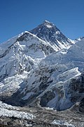
| Mount Everest | 3.6 إلى 4.6 كـم (2.2 إلى 2.9 ميل)[15] | 0.072 | tectonic | 4.6 km on north face, 3.6 km on south face;[n 5] highest elevation (8.8 km) above sea level (but not among the tallest from base to peak) | |
| Moon | Mons Huygens | 5.5 كـم (3.4 ميل)[16][17] | 0.32 | impact | Formed by the Imbrium impact |
| Mons Hadley | 4.5 كـم (2.8 ميل)[16][17] | 0.26 | impact | Formed by the Imbrium impact | |
| Mons Rümker | 1.1 كـم (0.68 ميل)[18] | 0.063 | volcanic | Largest volcanic construct on the Moon | |
| Mars | Olympus Mons | 21.9 كـم (14 ميل)[n 6][19][20] | 0.65 | volcanic | Rises 26 km above northern plains,[21] 1000 km away. Summit calderas are 60 x 80 km wide, up to 3.2 km deep;[20] scarp around margin is up to 8 km high.[22] |
| Ascraeus Mons | 14.9 كـم (9.3 ميل)[19] | 0.44 | volcanic | Tallest of the three Tharsis Montes | |
| Elysium Mons | 12.6 كـم (7.8 ميل)[19] | 0.37 | volcanic | Highest volcano in Elysium | |
| Arsia Mons | 11.7 كـم (7.3 ميل)[19] | 0.35 | volcanic | Summit caldera is 108 إلى 138 كيلومتر (67 إلى 86 ميل) across | |
| Pavonis Mons | 8.4 كـم (5.2 ميل)[19] | 0.25 | volcanic | Summit caldera is 4.8 كيلومتر (3.0 ميل) deep | |
| Anseris Mons | 6.2 كـم (3.9 ميل)[23] | 0.18 | impact | Among the highest nonvolcanic peaks on Mars, formed by the Hellas impact | |
| Aeolis Mons ("Mount Sharp") | 4.5 إلى 5.5 كـم (2.8 إلى 3.4 ميل)[24][n 7] | 0.16 | deposition and erosion[n 8] | Formed from deposits in Gale crater;[29] the MSL rover has been ascending it since November 2014.[30] | |
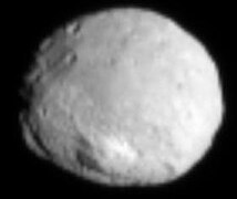
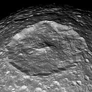
| 4 فيستا | Rheasilvia central peak | 22 كـم (14 ميل)[n 9][31][32] | 8.4 | impact | Almost 200 كيلومتر (120 ميل) wide. See also: List of largest craters in the Solar System |
| سيريس | Ahuna Mons | 4 كـم (2.5 ميل)[33] | 0.85 | cryovolcanic[34] | Isolated steep-sided dome in relatively smooth area; max. height of ~ 5 km on steepest side; roughly antipodal to largest impact basin on Ceres |
| Io | Boösaule Montes "South"[35] | 17.5 إلى 18.2 كـم (10.9 إلى 11.3 ميل)[36] | 1.0 | tectonic | Has a 15 كيلومتر (9 ميل) high scarp on its SE margin[37] |
| Ionian Mons east ridge | 12.7 كـم (7.9 ميل) (approx.)[37][38] | 0.70 | tectonic | Has the form of a curved double ridge | |
| Euboea Montes | 10.3 إلى 13.4 كـم (6.4 إلى 8.3 ميل)[39] | 0.74 | tectonic | A NW flank landslide left a 25,000 km3 debris apron[40][n 10] | |
| unnamed (245° W, 30° S) | 2.5 كـم (1.6 ميل) (approx.)[41][42] | 0.14 | volcanic | One of the tallest of Io's many volcanoes, with an atypical conical form[n 11] | |
| ميماس | Herschel central peak | 7 كـم (4 ميل) (approx.)[44] | 3.5 | impact | See also: List of largest craters in the Solar System |
| ديون | Janiculum Dorsa | 1.5 كـم (0.9 ميل)[45] | 0.27 | tectonic[n 12] | Surrounding crust depressed ca. 0.3 km. |
| تيتان | Mithrim Montes | ≤ 3.3 كـم (2.1 ميل)[48] | 0.13 | tectonic | May have formed due to global contraction[49] |
| Doom Mons | 1.45 كـم (0.90 ميل)[50] | 0.056 | cryovolcanic | Adjacent to Sotra Patera, a 1.7 كيلومتر (1.1 ميل) deep collapse feature | |
| إيابيتوس | equatorial ridge | 20 كـم (12 ميل) (approx.)[51] | 2.7 | uncertain[n 13] | Individual peaks have not been measured |
| أوبيرون | unnamed ("limb mountain") | 11 كـم (7 ميل) (approx.)[44] | 1.4 | impact (?) | A value of 6 km was given shortly after the Voyager 2 encounter[55] |
| بلوتو | Tenzing Montes, peak "T2" | ~6.2 كـم (3.9 ميل)[56] | 0.52 | tectonic (?) | Composed of water ice;[57] named after Tenzing Norgay[58] |
Piccard Monsاكتب عنوان المرجع بين علامتي الفتح <ref> والإغلاق </ref>[59][60]
|
~5.5 كـم (3.4 ميل)[56] | 0.46 | cryovolcanic (?) | ~220 km across;[61] central depression is 11 km deep | |
| Wright Mons[n 14] | ~4.7 كـم (2.9 ميل)[56] | 0.40 | cryovolcanic (?) | ~160 km across; summit depression ~56 km across[62] and 4.5 km deep | |
| شارون | Butler Mons[63] | ≥ 4.5 كـم (2.8 ميل)[63] | 0.74 | tectonic (?) | Vulcan Planitia, the southern plains, has several isolated peaks, possibly tilted crustal blocks |
| Dorothy central peak | ~4.0 كـم (2.5 ميل)[63] | 0.66 | impact | North polar impact basin Dorothy, Charon's largest, is ∼240 km across and 6 km deep |
معرض الصور عدل
يتم عرض الصور التالية بترتيب تنازلي وفق ارتفاع «القاعدة إلى الذروة».
-
-
 أوليمبوس مونس على سطح المريخ كما شوهد من فايكنغ 1 في عام 1978
 -
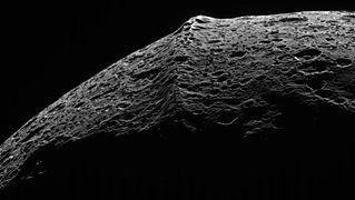 صورة كاسيني للتلال الاستوائية Iapetus
 -
 فوياجر 1 صورة لأعلى قمة لـ Io ، Boösaule Montes "South"
 -

-
 إيو يونتيس مونتيس (أسفل أعلى اليسار) وهايموس مونتيس (أسفل اليمين) ؛ شمال اليسار
 -

-
-
 صورة كاسيني لحفرة هيرشيل على ميماس وذروتها المركزية
 -

-

-
![أيوليس مونس ("جبل شارب") ، المريخ (كما يراها الفضول روفر في 6 أغسطس 2012). [n 15]](//upload.wikimedia.org/wikipedia/commons/thumb/6/65/673885main_PIA15986-full_full.jpg/180px-673885main_PIA15986-full_full.jpg)
-
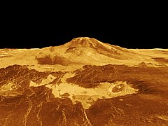 ماعت مونس ، فينوس (تصوير الرادار بالإضافة إلى قياس الارتفاع ، مبالغة رأسية 10x)
 -
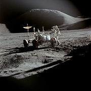 The Moon's Mons Hadley ، بالقرب من موقع هبوط أبولو 15 (1971)
 -
-
-

-
 آفاق جديدة لصورة تنزينز مونتيس بلوتو (أيضا في الصورة السابقة)
 -

-


![أيوليس مونس ("جبل شارب") ، المريخ (كما يراها الفضول روفر في 6 أغسطس 2012). [n 15]](/wiki/%D9%85%D9%84%D9%81:673885main_PIA15986-full_full.jpg)


انظر أيضا عدل
- قائمة البراكين خارج كوكب الأرض
- قائمة أكبر الحفر في النظام الشمسي
- قائمة أكبر الخلافات والوديان في النظام الشمسي
- قائمة أكبر البحيرات والبحار في النظام الشمسي
- مونس (علم الفلك)
- البروغرافيا الطبوغرافية
- قائمة أعلى الجبال على الأرض
- قائمة الجبال على سطح المريخ حسب الارتفاع
روابط خارجية عدل
- 3-D anaglyphs ذروة المركزية Rheasilvia لفي photojournal.jpl.nasa.gov: عرض رأس و عرض الجانب
- مناظر ملونة لذروة Rheasilvia المركزية في Planetary.org: منظر جانبي (ذروة في أعلى اليمين) وفسيفساء لنصف الكرة الجنوبي لفيستا
- بانوراما ملونة من Aeolis Mons من 21 سبتمبر 2012 (عرض أصغر متوازن الألوان هنا )
- عرض لون Aeolis Mons بواسطة سين دوران
- فيديو عالي الدقة من التحليق فوق سفوح أيوليس مونس بواسطة سين دوران
- بانوراما Gigapixel من Mt. ايفرست المنطقة التي كتبها ديفيد Breashears
ملاحظات عدل
- ^ جبل أوليمبس له قمة عريضة يصل قطرها إلى قطر فيستا.
- ^ نسبة ارتفاع الجبل إلى نصف قطر الكوكب الذي عليه
- ^ On Earth, mountain heights are constrained by جليدة ثلجية; peaks are usually limited to elevations not more than 1500 m above the خط الثلج الدائم (which varies with عرض جغرافي). Exceptions to this trend tend to be rapidly forming volcanoes.[9]
- ^ On p. 20 of Helman (2005): "the base to peak rise of Mount McKinley is the largest of any mountain that lies entirely above sea level, some 18,000 ft (5,500 m)"
- ^ Peak is 8.8 كـم (5.5 ميل) above sea level, and over 13 كـم (8.1 ميل) above the oceanic سهل سحيق.
- ^ Due to limitations in the accuracy of the measurements and the lack of a precise definition of "base", it is difficult to say whether this peak or the central peak of Vesta's crater Rheasilvia is the tallest mountain in the Solar System.
- ^ About 5.25 كـم (3.26 ميل) high from the perspective of the landing site of Curiosity.[25]
- ^ A crater central peak may sit below the mound of sediment. If that sediment was deposited while the crater was flooded, the crater may have once been entirely filled before تعريةal processes gained the upper hand.[24] However, if the deposition was due to رياح سفحية هابطةs that descend the crater walls, as suggested by reported 3 degree radial slopes of the mound's layers, the role of erosion would have been to place an upper limit on the mound's growth.[26][27] Gravity measurements by Curiosity suggest the crater was never buried by sediment, consistent with the latter scenario.[28]
- ^ Due to limitations in the accuracy of the measurements and the lack of a precise definition of "base", it is difficult to say whether this peak or the volcano Olympus Mons on Mars is the tallest mountain in the Solar System.
- ^ Among the Solar System's largest[40]
- ^ Some of Io's paterae are surrounded by radial patterns of lava flows, indicating they are on a topographic high point, making them shield volcanoes. Most of these volcanoes exhibit relief of less than 1 km. A few have more relief; Ruwa Patera rises 2.5 to 3 km over its 300 km width. However, its slopes are only on the order of a degree.[43] A handful of Io's smaller shield volcanoes have steeper, conical profiles; the example listed is 60 km across and has slopes averaging 4° and reaching 6-7° approaching the small summit depression.[43]
- ^ Was apparently formed via contraction.[46][47]
- ^ Hypotheses of origin include crustal readjustment associated with a decrease in سطح كروي due to تقييد مدي,[52][53] and deposition of deorbiting material from a former ring around the moon.[54]
- ^ Name not yet approved by the الاتحاد الفلكي الدولي
- ^ A linearized wide-angle كيوريوسيتي روفر image that makes the mountain look steeper than it actually is. The highest peak is not visible in this view.
المراجع عدل
- ^ "Surface". MESSENGER web site. جامعة جونز هوبكينز/مختبر الفيزياء التطبيقية. مؤرشف من الأصل في 2016-11-02. اطلع عليه بتاريخ 2012-04-04.
- ^ Oberst، J.؛ Preusker، F.؛ Phillips، R. J.؛ Watters، T. R.؛ Head، J. W.؛ Zuber، M. T.؛ Solomon، S. C. (2010). "The morphology of Mercury's Caloris basin as seen in MESSENGER stereo topographic models". Icarus. ج. 209 ع. 1: 230–238. Bibcode:2010Icar..209..230O. DOI:10.1016/j.icarus.2010.03.009. ISSN:0019-1035.
- ^ Fassett، C. I.؛ Head، J. W.؛ Blewett، D. T.؛ Chapman، C. R.؛ Dickson، J. L.؛ Murchie، S. L.؛ Solomon، S. C.؛ Watters، T. R. (2009). "Caloris impact basin: Exterior geomorphology, stratigraphy, morphometry, radial sculpture, and smooth plains deposits". Earth and Planetary Science Letters. ج. 285 ع. 3–4: 297–308. Bibcode:2009E&PSL.285..297F. DOI:10.1016/j.epsl.2009.05.022. ISSN:0012-821X.
- ^ Jones, Tom؛ Stofan, Ellen (2008). Planetology : Unlocking the secrets of the solar system. Washington, D.C.: National Geographic Society. ص. 74. ISBN:978-1-4262-0121-9. مؤرشف من الأصل في 2017-07-16.
- ^ Keep، M.؛ Hansen، V. L. (1994). "Structural history of Maxwell Montes, Venus: Implications for Venusian mountain belt formation". Journal of Geophysical Research. ج. 99 ع. E12: 26015. Bibcode:1994JGR....9926015K. DOI:10.1029/94JE02636. ISSN:0148-0227.
- ^ Otten، Carolyn Jones (10 فبراير 2004). "'Heavy metal' snow on Venus is lead sulfide". Newsroom. جامعة واشنطن في سانت لويس. مؤرشف من الأصل في 2016-01-29. اطلع عليه بتاريخ 2012-12-10.
- ^ "PIA00106: Venus - 3D Perspective View of Maat Mons". Planetary Photojournal. مختبر الدفع النفاث. 1 أغسطس 1996. مؤرشف من الأصل في 2019-08-10. اطلع عليه بتاريخ 2012-06-30.
- ^ Robinson، C. A.؛ Thornhill, G. D.؛ Parfitt, E. A. (يناير 1995). "Large-scale volcanic activity at Maat Mons: Can this explain fluctuations in atmospheric chemistry observed by Pioneer Venus?". Journal of Geophysical Research. ج. 100 ع. E6: 11755–11764. Bibcode:1995JGR...10011755R. DOI:10.1029/95JE00147. مؤرشف من الأصل في 2012-11-09. اطلع عليه بتاريخ 2013-02-11.
- ^ Egholm، D. L.؛ Nielsen، S. B.؛ Pedersen، V. K.؛ Lesemann، J.-E. (2009). "Glacial effects limiting mountain height". Nature. ج. 460 ع. 7257: 884–887. DOI:10.1038/nature08263.
- ^ "Mountains: Highest Points on Earth". National Geographic Society. مؤرشف من الأصل في 2017-02-06. اطلع عليه بتاريخ 2010-09-19.
- ^ "Haleakala National Park Geology Fieldnotes". U.S. National Park Service. مؤرشف من الأصل في 2017-02-02. اطلع عليه بتاريخ 2017-01-31.
- ^ "Teide National Park". UNESCO World Heritage Site list. يونسكو. مؤرشف من الأصل في 2019-09-03. اطلع عليه بتاريخ 2013-06-02.
- ^ "NOVA Online: Surviving Denali, The Mission". NOVA web site. Public Broadcasting Corporation. 2000. مؤرشف من الأصل في 2018-10-25. اطلع عليه بتاريخ 2007-06-07.
- ^ Adam Helman (2005). The Finest Peaks: Prominence and Other Mountain Measures. Trafford Publishing. ISBN:978-1-4120-5995-4. مؤرشف من الأصل في 2014-06-27. اطلع عليه بتاريخ 2012-12-09.
- ^ Mount Everest (1:50,000 scale map), prepared under the direction of برادفورد واشبورن for the Boston Museum of Science, the Swiss Foundation for Alpine Research, and the منظمة ناشيونال جيوغرافيك, 1991, (ردمك 3-85515-105-9)
- ^ أ ب Fred W. Price (1988). The Moon observer's handbook. London: Cambridge University Press. ISBN:978-0-521-33500-3.
- ^ أ ب Moore، Patrick (2001). On the Moon. London: Cassell & Co.
{{استشهاد بكتاب}}: صيانة الاستشهاد: التاريخ والسنة (link) - ^ Wöhler, C.؛ Lena, R.؛ Pau, K. C. (16 مارس 2007)، "The Lunar Dome Complex Mons Rümker: Morphometry, Rheology, and Mode of Emplacement"، Lunar and Planetary Science Conference، ص. 1091، Bibcode:2007LPI....38.1091W
{{استشهاد}}: الوسيط غير المعروف|عنوان الكتاب=تم تجاهله (مساعدة) - ^ أ ب ت ث ج Plescia، J. B. (2004). "Morphometric properties of Martian volcanoes". Journal of Geophysical Research. ج. 109 ع. E3: E03003. Bibcode:2004JGRE..109.3003P. DOI:10.1029/2002JE002031. ISSN:0148-0227.
- ^ أ ب Carr, Michael H. (11 يناير 2007). The Surface of Mars. Cambridge University Press. ص. 51. ISBN:978-1-139-46124-5. مؤرشف من الأصل في 2017-02-15.
- ^ Comins، Neil F. (4 يناير 2012). Discovering the Essential Universe. Macmillan. ISBN:978-1-4292-5519-6. مؤرشف من الأصل في 2020-01-26. اطلع عليه بتاريخ 2012-12-23.
- ^ Lopes، R.؛ Guest، J. E.؛ Hiller، K.؛ Neukum، G. (يناير 1982). "Further evidence for a mass movement origin of the Olympus Mons aureole". Journal of Geophysical Research. ج. 87 ع. B12: 9917–9928. Bibcode:1982JGR....87.9917L. DOI:10.1029/JB087iB12p09917.
- ^ JMARS MOLA elevation dataset. Christensen, P.; Gorelick, N.; Anwar, S.; Dickenshied, S.; Edwards, C.; Engle, E. (2007) "New Insights About Mars From the Creation and Analysis of Mars Global Datasets;" American Geophysical Union, Fall Meeting, abstract #P11E-01. نسخة محفوظة 5 أكتوبر 2018 على موقع واي باك مشين.
- ^ أ ب "Gale Crater's History Book". Mars Odyssey THEMIS web site. جامعة ولاية أريزونا. مؤرشف من الأصل في 2008-11-04. اطلع عليه بتاريخ 2012-12-07.
- ^ Anderson، R. B.؛ Bell III، J. F. (2010). "Geologic mapping and characterization of Gale Crater and implications for its potential as a Mars Science Laboratory landing site". International Journal of Mars Science and Exploration. ج. 5: 76–128. Bibcode:2010IJMSE...5...76A. DOI:10.1555/mars.2010.0004. مؤرشف من الأصل في 2019-06-07.
- ^ Wall، M. (6 مايو 2013). "Bizarre Mars Mountain Possibly Built by Wind, Not Water". Space.com. مؤرشف من الأصل في 2019-04-28. اطلع عليه بتاريخ 2013-05-13.
- ^ Kite، E. S.؛ Lewis، K. W.؛ Lamb، M. P.؛ Newman، C. E.؛ Richardson، M. I. (2013). "Growth and form of the mound in Gale Crater, Mars: Slope wind enhanced erosion and transport". Geology. ج. 41 ع. 5: 543–546. arXiv:1205.6840. Bibcode:2013Geo....41..543K. DOI:10.1130/G33909.1. ISSN:0091-7613.
- ^ Lewis، K. W.؛ Peters، S.؛ Gonter، K.؛ Morrison، S.؛ Schmerr، N.؛ Vasavada، A. R.؛ Gabriel، T. (2019). "A surface gravity traverse on Mars indicates low bedrock density at Gale crater". Science. ج. 363 ع. 6426: 535–537. DOI:10.1126/science.aat0738.
- ^ Agle، D. C. (28 مارس 2012). "'Mount Sharp' On Mars Links Geology's Past and Future". ناسا. مؤرشف من الأصل في 2019-06-04. اطلع عليه بتاريخ 2012-03-31.
- ^ Webster، Gay؛ Brown، Dwayne (9 نوفمبر 2014). "Curiosity Arrives at Mount Sharp". NASA Jet Propulsion Laboratory. مؤرشف من الأصل في 2016-12-12. اطلع عليه بتاريخ 2016-10-16.
- ^ Vega، P. (11 أكتوبر 2011). "New View of Vesta Mountain From NASA's Dawn Mission". Jet Propulsion Lab's Dawn mission web site. ناسا. مؤرشف من الأصل في 2011-10-22. اطلع عليه بتاريخ 2012-03-29.
- ^ Schenk، P.؛ Marchi، S.؛ O'Brien، D. P.؛ Buczkowski، D.؛ Jaumann، R.؛ Yingst، A.؛ McCord، T.؛ Gaskell، R.؛ Roatsch، T.؛ Keller، H. E.؛ Raymond، C.A.؛ Russell، C. T. (1 مارس 2012)، "Mega-Impacts into Planetary Bodies: Global Effects of the Giant Rheasilvia Impact Basin on Vesta"، Lunar and Planetary Science Conference، ص. 2757، Bibcode:2012LPI....43.2757S، contribution 1659, id.2757
{{استشهاد}}: الوسيط غير المعروف|عنوان الكتاب=تم تجاهله (مساعدة) - ^ "Dawn's First Year at Ceres: A Mountain Emerges". JPL Dawn website. مختبر الدفع النفاث. 7 مارس 2016. مؤرشف من الأصل في 2017-02-18. اطلع عليه بتاريخ 2016-03-08.
- ^ Ruesch، O.؛ Platz، T.؛ Schenk، P.؛ McFadden، L. A.؛ Castillo-Rogez، J. C.؛ Quick، L. C.؛ Byrne، S.؛ Preusker، F.؛ OBrien، D. P. (2 سبتمبر 2016). "Cryovolcanism on Ceres". Science. ج. 353 ع. 6303: aaf4286. Bibcode:2016Sci...353.4286R. DOI:10.1126/science.aaf4286. PMID:27701087.
- ^ Perry، Jason (27 يناير 2009). "Boösaule Montes". Gish Bar Times blog. مؤرشف من الأصل في 2019-07-30. اطلع عليه بتاريخ 2012-06-30.
- ^ Schenk، P.؛ Hargitai, H. "Boösaule Montes". Io Mountain Database. مؤرشف من الأصل في 2019-07-25. اطلع عليه بتاريخ 2012-06-30.
- ^ أ ب Schenk، P.؛ Hargitai، H.؛ Wilson، R.؛ McEwen، A.؛ Thomas، P. (2001). "The mountains of Io: Global and geological perspectives from Voyager and Galileo". Journal of Geophysical Research. ج. 106 ع. E12: 33201. Bibcode:2001JGR...10633201S. DOI:10.1029/2000JE001408. ISSN:0148-0227.
- ^ Schenk، P.؛ Hargitai, H. "Ionian Mons". Io Mountain Database. مؤرشف من الأصل في 2019-07-29. اطلع عليه بتاريخ 2012-06-30.
- ^ Schenk، P.؛ Hargitai, H. "Euboea Montes". Io Mountain Database. مؤرشف من الأصل في 2018-10-03. اطلع عليه بتاريخ 2012-06-30.
- ^ أ ب Martel، L. M. V. (16 فبراير 2011). "Big Mountain, Big Landslide on Jupiter's Moon, Io". NASA Solar System Exploration web site. مؤرشف من الأصل في 2015-06-26. اطلع عليه بتاريخ 2012-06-30.
- ^ Moore، J. M.؛ McEwen، A. S.؛ Albin، E. F.؛ Greeley، R. (1986). "Topographic evidence for shield volcanism on Io". Icarus. ج. 67 ع. 1: 181–183. Bibcode:1986Icar...67..181M. DOI:10.1016/0019-1035(86)90183-1. ISSN:0019-1035.
- ^ Schenk، P.؛ Hargitai, H. "Unnamed volcanic mountain". Io Mountain Database. مؤرشف من الأصل في 2019-07-31. اطلع عليه بتاريخ 2012-12-06.
- ^ أ ب Schenk، P. M.؛ Wilson, R. R.؛ Davies, R. G. (2004). "Shield volcano topography and the rheology of lava flows on Io". Icarus. ج. 169 ع. 1: 98–110. Bibcode:2004Icar..169...98S. DOI:10.1016/j.icarus.2004.01.015.
- ^ أ ب Moore، Jeffrey M.؛ Schenk، Paul M.؛ Bruesch، Lindsey S.؛ Asphaug، Erik؛ McKinnon، William B. (أكتوبر 2004). "Large impact features on middle-sized icy satellites" (PDF). Icarus. ج. 171 ع. 2: 421–443. Bibcode:2004Icar..171..421M. DOI:10.1016/j.icarus.2004.05.009. مؤرشف من الأصل (PDF) في 2018-10-02.
- ^ Hammond، N. P.؛ Phillips، C. B.؛ Nimmo، F.؛ Kattenhorn، S. A. (مارس 2013). "Flexure on Dione: Investigating subsurface structure and thermal history". Icarus. ج. 223 ع. 1: 418–422. Bibcode:2013Icar..223..418H. DOI:10.1016/j.icarus.2012.12.021.
- ^ Beddingfield، C. B.؛ Emery، J. P.؛ Burr، D. M. (مارس 2013)، "Testing for a Contractional Origin of Janiculum Dorsa on the Northern, Leading Hemisphere of Saturn's Moon Dione"، Lunar and Planetary Science Conference، ص. 1301، Bibcode:2013LPI....44.1301B
{{استشهاد}}: الوسيط غير المعروف|عنوان الكتاب=تم تجاهله (مساعدة) - ^ Overlooked Ocean Worlds Fill the Outer Solar System. John Wenz, Scientific American. 4 October 2017. نسخة محفوظة 26 ديسمبر 2018 على موقع واي باك مشين.
- ^ "PIA20023: Radar View of Titan's Tallest Mountains". Photojournal.jpl.nasa.gov. مختبر الدفع النفاث. 24 مارس 2016. مؤرشف من الأصل في 2017-08-25. اطلع عليه بتاريخ 2016-03-25.
- ^ Mitri، G.؛ Bland,M. T.؛ Showman, A. P.؛ Radebaugh, J.؛ Stiles, B.؛ Lopes, R. M. C.؛ Lunine, J. I.؛ Pappalardo, R. T. (2010). "Mountains on Titan: Modeling and observations". مجلة البحوث الجيوفيزيائية. ج. 115 ع. E10002: E10002. Bibcode:2010JGRE..11510002M. DOI:10.1029/2010JE003592. مؤرشف من الأصل في 2020-01-26. اطلع عليه بتاريخ 2012-07-05.
- ^ Lopes، R. M. C.؛ Kirk, R. L.؛ Mitchell, K. L.؛ LeGall, A.؛ Barnes, J. W.؛ Hayes, A.؛ Kargel, J.؛ Wye, L.؛ Radebaugh, J.؛ Stofan, E. R.؛ Janssen, M. A.؛ Neish, C. D.؛ Wall, S. D.؛ Wood, C. A.؛ Lunine, J. I.؛ Malaska, M. J. (19 مارس 2013). "Cryovolcanism on Titan: New results from Cassini RADAR and VIMS" (PDF). Journal of Geophysical Research: Planets. ج. 118 ع. 3: 416. Bibcode:2013JGRE..118..416L. DOI:10.1002/jgre.20062. مؤرشف من الأصل (PDF) في 2019-09-01.
- ^ Giese، B.؛ Denk, T.؛ Neukum, G.؛ Roatsch, T.؛ Helfenstein, P.؛ Thomas, P. C.؛ Turtle, E. P.؛ McEwen, A.؛ Porco, C. C. (2008). "The topography of Iapetus' leading side". Icarus. ج. 193 ع. 2: 359–371. Bibcode:2008Icar..193..359G. DOI:10.1016/j.icarus.2007.06.005. ISSN:0019-1035. مؤرشف من الأصل (PDF) في 2020-03-13.
- ^ Porco، C. C.؛ وآخرون (2005). "Cassini Imaging Science: Initial Results on Phoebe and Iapetus" (PDF). Science. ج. 307 ع. 5713: 1237–1242. Bibcode:2005Sci...307.1237P. DOI:10.1126/science.1107981. ISSN:0036-8075. PMID:15731440. 2005Sci...307.1237P. مؤرشف من الأصل (PDF) في 2018-07-19.
- ^ Kerr، Richard A. (6 يناير 2006). "How Saturn's Icy Moons Get a (Geologic) Life". Science. ج. 311 ع. 5757: 29. DOI:10.1126/science.311.5757.29. PMID:16400121. مؤرشف من الأصل في 2008-08-07.
- ^ Ip، W.-H. (2006). "On a ring origin of the equatorial ridge of Iapetus" (PDF). Geophysical Research Letters. ج. 33 ع. 16: L16203. Bibcode:2006GeoRL..3316203I. DOI:10.1029/2005GL025386. ISSN:0094-8276. مؤرشف من الأصل (PDF) في 2019-06-26.
- ^ Moore، P.؛ Henbest, N. (أبريل 1986). "Uranus - the View from Voyager". Journal of the British Astronomical Association. ج. 96 ع. 3: 131–137. Bibcode:1986JBAA...96..131M. مؤرشف من الأصل في 2018-10-05. اطلع عليه بتاريخ 2012-07-07.
- ^ أ ب ت Schenk، P. M.؛ Beyer، R. A.؛ McKinnon، W. B.؛ Moore، J. M.؛ Spencer، J. R.؛ White، O. L.؛ Singer، K.؛ Nimmo، F.؛ Thomason، C.؛ Lauer، T. R.؛ Robbins، S.؛ Umurhan، O. M.؛ Grundy، W. M.؛ Stern، S. A.؛ Weaver، H. A.؛ Young، L. A.؛ Smith، K. E.؛ Olkin، C. (2018). "Basins, fractures and volcanoes: Global cartography and topography of Pluto from New Horizons". Icarus. ج. 314: 400–433. DOI:10.1016/j.icarus.2018.06.008.
- ^ Hand، E.؛ Kerr، R. (15 يوليو 2015). "Pluto is alive—but where is the heat coming from?". Science. DOI:10.1126/science.aac8860.
- ^ Pokhrel، Rajan (19 يوليو 2015). "Nepal's mountaineering fraternity happy over Pluto mountains named after Tenzing Norgay Sherpa - Nepal's First Landmark In The Solar System". The Himalayan Times. مؤرشف من الأصل في 2015-08-13. اطلع عليه بتاريخ 2015-07-19.
- ^ "At Pluto, New Horizons Finds Geology of All Ages, Possible Ice Volcanoes, Insight into Planetary Origins". New Horizons News Center. The Johns Hopkins University Applied Physics Laboratory LLC. 9 نوفمبر 2015. مؤرشف من الأصل في 2019-09-03. اطلع عليه بتاريخ 2015-11-09.
- ^ Witze، A. (9 نوفمبر 2015). "Icy volcanoes may dot Pluto's surface". Nature. DOI:10.1038/nature.2015.18756. مؤرشف من الأصل في 2017-05-02. اطلع عليه بتاريخ 2015-11-09.
- ^ "Ice Volcanoes and Topography". New Horizons Multimedia. The Johns Hopkins University Applied Physics Laboratory LLC. 9 نوفمبر 2015. مؤرشف من الأصل في 2018-07-05. اطلع عليه بتاريخ 2015-11-09.
- ^ "Ice Volcanoes on Pluto?". New Horizons Multimedia. The Johns Hopkins University Applied Physics Laboratory LLC. 9 نوفمبر 2015. مؤرشف من الأصل في 2017-09-11. اطلع عليه بتاريخ 2015-11-09.
- ^ أ ب ت Schenk، P. M.؛ Beyer، R. A.؛ McKinnon، W. B.؛ Moore، J. M.؛ Spencer، J. R.؛ White، O. L.؛ Singer، K.؛ Umurhan، O. M.؛ Nimmo، F. (2018). "Breaking up is hard to do: Global cartography and topography of Pluto's mid-sized icy Moon Charon from New Horizons". Icarus. ج. 315: 124–145. DOI:10.1016/j.icarus.2018.06.010.