ملف:German and Japanese spheres of influence at greatest extent World War II 1942.jpg

حجم هذه المعاينة: 800 × 471 بكسل. الأبعاد الأخرى: 320 × 188 بكسل | 640 × 377 بكسل | 877 × 516 بكسل.
الملف الأصلي (877 × 516 بكسل حجم الملف: 172 كيلوبايت، نوع MIME: image/jpeg)
| هذا ملف من ويكيميديا كومنز. معلومات من صفحة وصفه مبينة في الأسفل. كومنز مستودع ملفات ميديا ذو رخصة حرة. |

|
هذه military map الصورة / الصورتان باستعمال رسومات متجهية ملفات رسوميات شعاعية.
It is recommended to name the SVG file "German and Japanese spheres of influence at greatest extent World War II 1942.svg" - then the template Vector version available (or Vva) does not need the new image name parameter.
|


| الوصف |
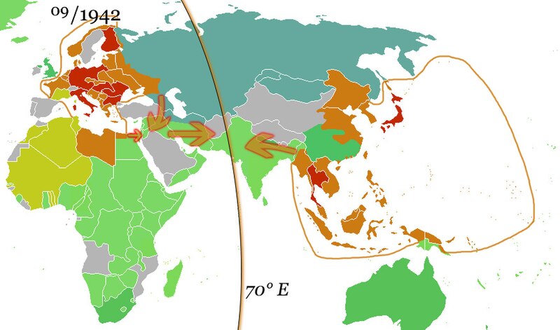
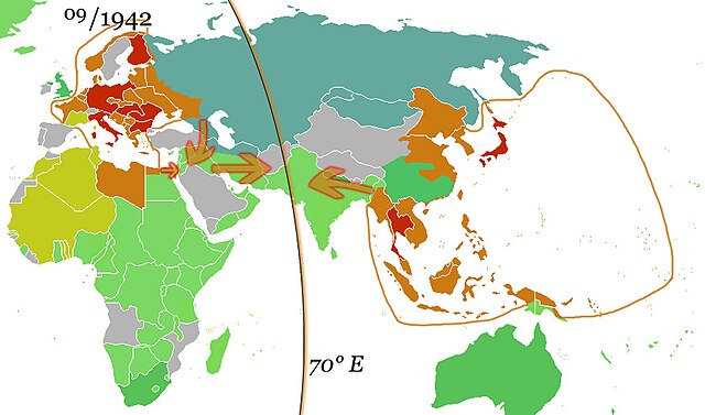
English: The German and the Japanese direct spheres of influence at their greatest extents during the Second World War in fall 1942. Arrows show planned movements to an agreed demarcation line at 70° E, which was, however, never even approximated.
The Allied countries.
Colonies, occupied territories and sphere of influence of the Allies.
The Axis countries.
Colonies, occupied territories and sphere of influence of the Axis
Vichy France and her remaining colonies.
The Soviet Union, its satellite states and sphere of influence.
Neutral countries. Deutsch: Die japanischen und deutschen direkten Einflusssphären während des zweiten Weltkrieges zum Zeitpunkt ihrer größten Ausdehnung im Herbst 1942. Pfeile zeigen geplante Bewegungen in Richtung einer vereinbarten Demarkationslinie entlang 70° östl. Länge, welche jedoch nie auch nur ansatzweise erreicht wurde.
Alliierte
Kolonien, besetzte Gebiete und Einflussbereiche der Alliierten
Achsenmächte
Kolonien, besetzte Gebiete und Einflussbereiche der Achse
Vichy-Frankreich und verbliebene Kolonien
Sowjetunion, ihre Satellitenstaaten und Einflussbereiche
Neutrale Staaten Русский: Немецкая и японская прямые сферы влияния достигли наибольшей степени во время Второй мировой войны осенью 1942 года. Стрелки показывают запланированные перемещения к согласованной демаркационной линии на 70° восточной долготы, которая, однако, никогда даже приблизительно не была определена.
Страны союзников.
Колонии, оккупированные территории и сферы влияния союзников.
Страны «Оси».
Колонии, оккупированные территории и сферы влияния стран Оси
Вишистская Франция и её оставшиеся колонии.
Советский Союз, его государства-сателлиты и сфера влияния.
Нейтральные страны. |
| التاريخ | (UTC) |
| المصدر | |
| المؤلف |
|
| هذا رسمٌ مُعَدَّلٌ رقميَّاً من النسخة الأصليَّة. التعديلات هي: Added spheres of influence and 70° E.. يُمكن الاطلاع على النسخة الأصليَّة هنا: Ww2 allied axis.gif: File:Ww2 allied axis.gif. المُستخدم الذي أجرى التعديلات هو: 36ophiuchi.
|
أنا، صاحب حقوق التأليف والنشر لهذا العمل، أنشر هذا العمل تحت الرخص التالية:
| هذا الملفُّ مُرخَّص بموجب رخصة المشاع الإبداعي نسبة المُصنَّف إِلى مُؤَلِّفه - المشاركة بالمثل 3.0 العامة | ||
| ||
| تمت إضافة علامة الترخيص لهذا الملف كجزء من رخصة جنو للوثائق الحرة تحديث الترخيص. |

|
يسمح نسخ وتوزيع و/أو تعديل هذه الوثيقة تحت شروط رخصة جنو للوثائق الحرة، الإصدار 1.2 أو أي إصدار لاحق تنشره مؤسسة البرمجيات الحرة؛ دون أقسام ثابتة ودون نصوص أغلفة أمامية ودون نصوص أغلفة خلفية. نسخة من الرخصة تم تضمينها في القسم المسمى GNU Free Documentation License. |
لك أن تختار الرخصة التي تناسبك.
سجلُّ الرَّفع الأصيل
This image is a derivative work of the following images:
- File:Ww2 allied axis.gif licensed with Cc-by-sa-3.0-migrated, GFDL
- 2010-04-07T22:14:13Z Hohum 1357x628 (106307 Bytes) Reverted to version as of 20:16, 25 November 2009 - problem is the wiki - not the image
- 2010-04-07T22:13:37Z Hohum 1357x628 (594030 Bytes) Reverted to version as of 17:47, 8 May 2009 - attempt to fix thumbnail
- 2009-11-25T20:16:27Z Bruce89 1357x628 (106307 Bytes) Optimised, some of it could be trimmed further
- 2009-05-08T17:47:59Z Rülpsmann 1357x628 (594030 Bytes) Reverted to version as of 08:29, 4 December 2006
- 2009-05-08T17:37:53Z Rülpsmann 1357x628 (594030 Bytes) less confusing, easier to understand if you think
- 2007-09-23T21:28:58Z Parhamr 1357x725 (272876 Bytes) this visual timeline communicates not only the dates but has some "visual context" of the time passed
- 2006-12-30T07:54:11Z Nxx 1357x628 (415308 Bytes) Reverted to earlier revision
- 2006-12-04T08:29:07Z Roke 1357x628 (594030 Bytes) use orange/green colours of original map
- 2006-05-19T04:36:35Z Roke 1357x628 (415308 Bytes) try version with sep 45 map, may not work as had problems
- 2006-05-18T20:04:37Z Roke 1357x628 (394879 Bytes) minor fix of some white lines in one frame
- 2006-05-18T19:38:30Z Roke 1357x628 (394934 Bytes) Western allies (blue), Soviet & allies (red) and Axis including Vichy French (black) during the [[w:Second World War|Second World War]]. Based on GNU image [[:Image:WWII.png]] [[Category:WWII maps (World)]] {{GFDL-self}}
Uploaded with derivativeFX
تاريخ الملف
اضغط على زمن/تاريخ لرؤية الملف كما بدا في هذا الزمن.
| زمن/تاريخ | صورة مصغرة | الأبعاد | مستخدم | تعليق | |
|---|---|---|---|---|---|
| حالي | 10:05، 15 أكتوبر 2010 | | 877 × 516 (172 كيلوبايت) | 36ophiuchi~commonswiki | {{Information |Description={{en|The German and the Japanese direct spheres of influence at their greatest extents during the Second World War in fall 1942. Arrows show planned movements to an agreed demarcation line at 70° E, which was, however, never ev |
استخدام الملف
الصفحتان التاليتان تستخدمان هذا الملف:
الاستخدام العالمي للملف
الويكيات الأخرى التالية تستخدم هذا الملف:
- الاستخدام في af.wikipedia.org
- الاستخدام في arz.wikipedia.org
- الاستخدام في bcl.wikipedia.org
- الاستخدام في be.wikipedia.org
- الاستخدام في ca.wikipedia.org
- الاستخدام في de.wikipedia.org
- الاستخدام في el.wikipedia.org
- الاستخدام في en.wikipedia.org
- الاستخدام في es.wikipedia.org
- الاستخدام في fa.wikipedia.org
- الاستخدام في fr.wikipedia.org
- الاستخدام في hy.wikipedia.org
- الاستخدام في id.wikipedia.org
- الاستخدام في it.wikipedia.org
- الاستخدام في ja.wikipedia.org
- الاستخدام في kk.wikipedia.org
- الاستخدام في ko.wikipedia.org
- الاستخدام في lv.wikipedia.org
- الاستخدام في mk.wikipedia.org
- الاستخدام في nds.wikipedia.org
- الاستخدام في nl.wikipedia.org
- الاستخدام في ru.wikipedia.org
- الاستخدام في uk.wikipedia.org
- الاستخدام في uz.wikipedia.org
- الاستخدام في www.wikidata.org
- الاستخدام في zh.wikipedia.org