ملف:Ushas Mons.jpg

حجم هذه المعاينة: 480 × 600 بكسل. الأبعاد الأخرى: 192 × 240 بكسل | 384 × 480 بكسل | 614 × 768 بكسل | 819 × 1٬024 بكسل | 1٬638 × 2٬048 بكسل | 4٬096 × 5٬120 بكسل.
الملف الأصلي (4٬096 × 5٬120 بكسل حجم الملف: 5٫17 ميجابايت، نوع MIME: image/jpeg)
| هذا ملف من ويكيميديا كومنز. معلومات من صفحة وصفه مبينة في الأسفل. كومنز مستودع ملفات ميديا ذو رخصة حرة. |
ملخص
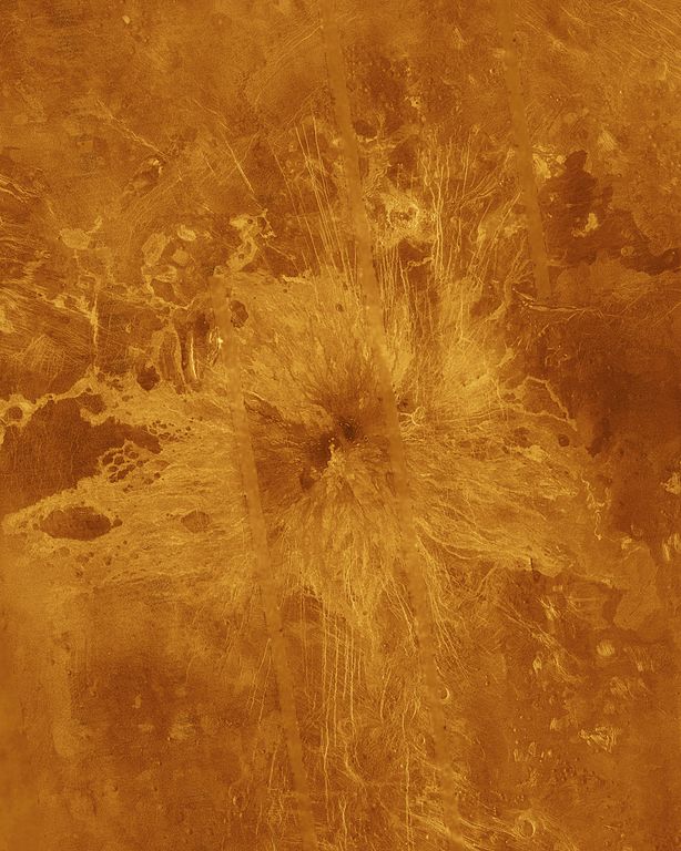
| الوصف | Ushas Mons, a 2-kilometer-high (1.25 mile) volcano in the southern hemisphere of Venus is shown in this Magellan radar image. The image is centered at 25 degrees south latitude, 323 degrees east longitude, and shows an area approximately 600 kilometers (360 miles) on a side. The volcano is marked by numerous bright lava flows and a set of north-south trending fractures, many of which appear to have formed after the lavas were erupted onto the surface. In the central summit area, however, younger flows remain unfractured. An impact crater can be seen among the fractures in the upper center of the image. The association of faulting and volcanism is common on this type of volcano on Venus, and is believed to result from a large zone of hot material upwelling from the Venusian mantle, a phenomenon known on Earth as a "hot spot." Simulated color is used to enhance small-scale structures. The simulated hues are based on color images recorded by the Venera 13 and 14 landing craft. The data were acquired during the third eight-month cycle of Magellan's radar mapping, which ended in September 1992. Several narrow gaps in the Magellan coverage are filled with low-resolution radar data obtained by the Earth-based Arecibo radio telescope. The image was produced by the Solar System Visualization Project and the Magellan Science Team at the Jet Propulsion Multimission Image Processing Laboratory. The Magellan mission is managed by JPL for NASA's Office of Space Science. |
| المصدر | http://photojournal.jpl.nasa.gov/catalog/PIA00272 |
| المؤلف | JPL/NASA |
فُهرِست هذه الصُّورة أَو هذا التَّسجيل المرئي لدى Jet Propulsion Laboratory التَّابعة لوكالة الفضاء الأَمريكيَّة (ناسا) تحت المُعرِّف PIA00272. لا يُشير هذه الوَسم إلى حالة حقوق التَّأليف والنَّشر الخاصَّة بالعمل المُرفَق؛ لا يزال وَسم حقوق التَّأليف والنَّشر مَطلُوباً، راجع كومنز:ترخيص لمزيدٍ من المعلومات. لغات أخرى:
|
ترخيص
| يقع هذا العمل في النِّطاق العامّ في الولايات المُتحدة الأمريكيَّة لأَنَّه عملٌ خالِصٌ من إِنتاج وكالة الفضاء الأمريكيَّة. تنصُ حقوق التَّأليف والنَّشر الخاصَّة بوكالة الفضاء الأمريكيَّة على أنَّ "أعمال الوكالة غير مَحميَّة بحقوق التَّأليف والنَّشر ما لم يُذكر خلافُ ذلك". لمزيدٍ من المعلومات انظر القالِب {{PD-USGov}} وصفحة حقوق التَّأليف والنَّشر الخاصَّة بالوكالة وصفحة سياسة الصُّور الخاصَّة بمُختبر الدَّفع النَّفَّاث. | ||
 |
تنبيهات:
|
تاريخ الملف
اضغط على زمن/تاريخ لرؤية الملف كما بدا في هذا الزمن.
| زمن/تاريخ | صورة مصغرة | الأبعاد | مستخدم | تعليق | |
|---|---|---|---|---|---|
| حالي | 17:32، 9 فبراير 2012 | | 4٬096 × 5٬120 (5٫17 ميجابايت) | Lotse | higher resolution |
| 23:48، 24 نوفمبر 2007 |  | 516 × 645 (47 كيلوبايت) | Lotse | {{Information |Description= Ushas Mons, a 2-kilometer-high (1.25 mile) volcano in the southern hemisphere of Venus is shown in this Magellan radar image. The image is centered at 25 degrees south latitude, 323 degrees east longitude, and shows an area |
استخدام الملف
الصفحة التالية تستخدم هذا الملف:
الاستخدام العالمي للملف
الويكيات الأخرى التالية تستخدم هذا الملف:
- الاستخدام في de.wikipedia.org
- الاستخدام في en.wikipedia.org
- الاستخدام في es.wikipedia.org
- الاستخدام في fr.wikipedia.org
- الاستخدام في gl.wikipedia.org
- الاستخدام في it.wikipedia.org
- الاستخدام في nl.wikipedia.org
- الاستخدام في pt.wikipedia.org
- الاستخدام في uk.wikipedia.org
- الاستخدام في www.wikidata.org
- الاستخدام في zh.wikipedia.org