ملف:Topo Map Pennines.png
الملف الأصلي (1٬250 × 1٬803 بكسل حجم الملف: 3٫2 ميجابايت، نوع MIME: image/png)
| هذا ملف من ويكيميديا كومنز. معلومات من صفحة وصفه مبينة في الأسفل. كومنز مستودع ملفات ميديا ذو رخصة حرة. |
ملخص
| الوصف |
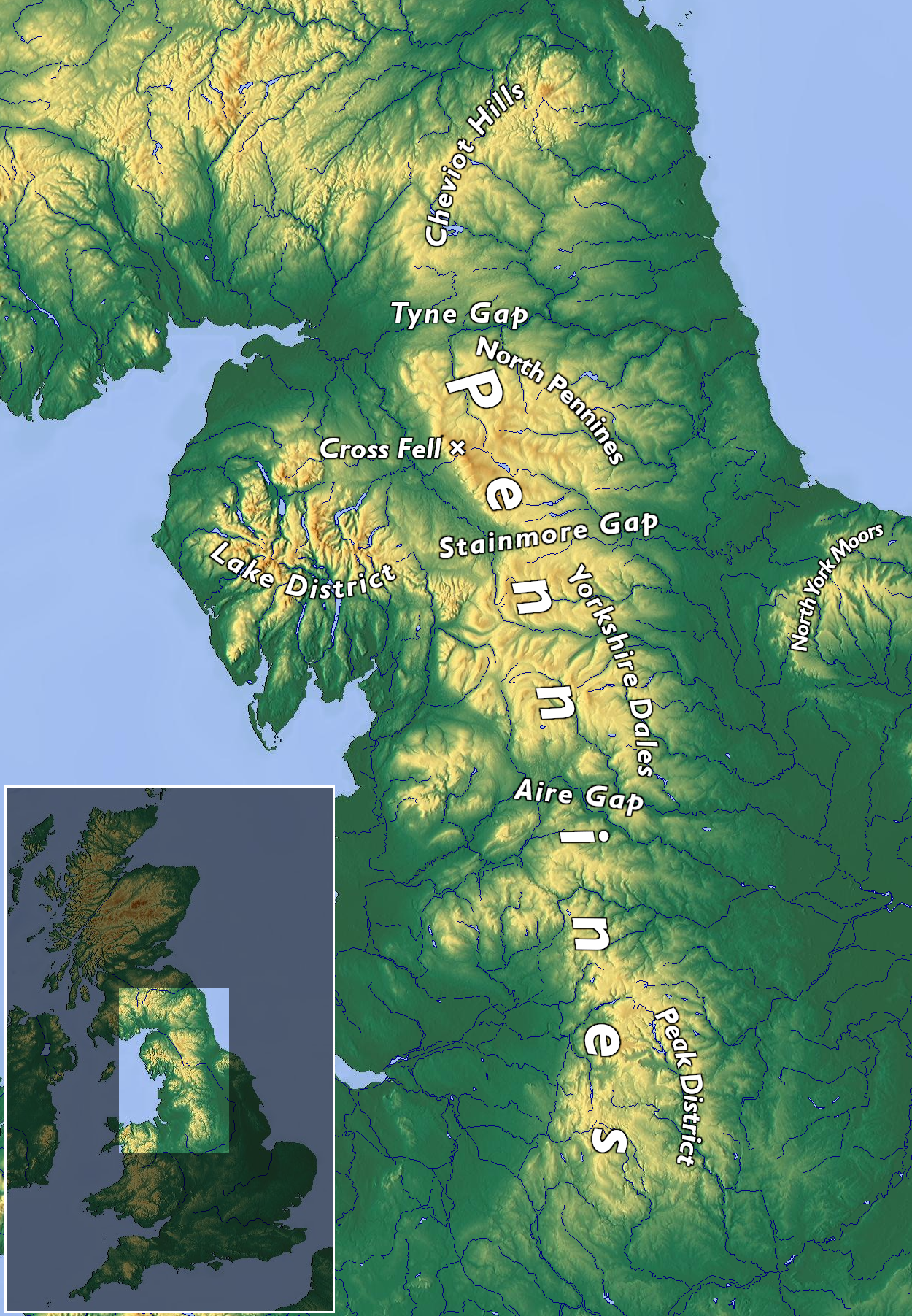
English: Topographic map of the Pennines
Deutsch: Topographische Karte der Pennines |
|||||||||
| التاريخ | ||||||||||
| المصدر | عمل شخصي | |||||||||
| المؤلف | Kreuzschnabel, basemap from maps-for-free, CC0 licensed | |||||||||
| الترخيص (إعادة استخدام هذا الملف) |
أنا، صاحب حقوق التأليف والنشر لهذا العمل، أنشر هذا العمل تحت الرخصة التالية: هذا الملفُّ مُرخَّص بموجب رخصة المشاع الإبداعي نسبة المُصنَّف إِلى مُؤَلِّفه - المشاركة بالمثل 3.0 العامة
|


تاريخ الملف
اضغط على زمن/تاريخ لرؤية الملف كما بدا في هذا الزمن.
| زمن/تاريخ | صورة مصغرة | الأبعاد | مستخدم | تعليق | |
|---|---|---|---|---|---|
| حالي | 09:09، 25 سبتمبر 2020 | | 1٬250 × 1٬803 (3٫2 ميجابايت) | Kreuzschnabel | + North Pennines |
| 16:43، 20 يونيو 2020 |  | 1٬250 × 1٬803 (3٫19 ميجابايت) | Kreuzschnabel | labels readability improved | |
| 09:49، 20 يونيو 2020 |  | 1٬250 × 1٬803 (3٫17 ميجابايت) | Kreuzschnabel | {{Information |description ={{en|1=Topographic map of the Pennines}} {{de|1=Topographische Karte der Pennines}} |date =2020-06-20 |source ={{own}} |author =User:Kreuzschnabel, basemap from maps-for-free, CC0 licensed |permission ={{subst:User:Kreuzschnabel/Lizenz}} }} Category:Maps of the United Kingdom Category:Pennines (hills) Category:Images by Kreuzschnabel/Karten und Grafiken |
استخدام الملف
الصفحة التالية تستخدم هذا الملف:
الاستخدام العالمي للملف
الويكيات الأخرى التالية تستخدم هذا الملف:
- الاستخدام في de.wikipedia.org
- الاستخدام في el.wikipedia.org
- الاستخدام في en.wikipedia.org
- الاستخدام في es.wikipedia.org
- الاستخدام في fr.wikipedia.org
- الاستخدام في gl.wikipedia.org
- الاستخدام في nl.wikipedia.org