ملف:Taupo.Volcanic.Zone.North.Island.NZ.JPG
الملف الأصلي (616 × 864 بكسل حجم الملف: 104 كيلوبايت، نوع MIME: image/jpeg)
| هذا ملف من ويكيميديا كومنز. معلومات من صفحة وصفه مبينة في الأسفل. كومنز مستودع ملفات ميديا ذو رخصة حرة. |
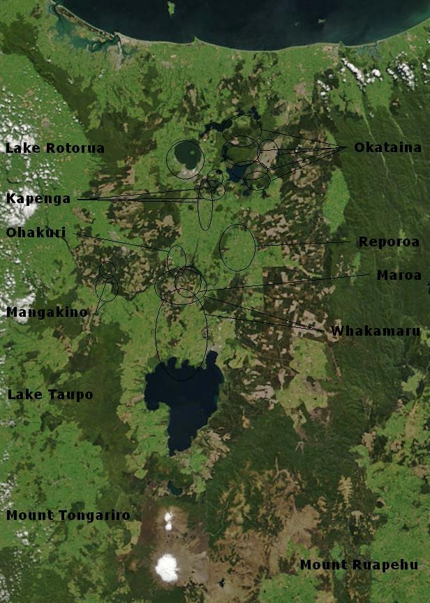
| الوصف | Bay of Plenty, North Island, New Zealand, from the Bay of Plenty coast to Mounts Tongariro, Ngauruhoe, and Ruapehu (at bottom of picture). Also shows Lake Taupo and the Rotorua Lakes. This scene was acquired by the Moderate Resolution Imaging Spectroradiometer (MODIS), flying aboard NASA’s Terra satellite, on October 23, 2002 |
| التاريخ | (UTC) |
| المصدر | |
| المؤلف |
|
Annotations based on: Hiess J, Cole JW, Spinks KD (2007), High-Alumina Basalts of the Taupo Volcanic Zone, New Zealand: Influence of the Crust and Crustal Structure [1]; Krippner SJP, Briggs RM, Wilson CJN, Cole JW (1998), Petrography and geochemistry of lithic fragments in ignimbrites from the Mangakino Volcanic Centre: implications for the composition of the subvolcanic crust in western Taupo Volcanic Zone, New Zealand; New Zealand Journal of Geology and Geophysics, Vol. 41: 187-199 [2] نسخة مؤرشفة at the Wayback Machine; Newhall, Christopher G.; Dzurisin, Daniel (1988), Historical unrest at large calderas of the world, USGS Bulletin 1855, p. 1108 [3] نسخة مؤرشفة at the Wayback Machine; Siebert L, Simkin T (2002-), Volcanoes of the World: an Illustrated Catalog of Holocene Volcanoes and their Eruptions, Smithsonian Institution, Global Volcanism Program Digital Information Series, GVP-3 [4]
| يقع هذا العمل في النِّطاق العامّ في الولايات المُتحدة الأمريكيَّة لأَنَّه عملٌ خالِصٌ من إِنتاج وكالة الفضاء الأمريكيَّة. تنصُ حقوق التَّأليف والنَّشر الخاصَّة بوكالة الفضاء الأمريكيَّة على أنَّ "أعمال الوكالة غير مَحميَّة بحقوق التَّأليف والنَّشر ما لم يُذكر خلافُ ذلك". لمزيدٍ من المعلومات انظر القالِب {{PD-USGov}} وصفحة حقوق التَّأليف والنَّشر الخاصَّة بالوكالة وصفحة سياسة الصُّور الخاصَّة بمُختبر الدَّفع النَّفَّاث. | ||
 |
تنبيهات:
|
سجلُّ الرَّفع الأصيل
This image is a derivative work of the following images:
- File:BayofPlentyA2002296.jpg licensed with PD-USGov-NASA
- 2007-08-24T00:20:45Z Kahuroa 616x864 (505144 Bytes) == Summary == {{Information |Description=Bay of Plenty, North Island, New Zealand, from the Bay of Plenty coast to Mounts Tongariro, Ngauruhoe, and Ruapehu (at bottom of picture). Also shows Lake Taupo and the Rotorua Lakes.
Uploaded with derivativeFX
تاريخ الملف
اضغط على زمن/تاريخ لرؤية الملف كما بدا في هذا الزمن.
| زمن/تاريخ | صورة مصغرة | الأبعاد | مستخدم | تعليق | |
|---|---|---|---|---|---|
| حالي | 02:17، 20 فبراير 2010 | | 616 × 864 (104 كيلوبايت) | Chris.urs-o | One label was missing. |
| 01:49، 20 فبراير 2010 |  | 616 × 864 (103 كيلوبايت) | Chris.urs-o | Fixed label | |
| 10:42، 19 فبراير 2010 |  | 616 × 864 (105 كيلوبايت) | Chris.urs-o | Improved caldera locations | |
| 11:20، 18 فبراير 2010 |  | 616 × 864 (103 كيلوبايت) | Chris.urs-o | {{Information |Description=Bay of Plenty, North Island, New Zealand, from the Bay of Plenty coast to Mounts Tongariro, Ngauruhoe, and Ruapehu (at bottom of picture). Also shows Lake Taupo and the Rotorua Lakes. This scene was acquired by the Moderate Reso |
استخدام الملف
الصفحة التالية تستخدم هذا الملف:
الاستخدام العالمي للملف
الويكيات الأخرى التالية تستخدم هذا الملف:
- الاستخدام في de.wikipedia.org
- الاستخدام في en.wikipedia.org
- الاستخدام في en.wikiversity.org
- الاستخدام في es.wikipedia.org
- الاستخدام في fi.wikipedia.org
- الاستخدام في id.wikipedia.org
- الاستخدام في it.wikipedia.org
- الاستخدام في mk.wikipedia.org
- الاستخدام في ru.wikipedia.org
- الاستخدام في simple.wikipedia.org
- الاستخدام في sl.wikipedia.org
- الاستخدام في uk.wikipedia.org