ملف:Ptolemaic-Empire 200bc.jpg
الملف الأصلي (1٬164 × 636 بكسل حجم الملف: 1٫02 ميجابايت، نوع MIME: image/jpeg)
| هذا ملف من ويكيميديا كومنز. معلومات من صفحة وصفه مبينة في الأسفل. كومنز مستودع ملفات ميديا ذو رخصة حرة. |

|
هذه historical map الصورة / الصورتان باستعمال رسومات متجهية ملفات رسوميات شعاعية.
It is recommended to name the SVG file "Ptolemaic-Empire 200bc.svg" - then the template Vector version available (or Vva) does not need the new image name parameter.
|


ملخص
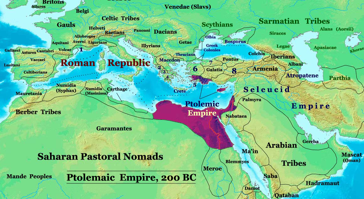
| الوصف | The Ptolemaic Kingdom of Egypt in 200 BC. |
| المصدر | عمل شخصي |
| المؤلف | Thomas Lessman (Contact!) |
| الترخيص (إعادة استخدام هذا الملف) |
أنا، صاحب حقوق التأليف والنشر لهذا العمل، أنشر هذا العمل تحت الرخصة التالية: هذا الملفُّ مُرخَّص بموجب رخصة المشاع الإبداعي نسبة المُصنَّف إِلى مُؤَلِّفه - المشاركة بالمثل 3.0 العامة
|
| إصدارات أخرى |
أَعمالٌ مُشتقَّة مِن هذا الملفِّ: Ptolemaic-Empire 200bcARABIC.JPG see below |
Author: Thomas A. Lessman. Source URL: http://www.ThomasLessman.com/History/images/East-Hem_200bc.jpg. Image was created by me (Thomas Lessman) based on my map of Eastern Hemisphere in 200 BC.
Map Summary

Original Source URL: http://www.thomaslessman.com/History/images/East-Hem_200bc.jpg
This map is a zoomed-in version of Thomas Lessman's map of the
East-Hem 200bc.jpg (also available at www.WorldHistoryMaps.info).
Highlighted areas represent lands of the Ptolemaic Kingdom of Egypt in the year 200 BC, during the reign of Ptolemy V Epiphanes (before the 2nd invasion of Antiochus III).
Map Source References
Remember, sources often conflict with each other. This map is only as accurate as the information that is available to me. To report any errors or to help further this work, please click here, or email Thomas Lessman at talessman@yis.us
References for information contained in this map:
Other Maps by Thomas Lessman
| Maps of the eastern hemisphere showing history
Bold dates are available on Wikimedia or Wikipedia. | ||
| Primeval | ||
| Ancient
|
·| 600 BC | 550 BC | 527 BC | 500 BC |
400 BC | ·| 1 AD | 50 AD | 100 AD | 200 AD | 300 AD | | |
| Medieval |
·| 500 AD | 565 AD | 600 AD | 700 AD | | |
| Modern |
·| 1500 AD | · * For historical maps of the whole world, | |
Other Info
تاريخ الملف
اضغط على زمن/تاريخ لرؤية الملف كما بدا في هذا الزمن.
| زمن/تاريخ | صورة مصغرة | الأبعاد | مستخدم | تعليق | |
|---|---|---|---|---|---|
| حالي | 20:06، 3 فبراير 2010 | | 1٬164 × 636 (1٫02 ميجابايت) | Malus Catulus | I missed a spot |
| 20:01، 3 فبراير 2010 |  | 1٬164 × 636 (1 ميجابايت) | Malus Catulus | Removed redundant info according to commons norms | |
| 08:15، 20 مايو 2008 |  | 1٬164 × 636 (886 كيلوبايت) | Talessman | {{Information |Description= |Source=self-made |Date= |Author= Talessman |Permission= |other_versions= }} Category:Hellenistic age Category:Maps of Asian history Category:Maps of Ancient Greece Category:Seleucid dynasty |
استخدام الملف
الصفحتان التاليتان تستخدمان هذا الملف:
الاستخدام العالمي للملف
الويكيات الأخرى التالية تستخدم هذا الملف:
- الاستخدام في ast.wikipedia.org
- الاستخدام في be.wikipedia.org
- الاستخدام في bg.wikipedia.org
- الاستخدام في de.wikipedia.org
- الاستخدام في el.wikipedia.org
- الاستخدام في en.wikipedia.org
- الاستخدام في eo.wikipedia.org
- الاستخدام في es.wikipedia.org
- الاستخدام في fa.wikipedia.org
- الاستخدام في fr.wikipedia.org
- الاستخدام في gl.wikipedia.org
- الاستخدام في he.wikipedia.org
- الاستخدام في hu.wikipedia.org
- الاستخدام في hy.wikipedia.org
- الاستخدام في hyw.wikipedia.org
- الاستخدام في id.wikipedia.org
- الاستخدام في it.wikipedia.org
- الاستخدام في ja.wikipedia.org
- الاستخدام في ko.wikipedia.org
- الاستخدام في la.wikipedia.org
- الاستخدام في lt.wikipedia.org
- الاستخدام في mg.wikipedia.org
- الاستخدام في ms.wikipedia.org
- الاستخدام في no.wikipedia.org
- الاستخدام في pnb.wikipedia.org
- الاستخدام في pt.wikipedia.org
- الاستخدام في ru.wikipedia.org
- الاستخدام في sco.wikipedia.org
- الاستخدام في sh.wikipedia.org
- الاستخدام في sl.wikipedia.org
- الاستخدام في sr.wikipedia.org
- الاستخدام في sv.wikipedia.org
اعرض المزيد من الاستخدام العام لهذا الملف.