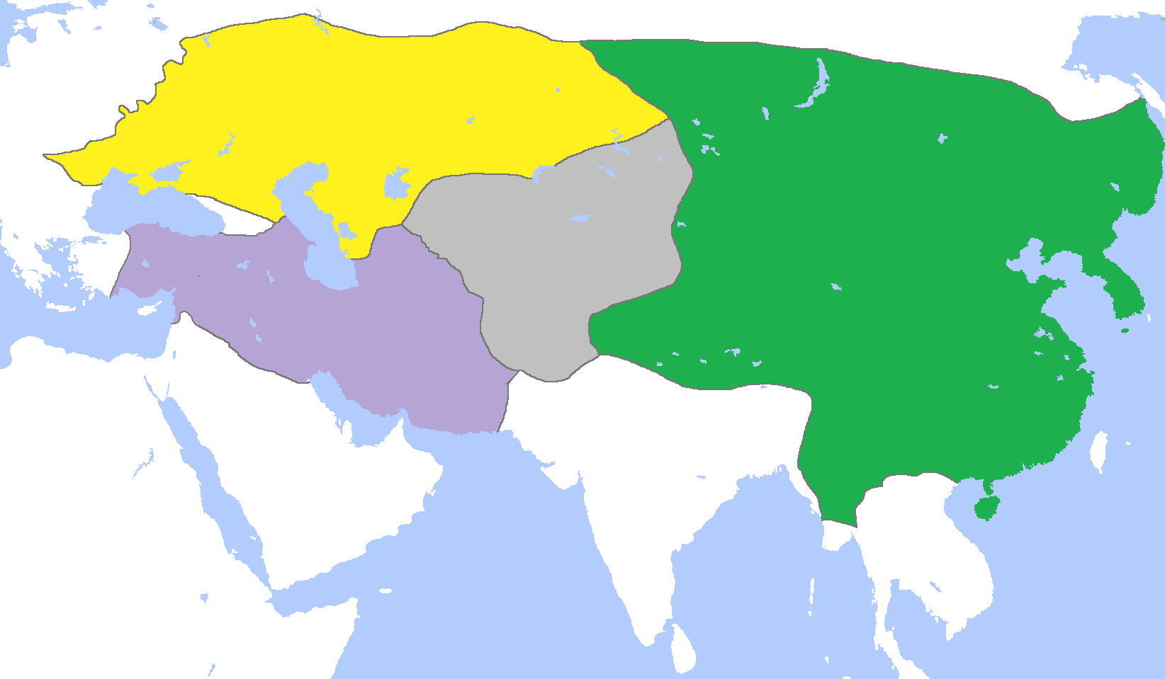
ملف:MongolEmpireDivisions1300.png
حجم هذه المعاينة: 800 × 467 بكسل. الأبعاد الأخرى: 320 × 187 بكسل | 640 × 373 بكسل | 1٬024 × 597 بكسل | 1٬644 × 959 بكسل.
الملف الأصلي (1٬644 × 959 بكسل حجم الملف: 37 كيلوبايت، نوع MIME: image/png)
| هذا ملف من ويكيميديا كومنز. معلومات من صفحة وصفه مبينة في الأسفل. كومنز مستودع ملفات ميديا ذو رخصة حرة. |
ملخص
| الوصف |
English: Map of the Mongol Empire c. 1300, after its four subdivisions into the:
Français : Carte des Divisions de l'Empire mongol vers 1300 :
|
| التاريخ | |
| المصدر | عمل شخصي |
| المؤلف | Gabagool |
ترخيص
أنا، صاحب حقوق التأليف والنشر لهذا العمل، أنشر هذا العمل تحت الرخصة التالية:
هذا الملف مُرخص تحت رخصة المشاع المبدع نسبة المصنف إلى مؤلفه 3.0 العامة
- يحقُّ لك:
- مشاركة العمل – نسخ العمل وتوزيعه وبثُّه
- إعادة إنتاج العمل – تعديل العمل
- حسب الشروط التالية:
- نسب العمل إلى مُؤَلِّفه – يلزم نسب العمل إلى مُؤَلِّفه بشكل مناسب وتوفير رابط للرخصة وتحديد ما إذا أجريت تغييرات. بالإمكان القيام بذلك بأية طريقة معقولة، ولكن ليس بأية طريقة تشير إلى أن المرخِّص يوافقك على الاستعمال.
تاريخ الملف
اضغط على زمن/تاريخ لرؤية الملف كما بدا في هذا الزمن.
| زمن/تاريخ | صورة مصغرة | الأبعاد | مستخدم | تعليق | |
|---|---|---|---|---|---|
| حالي | 15:40، 26 أغسطس 2023 | | 1٬644 × 959 (37 كيلوبايت) | Ecthelion83 | Tsushima was never under Mongol control and was never a vassal state to the Mongols |
| 15:59، 16 نوفمبر 2022 |  | 1٬644 × 959 (48 كيلوبايت) | Gyalu22 | Reverted to version as of 01:33, 29 July 2015 (UTC) | |
| 12:02، 4 يونيو 2018 |  | 1٬644 × 959 (29 كيلوبايت) | Julieta39 | No Golden Horde rule on the Theodoro principality (South Crimea) | |
| 11:35، 4 يونيو 2018 |  | 1٬644 × 959 (29 كيلوبايت) | Julieta39 | Shorelines, no modern dam lakes, Galicia and Hungary out of the Golden Horde rule, Trebizond Empire out of the Ilkhans rule. | |
| 01:33، 29 يوليو 2015 |  | 1٬644 × 959 (48 كيلوبايت) | History of Persia | The ilkhans controlled anatolia | |
| 01:44، 5 أغسطس 2014 |  | 1٬644 × 959 (61 كيلوبايت) | Tm | Reverted to version as of 11:52, 6 June 2013 reverting persistent vandalism. As you were told before upload your version under a new filename | |
| 00:51، 5 أغسطس 2014 |  | 1٬644 × 959 (38 كيلوبايت) | Flamarial~commonswiki | As vassal states are not included in territories due to widespread cartographic convention, reverted to an earlier version to account for this. The Kingdom of Goryeo was instead a compulsory ally and vassal state of the Mongol Empire, not directly anne... | |
| 00:47، 5 أغسطس 2014 |  | 1٬644 × 959 (61 كيلوبايت) | Tm | Reverted to version as of 11:52, 6 June 2013 | |
| 16:49، 4 أغسطس 2014 |  | 1٬644 × 959 (38 كيلوبايت) | Flamarial~commonswiki | As vassal states are not included in territories due to widespread cartographic convention, reverted to an earlier version to account for this. The Kingdom of Goryeo was a compulsory ally and vassal state of the Mongol Empire, but it was not directly a... | |
| 11:52، 6 يونيو 2013 |  | 1٬644 × 959 (61 كيلوبايت) | Tm | Reverted to version as of 18:40, 5 June 2013 Please read : http://commons.wikimedia.org/w/index.php?title=Commons:Village_pump&diff=33196237&oldid=33196194 and https://secure.wikimedia.org/wikipedia/commons/wiki/Commons:Village_pump#Edit_warring_ove |
استخدام الملف
ال3 صفحات التالية تستخدم هذا الملف:
الاستخدام العالمي للملف
الويكيات الأخرى التالية تستخدم هذا الملف:
- الاستخدام في af.wikipedia.org
- الاستخدام في ast.wikipedia.org
- الاستخدام في azb.wikipedia.org
- الاستخدام في be-tarask.wikipedia.org
- الاستخدام في bn.wikipedia.org
- الاستخدام في ckb.wikipedia.org
- الاستخدام في en.wikipedia.org
- الاستخدام في en.wikivoyage.org
- الاستخدام في eo.wikipedia.org
- الاستخدام في es.wikipedia.org
- الاستخدام في et.wikipedia.org
- الاستخدام في eu.wikipedia.org
- الاستخدام في fa.wikipedia.org
- الاستخدام في fr.wikipedia.org
- الاستخدام في id.wikipedia.org
- الاستخدام في it.wikipedia.org
اعرض المزيد من الاستخدام العام لهذا الملف.