ملف:Map of IJsselmeer.png
لا توجد دقة أعلى متوفرة.
Map_of_IJsselmeer.png (247 × 303 بكسل حجم الملف: 14 كيلوبايت، نوع MIME: image/png)
| هذا ملف من ويكيميديا كومنز. معلومات من صفحة وصفه مبينة في الأسفل. كومنز مستودع ملفات ميديا ذو رخصة حرة. |
ملخص
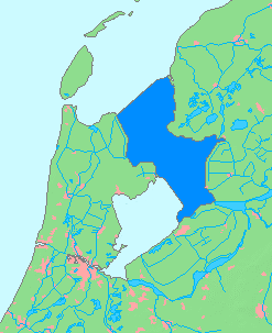
| الوصف |
English: Maps od Ijsselmeer, of Netherlands
日本語: オランダのアイセル湖の地図 |
| التاريخ | |
| المصدر | based on Image:MapNetherlandsWater.PNG |
| المؤلف | inoue-hiro |
ترخيص
This image is in the public domain because it came from the site https://www.demis.nl/products/web-map-server/examples/ and was released by the copyright holder. Permission is granted to copy, distribute and/or modify this map since it is based on free of copyright images from: www.demis.nl. See also approval email on de.wp and its clarification.
|
| This work has been released into the public domain by its copyright holder, www.demis.nl. This applies worldwide. في بعض البلدان، قد يكون هذا التَّرخيص غيرَ مُمكنٍ قانونيَّاً، في هذه الحالة: يمنح www.demis.nl الجميع حق استخدام هذا العمل لأي غرض دون أي شرط ما لم يفرض القانون شروطًا إضافية.
|
تاريخ الملف
اضغط على زمن/تاريخ لرؤية الملف كما بدا في هذا الزمن.
| زمن/تاريخ | صورة مصغرة | الأبعاد | مستخدم | تعليق | |
|---|---|---|---|---|---|
| حالي | 21:52، 16 مارس 2014 | | 247 × 303 (14 كيلوبايت) | Io Herodotus | removed the markenwaard |
| 04:02، 31 يناير 2009 |  | 247 × 303 (7 كيلوبايت) | Inoue-hiro | delete editing guideline remains | |
| 03:51، 31 يناير 2009 |  | 247 × 303 (7 كيلوبايت) | Inoue-hiro | {{Information |Description={{en|1=Maps od Ijsselmeer, of Netherlands}} {{ja|1=オランダのアイセル湖の地図}} |Source=based on Image:apNetherlandsWater.PNG |Author=inoue-hiro |Date=2009/01/31 |Permission= |other_versions= }} <!--{{ImageUpl |
استخدام الملف
لا توجد صفحات تستخدم هذا الملف.
الاستخدام العالمي للملف
الويكيات الأخرى التالية تستخدم هذا الملف:
- الاستخدام في be.wikipedia.org
- الاستخدام في en.wikipedia.org
- الاستخدام في es.wikipedia.org
- الاستخدام في fa.wikipedia.org
- الاستخدام في fi.wikipedia.org
- الاستخدام في fr.wikipedia.org
- الاستخدام في he.wikipedia.org
- الاستخدام في hr.wikipedia.org
- الاستخدام في hy.wikipedia.org
- الاستخدام في it.wikipedia.org
- الاستخدام في ja.wikipedia.org
- الاستخدام في li.wikipedia.org
- الاستخدام في lt.wikipedia.org
- الاستخدام في nl.wikipedia.org
- الاستخدام في nl.wiktionary.org
- الاستخدام في roa-tara.wikipedia.org
- الاستخدام في ru.wikipedia.org
- الاستخدام في sl.wikipedia.org
- الاستخدام في sr.wikipedia.org
- الاستخدام في th.wikipedia.org
- الاستخدام في vls.wikipedia.org
- الاستخدام في www.wikidata.org
- الاستخدام في zh.wikipedia.org