ملف:Map Cleomenean War-en.svg

حجم معاينة PNG لذلك الملف ذي الامتداد SVG: 431 × 542 بكسل. الأبعاد الأخرى: 191 × 240 بكسل | 382 × 480 بكسل | 611 × 768 بكسل | 814 × 1٬024 بكسل | 1٬628 × 2٬048 بكسل.
الملف الأصلي (ملف SVG، أبعاده 431 × 542 بكسل، حجم الملف: 982 كيلوبايت)
| هذا ملف من ويكيميديا كومنز. معلومات من صفحة وصفه مبينة في الأسفل. كومنز مستودع ملفات ميديا ذو رخصة حرة. |
ملخص
| الوصف |
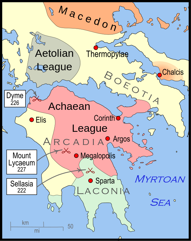
English: Mainland Greece during the time of the Cleomenean War, ca. 228 BCE |
| التاريخ | |
| المصدر | عمل شخصي |
| المؤلف | MapMaster |
| إصدارات أخرى |
[]
|


-pt.svg)


References
The map itself was built using File:Greece map blank.svg, adding the now-drained Lake Copais. Towns were placed using geographic coordinates.
The borders of the various political entities were taken from several sources:
- Chamoux, François (2002) Hellenistic civilization, Wiley-Blackwell, ISBN 9780631222422, p. 206, for the Achaean League. I did not use this for the Aetolian League, since this map shows the later and larger borders of the Aetolian League, after the Cleomenean War.
- Gabbert, Janice J. (1997) Antigonus II Gonatas: a political biography, Routledge, ISBN 9780415018999 , p. 33, for the area under the control of Macedon.
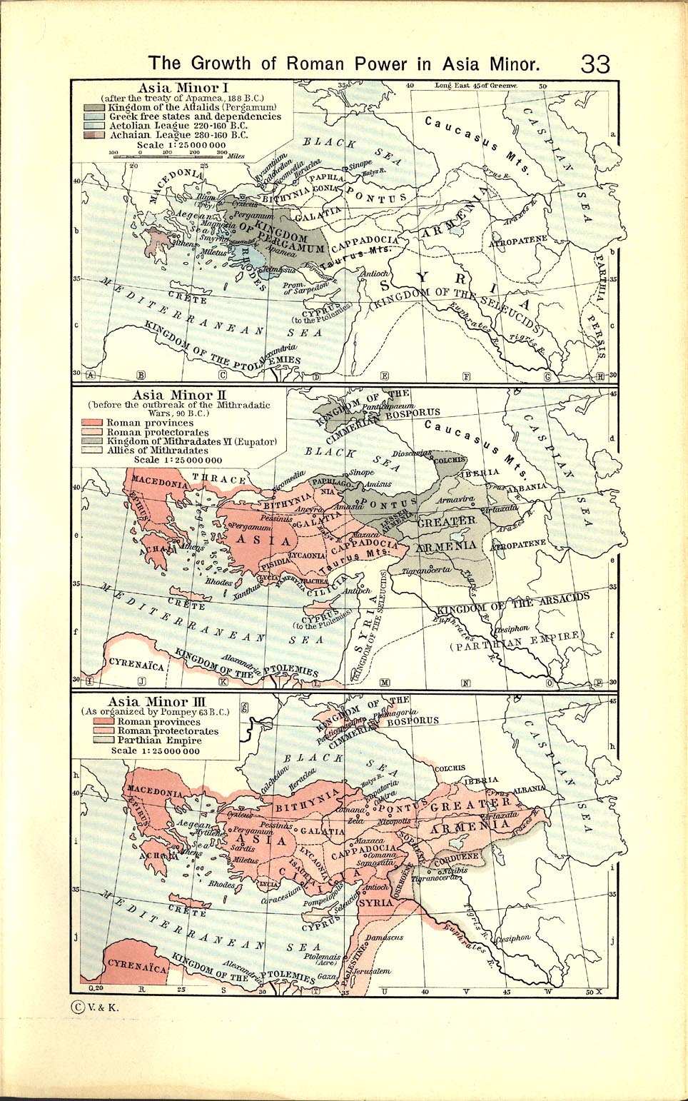
- Shepherd, William (1911) "The Growth of Roman Power in Asia Minor", Historical Atlas, Henry Holt and Company. p. 33, was used as the primary reference for the Aetolian League.
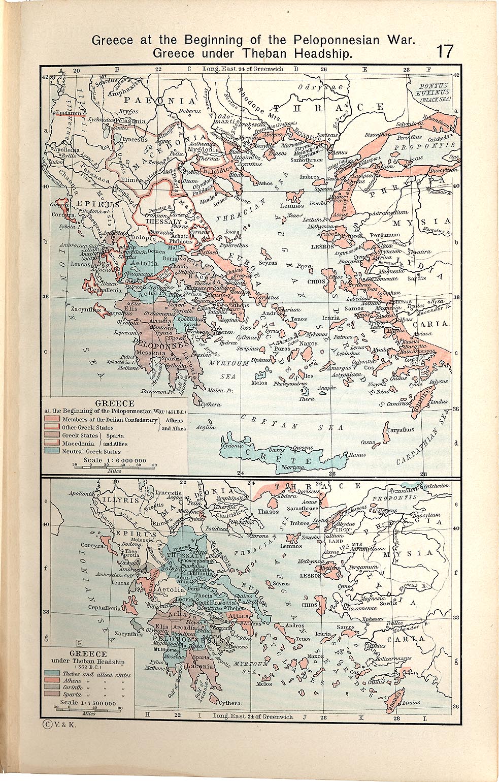
- Shepherd, William (1911) "Greece under Theban Headship", Historical Atlas, Henry Holt and Company. p. 17, was used as the primary reference for the Spartan borders. When there was a conflict with the Chamoux map, I used the Chamoux map.
Any additional information on borders and areas under control would be very welcome.
Similar maps

ترخيص
أنا، صاحب حقوق التأليف والنشر لهذا العمل، أنشر هذا العمل تحت الرخصة التالية:
هذا الملفُّ مُرخَّص بموجب رخصة المشاع الإبداعي نسبة المُصنَّف إِلى مُؤَلِّفه - المشاركة بالمثل 3.0 العامة
- يحقُّ لك:
- مشاركة العمل – نسخ العمل وتوزيعه وبثُّه
- إعادة إنتاج العمل – تعديل العمل
- حسب الشروط التالية:
- نسب العمل إلى مُؤَلِّفه – يلزم نسب العمل إلى مُؤَلِّفه بشكل مناسب وتوفير رابط للرخصة وتحديد ما إذا أجريت تغييرات. بالإمكان القيام بذلك بأية طريقة معقولة، ولكن ليس بأية طريقة تشير إلى أن المرخِّص يوافقك على الاستعمال.
- الإلزام بترخيص المُشتقات بالمثل – إذا أعدت إنتاج المواد أو غيرت فيها، فيلزم أن تنشر مساهماتك المُشتقَّة عن الأصل تحت ترخيص الأصل نفسه أو تحت ترخيص مُتوافِقٍ معه.
تاريخ الملف
اضغط على زمن/تاريخ لرؤية الملف كما بدا في هذا الزمن.
| زمن/تاريخ | صورة مصغرة | الأبعاد | مستخدم | تعليق | |
|---|---|---|---|---|---|
| حالي | 04:57، 12 يناير 2010 | | 431 × 542 (982 كيلوبايت) | MapMaster | {{Information |Description={{en|1=A map of Greece during the Cleomenean War}} |Source={{own}} |Author=MapMaster |Date=11 January 2010 |Permission= |other_versions= }} Category:Maps of the history of Greece |
استخدام الملف
الصفحة التالية تستخدم هذا الملف:
الاستخدام العالمي للملف
الويكيات الأخرى التالية تستخدم هذا الملف:
- الاستخدام في bg.wikipedia.org
- الاستخدام في ca.wikipedia.org
- الاستخدام في el.wikipedia.org
- الاستخدام في en.wikipedia.org
- الاستخدام في et.wikipedia.org
- الاستخدام في he.wikipedia.org
- الاستخدام في it.wikipedia.org
- الاستخدام في ja.wikipedia.org
- الاستخدام في ko.wikipedia.org
- الاستخدام في nl.wikipedia.org
- الاستخدام في sh.wikipedia.org
- الاستخدام في tr.wikipedia.org
- الاستخدام في uk.wikipedia.org
- الاستخدام في vi.wikipedia.org
- الاستخدام في www.wikidata.org
- الاستخدام في zh.wikipedia.org