ملف:Israel and the Disputed Territories map.png

الملف الأصلي (1٬350 × 2٬300 بكسل حجم الملف: 1٫39 ميجابايت، نوع MIME: image/png)
| هذا ملف من ويكيميديا كومنز. معلومات من صفحة وصفه مبينة في الأسفل. كومنز مستودع ملفات ميديا ذو رخصة حرة. |
ملخص
| الوصف |
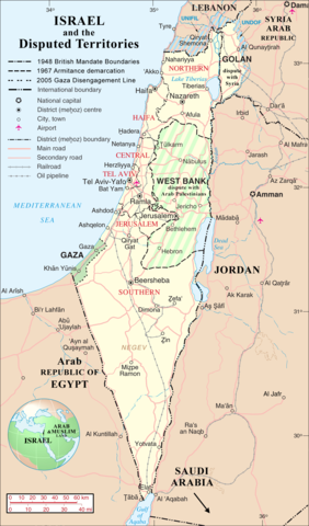
English: Map of Israel, Palestinian Controlled Territories of (Gaza and the West Bank), the Golan Heights, and neighbouring countries. Also United Nations deployment, as of January 2004, in the area. |
|||
| التاريخ | ||||
| المصدر | http://www.un.org/Depts/Cartographic/map/profile/israel.pdf (heavily modified) | |||
| المؤلف | Jaakobou | |||
| الترخيص (إعادة استخدام هذا الملف) |
|

| الشروح | هذه الصورة مشروحة: أظهر الشروح في كومنز |
تاريخ الملف
اضغط على زمن/تاريخ لرؤية الملف كما بدا في هذا الزمن.
| زمن/تاريخ | صورة مصغرة | الأبعاد | مستخدم | تعليق | |
|---|---|---|---|---|---|
| حالي | 18:03، 1 أبريل 2007 | | 1٬350 × 2٬300 (1٫39 ميجابايت) | Jaakobou | == Summary == {{Information |Description= {{en|Map of Israel, [http://en.wikipedia.org/wiki/Palestinian_territories Palestinian Controlled Territories of] (Gaza and the West Bank), the Golan Heights, and neighbouring countries. |
استخدام الملف
الصفحة التالية تستخدم هذا الملف:
الاستخدام العالمي للملف
الويكيات الأخرى التالية تستخدم هذا الملف:
- الاستخدام في de.wikinews.org
- الاستخدام في en.wikipedia.org
- الاستخدام في he.wikipedia.org
- الاستخدام في nl.wikipedia.org
- الاستخدام في sq.wikipedia.org
- الاستخدام في uk.wikipedia.org
- الاستخدام في zea.wikipedia.org