ملف:International E Road Network green.png

حجم هذه المعاينة: 800 × 571 بكسل. البعدان الآخران: 320 × 229 بكسل | 640 × 457 بكسل.
الملف الأصلي (840 × 600 بكسل حجم الملف: 38 كيلوبايت، نوع MIME: image/png)
| هذا ملف من ويكيميديا كومنز. معلومات من صفحة وصفه مبينة في الأسفل. كومنز مستودع ملفات ميديا ذو رخصة حرة. |

|
هذه road map الصورة / الصورتان باستعمال رسومات متجهية ملفات رسوميات شعاعية.
It is recommended to name the SVG file "International E Road Network green.svg" - then the template Vector version available (or Vva) does not need the new image name parameter.
|
ملخص
| الوصف |
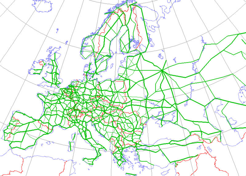
English: Map generated using coastline/boundary data from World Data Bank, and locations from http://www.world-gazetteer.com/. Straight lines connect control cities, no attempt to follow the real road. Roads color has been changed to green.
Deutsch: Diese Karte wurde mit den Küsten- und Grenzverlaufsdaten aus der World Data Bank und mit den Koordinaten aus http://www.world-gazetteer.com/ erstellt. Die Städte sind durch gerade Linien vebunden die nicht unbedingt den realen Straßenverlauf wiedergeben. Die Farbe der Straßen wurde in grün geändert.
Türkçe: Harita oluşturulken sahilyolu ve sınırlar bilgisi Dünya Bilgi Bankası'ndan ve lokasyonlar http://www.world-gazetteer.com/ adlı siteden alınmıştır. Düz çizgiler kontrol şehirlerini bağlar. Yol rengi yeşile değiştirildi. |
| المصدر | http://en.wikipedia.org/wiki/Image:International_E_Road_Network.png |
| المؤلف | Kjhskj75 |
ترخيص
| أنا، مالِك حقوق تأليف ونشر هذا العمل، أجعله في النِّطاق العامِّ، يسري هذا في أرجاء العالم كلِّه. في بعض البلدان، قد يكون هذا التَّرخيص غيرَ مُمكنٍ قانونيَّاً، في هذه الحالة: أمنح الجميع حق استخدام هذا العمل لأي غرض دون أي شرط ما لم يفرض القانون شروطًا إضافية. |
تاريخ الملف
اضغط على زمن/تاريخ لرؤية الملف كما بدا في هذا الزمن.
| زمن/تاريخ | صورة مصغرة | الأبعاد | مستخدم | تعليق | |
|---|---|---|---|---|---|
| حالي | 16:09، 13 مايو 2008 | | 840 × 600 (38 كيلوبايت) | Jklamo | Albania update |
| 12:07، 22 ديسمبر 2007 |  | 840 × 600 (39 كيلوبايت) | BIL | == Description == {{Information |Description=Map generated using coastline/boundary data from World Data Bank, and locations from www.world-gazetteer.com. Straight lines connect control cities, no attempt to follow the real road. Roads color has been chan | |
| 20:03، 7 أكتوبر 2007 |  | 840 × 600 (33 كيلوبايت) | The RedBurn | All e-roads in green. | |
| 19:55، 7 أكتوبر 2007 |  | 840 × 600 (34 كيلوبايت) | The RedBurn | {{Information |Description=Map generated using coastline/boundary data from World Data Bank, and locations from www.world-gazetteer.com. Straight lines connect control cities, no attempt to follow the real road. Roads color has been changed to green. |Sou |
استخدام الملف
الصفحتان التاليتان تستخدمان هذا الملف:
الاستخدام العالمي للملف
الويكيات الأخرى التالية تستخدم هذا الملف:
- الاستخدام في be.wikipedia.org
- الاستخدام في bg.wikipedia.org
- Европейски път
- Европейски път Е79
- Европейски път Е70
- Европейски път Е80
- Европейски път Е67
- Европейски път Е85
- Европейски път Е851
- Европейски път Е671
- Шаблон:Европейска пътна мрежа
- Европейски път Е81
- Европейски път Е804
- Европейски път Е763
- Европейски път Е762
- Европейски път Е87
- Европейски път Е772
- Европейски път Е83
- Европейски път Е871
- Европейски път Е75
- Европейски път Е773
- Европейски път Е11
- Европейски път Е51
- Европейски път Е761
- Европейски път Е17
- Европейски път Е76
- Европейски път Е82
- Европейски път Е84
- Европейски път Е86
- Европейски път E01
- Европейски път E03
- Европейски път E04
- Европейски път E05
- Европейски път E06
- Европейски път E07
- Европейски път E08
- Европейски път E09
- Европейски път E10
- Европейски път E12
- Европейски път E13
- Европейски път E14
- Европейски път E15
- Европейски път E16
اعرض المزيد من الاستخدام العام لهذا الملف.