ملف:Indian stream map.png
حجم هذه المعاينة: 800 × 575 بكسل. الأبعاد الأخرى: 320 × 230 بكسل | 640 × 460 بكسل | 1٬024 × 736 بكسل | 1٬280 × 920 بكسل | 1٬617 × 1٬162 بكسل.
الملف الأصلي (1٬617 × 1٬162 بكسل حجم الملف: 147 كيلوبايت، نوع MIME: image/png)
| هذا ملف من ويكيميديا كومنز. معلومات من صفحة وصفه مبينة في الأسفل. كومنز مستودع ملفات ميديا ذو رخصة حرة. |
ملخص
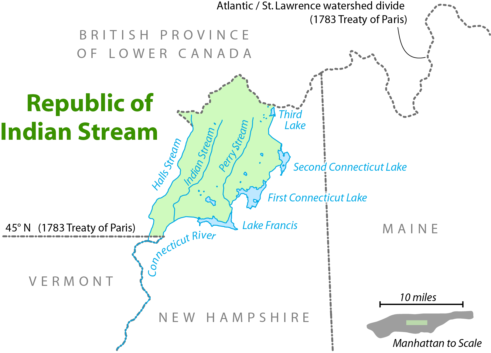
| الوصف | Map showing the location of the Republic of Indian Stream. I, Citynoise, am the creator of this map and hereby release it under the ShareAlike Attribution License. See www.radicalcartography.net for more. |
| التاريخ | ١٨ يونيو ٢٠٠٦ (تاريخ الرفع الأصيل) |
| المصدر | نُقِلت من en.wikipedia إلى كُومُنز . |
| المؤلف |
الرَّافِع الأصيل للملفِّ هو Citynoise في ويكيبيديا الإنجليزية. Later versions were uploaded by AnonMoos at en.wikipedia. |

|
هذه map الصورة / الصورتان باستعمال رسومات متجهية ملفات رسوميات شعاعية.
It is recommended to name the SVG file "Indian stream map.svg" - then the template Vector version available (or Vva) does not need the new image name parameter.
|
ترخيص
هذا الملف مُرخص تحت رخصة المشاع المبدع نسبة المصنف إلى مؤلفه - المشاركة على قدم المساواة 2.5 العامة
- يحقُّ لك:
- مشاركة العمل – نسخ العمل وتوزيعه وبثُّه
- إعادة إنتاج العمل – تعديل العمل
- حسب الشروط التالية:
- نسب العمل إلى مُؤَلِّفه – يلزم نسب العمل إلى مُؤَلِّفه بشكل مناسب وتوفير رابط للرخصة وتحديد ما إذا أجريت تغييرات. بالإمكان القيام بذلك بأية طريقة معقولة، ولكن ليس بأية طريقة تشير إلى أن المرخِّص يوافقك على الاستعمال.
- الإلزام بترخيص المُشتقات بالمثل – إذا أعدت إنتاج المواد أو غيرت فيها، فيلزم أن تنشر مساهماتك المُشتقَّة عن الأصل تحت ترخيص الأصل نفسه أو تحت ترخيص مُتوافِقٍ معه.
سجلُّ الرَّفع الأصيل
صفحة الوصف الأصلية كانت هنا، تشير جميع أسماء المستخدمين التالية إلى en.wikipedia.
- 2006-09-28 11:01 AnonMoos 754×548×8 (92671 bytes) trimming excessive margins (whitespace), increasing PNG compression...
- 2006-06-27 00:48 Citynoise 800×600×8 (115636 bytes) fixed error in date of Treaty of Paris.
- 2006-06-18 03:09 Citynoise 800×600×8 (119474 bytes) Map showing the location of the Republic of Indian Stream. I, Citynoise, am the creator of this map and hereby release it under the ShareAlike Attribution License. See www.radicalcartography.net for more. Added scale.
- 2006-06-18 02:43 Citynoise 800×588×8 (118009 bytes) Map showing the location of the Republic of Indian Stream. I, Citynoise, am the creator of this map and hereby release it under the ShareAlike Attribution License. See www.radicalcartography.net for more.
تاريخ الملف
اضغط على زمن/تاريخ لرؤية الملف كما بدا في هذا الزمن.
| زمن/تاريخ | صورة مصغرة | الأبعاد | مستخدم | تعليق | |
|---|---|---|---|---|---|
| حالي | 17:56، 6 سبتمبر 2016 | | 1٬617 × 1٬162 (147 كيلوبايت) | Citynoise | Corrected name of Lower Canada |
| 17:03، 10 أبريل 2007 |  | 754 × 548 (90 كيلوبايت) | Liftarn | {{Information |Description=Map showing the location of the Republic of Indian Stream. I, Citynoise, am the creator of this map and hereby release it under the ShareAlike Attribution License. See www.radicalcartography.net for more. |Source=Originally fr |
استخدام الملف
الصفحة التالية تستخدم هذا الملف:
الاستخدام العالمي للملف
الويكيات الأخرى التالية تستخدم هذا الملف:
- الاستخدام في bn.wikipedia.org
- الاستخدام في de.wikipedia.org
- الاستخدام في en.wikipedia.org
- الاستخدام في en.wiktionary.org
- الاستخدام في es.wikipedia.org
- الاستخدام في et.wikipedia.org
- الاستخدام في fr.wikipedia.org
- الاستخدام في ja.wikipedia.org
- الاستخدام في nl.wikipedia.org
- الاستخدام في pt.wikipedia.org
- الاستخدام في ru.wikipedia.org
- الاستخدام في www.wikidata.org
- الاستخدام في zh.wikipedia.org