ملف:ILS diagramsimplified.png
حجم هذه المعاينة: 800 × 419 بكسل. الأبعاد الأخرى: 320 × 167 بكسل | 640 × 335 بكسل | 1٬024 × 536 بكسل | 1٬468 × 768 بكسل.
الملف الأصلي (1٬468 × 768 بكسل حجم الملف: 102 كيلوبايت، نوع MIME: image/png)
| هذا ملف من ويكيميديا كومنز. معلومات من صفحة وصفه مبينة في الأسفل. كومنز مستودع ملفات ميديا ذو رخصة حرة. |
ملخص
| الوصف |
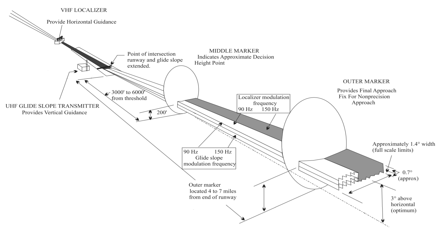
English: FAA Instrument Landing Systems |
| التاريخ | |
| المصدر | Aeronautical Information Manual, https://www.faa.gov/air_traffic/publications/media/AIM_Basic_dtd_10-12-17.pdf |
| المؤلف | U.S. Dept. of Transportation, Federal Aviation Administration, |
| إصدارات أخرى |


|
هذه transport map الصورة / الصورتان باستعمال رسومات متجهية ملفات رسوميات شعاعية.
It is recommended to name the SVG file "ILS diagramsimplified.svg" - then the template Vector version available (or Vva) does not need the new image name parameter.
|
ترخيص
This image or file is a work of a Federal Aviation Administration employee, taken or made as part of that person's official duties. As a work of the U.S. federal government, the image is in the public domain in the United States.
|
 |
تاريخ الملف
اضغط على زمن/تاريخ لرؤية الملف كما بدا في هذا الزمن.
| زمن/تاريخ | صورة مصغرة | الأبعاد | مستخدم | تعليق | |
|---|---|---|---|---|---|
| حالي | 13:14، 10 أكتوبر 2018 | | 1٬468 × 768 (102 كيلوبايت) | Marc Lacoste | simplified |
| 13:13، 10 أكتوبر 2018 |  | 1٬477 × 751 (484 كيلوبايت) | Marc Lacoste | File:ILS diagram.png cropped 4 % horizontally, 27 % vertically using CropTool with precise mode. |
استخدام الملف
الصفحة التالية تستخدم هذا الملف:
الاستخدام العالمي للملف
الويكيات الأخرى التالية تستخدم هذا الملف:
- الاستخدام في ca.wikipedia.org
- الاستخدام في en.wikipedia.org
- الاستخدام في es.wikipedia.org
- الاستخدام في fa.wikipedia.org
- الاستخدام في lv.wikipedia.org
- الاستخدام في tr.wikipedia.org
- الاستخدام في www.wikidata.org