ملف:East-Hem 1000bc.jpg
الملف الأصلي (3٬240 × 1٬903 بكسل حجم الملف: 1٫43 ميجابايت، نوع MIME: image/jpeg)
| هذا ملف من ويكيميديا كومنز. معلومات من صفحة وصفه مبينة في الأسفل. كومنز مستودع ملفات ميديا ذو رخصة حرة. |

|
هذه historical map الصورة / الصورتان باستعمال رسومات متجهية ملفات رسوميات شعاعية.
It is recommended to name the SVG file "East-Hem 1000bc.svg" - then the template Vector version available (or Vva) does not need the new image name parameter.
|


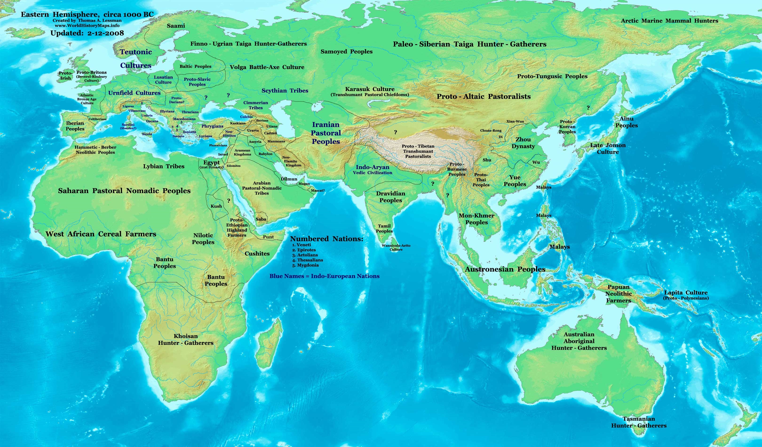
| الوصف | Eastern Hemisphere in 1000 BC. |
| المصدر | self-made (For reference information, see below) |
| المؤلف | Thomas Lessman (Contact!) |
| إصدارات أخرى | see East-Hem_1000bc.jpg file history on Wikipedia. |
ترخيص
- يحقُّ لك:
- مشاركة العمل – نسخ العمل وتوزيعه وبثُّه
- إعادة إنتاج العمل – تعديل العمل
- حسب الشروط التالية:
- نسب العمل إلى مُؤَلِّفه – يلزم نسب العمل إلى مُؤَلِّفه بشكل مناسب وتوفير رابط للرخصة وتحديد ما إذا أجريت تغييرات. بالإمكان القيام بذلك بأية طريقة معقولة، ولكن ليس بأية طريقة تشير إلى أن المرخِّص يوافقك على الاستعمال.
- الإلزام بترخيص المُشتقات بالمثل – إذا أعدت إنتاج المواد أو غيرت فيها، فيلزم أن تنشر مساهماتك المُشتقَّة عن الأصل تحت ترخيص الأصل نفسه أو تحت ترخيص مُتوافِقٍ معه.
Map Summary
Original Source URL: http://www.thomaslessman.com/History/images/East-Hem_1000bc.jpg.
This map of the Eastern Hemisphere in 1000 BC was created by Thomas Lessman, based on information from the sources listed below. This map is free for educational use (see Permission info above). When using this map, please mention that it is available for free at www.WorldHistoryMaps.info.
Map Source References
- Remember, sources often conflict with each other. This map is only as accurate as the information that is available to me. To report any errors or to help further this work, please click here, or email Thomas Lessman at talessman@yis.us
References for information contained in this map:
1. Some info derive from the map of the World 1000 BCE, created by User:Briangotts..
2. Zhou (China) borders derive partially from the Huhai.net map of China: 11th to 9th centuries BC.
3. Some information derives from DK Atlas of World History, 2000 edition.
4. Other information is based on various Wikipedia articles and google searches dealing with nations depicted in this map.
Other Maps by Thomas Lessman
| Maps of the eastern hemisphere showing history
Bold dates are available on Wikimedia or Wikipedia. | ||
| Primeval | ||
| Ancient
|
·| 600 BC | 550 BC | 527 BC | 500 BC |
400 BC | ·| 1 AD | 50 AD | 100 AD | 200 AD | 300 AD | | |
| Medieval |
·| 500 AD | 565 AD | 600 AD | 700 AD | | |
| Modern |
·| 1500 AD | · * For historical maps of the whole world, | |
| الشروح | هذه الصورة مشروحة: أظهر الشروح في كومنز |


تاريخ الملف
اضغط على زمن/تاريخ لرؤية الملف كما بدا في هذا الزمن.
| زمن/تاريخ | صورة مصغرة | الأبعاد | مستخدم | تعليق | |
|---|---|---|---|---|---|
| حالي | 11:13، 28 سبتمبر 2023 | | 3٬240 × 1٬903 (1٫43 ميجابايت) | Notradeuussrs | added Punt |
| 07:15، 9 مايو 2008 |  | 3٬240 × 1٬903 (720 كيلوبايت) | Talessman | {{Information |Description='''Eastern Hemisphere in 1000 BC'''. |Source=self-made (For reference information, see below) |Author=Thomas Lessman (Contact!) |Date= |Location= |Permission={{self|cc-by-sa-3.0}} |othe |
استخدام الملف
الصفحة التالية تستخدم هذا الملف:
الاستخدام العالمي للملف
الويكيات الأخرى التالية تستخدم هذا الملف:
- الاستخدام في en.wikipedia.org
- الاستخدام في gl.wikipedia.org
- الاستخدام في hy.wikipedia.org
- الاستخدام في hyw.wikipedia.org
- الاستخدام في ro.wikipedia.org
- الاستخدام في sv.wikipedia.org
- الاستخدام في tr.wikipedia.org