ملف:Cambridgeshire outline map with UK.png

حجم هذه المعاينة: 504 × 600 بكسل. البعدان الآخران: 202 × 240 بكسل | 600 × 714 بكسل.
الملف الأصلي (600 × 714 بكسل حجم الملف: 342 كيلوبايت، نوع MIME: image/png)
| هذا ملف من ويكيميديا كومنز. معلومات من صفحة وصفه مبينة في الأسفل. كومنز مستودع ملفات ميديا ذو رخصة حرة. |
ملخص
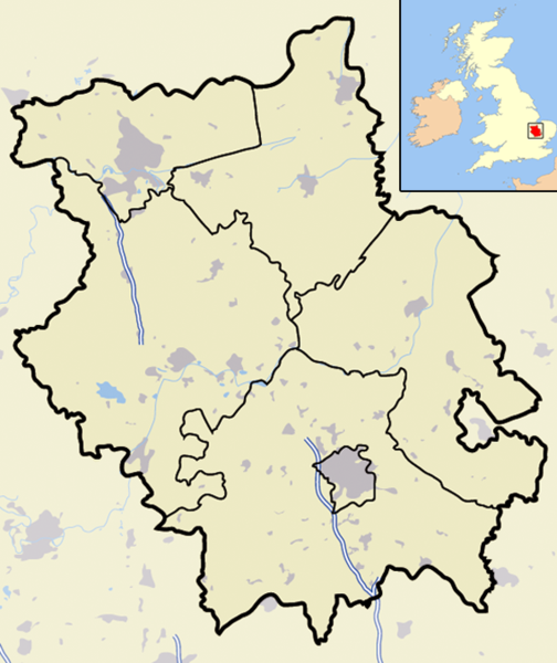
| الوصف | A map of the ceremonial county of Cambridgeshire, in the East of England. Appended to the top right is a mini map of the British Isles with Cambridgeshire's location and relative size marked in red. On the main map rural areas are in yellow; urban areas are in grey; district and county boundaries are in black; bodies of water are in light blue; motorways are in dark blue with a white stripe. |
| التاريخ | |
| المصدر | Completely self-made, but boundaries and features can be verified via a variety of sources including (but not exclusive to) the Fifth periodical report - Volume 3 Mapping for the London Boroughs and the Metropolitan Counties by the Boundary Commission for England. |
| المؤلف | Jhamez84 |
| الترخيص (إعادة استخدام هذا الملف) |
عمل شخصي |
| إصدارات أخرى |
أَعمالٌ مُشتقَّة مِن هذا الملفِّ: |
ترخيص
| أنا، مالِك حقوق تأليف ونشر هذا العمل، أجعله في النِّطاق العامِّ، يسري هذا في أرجاء العالم كلِّه. في بعض البلدان، قد يكون هذا التَّرخيص غيرَ مُمكنٍ قانونيَّاً، في هذه الحالة: أمنح الجميع حق استخدام هذا العمل لأي غرض دون أي شرط ما لم يفرض القانون شروطًا إضافية. |
تاريخ الملف
اضغط على زمن/تاريخ لرؤية الملف كما بدا في هذا الزمن.
| زمن/تاريخ | صورة مصغرة | الأبعاد | مستخدم | تعليق | |
|---|---|---|---|---|---|
| حالي | 00:01، 23 نوفمبر 2007 | | 600 × 714 (342 كيلوبايت) | Jza84 | {{Information |Description=Map of the County of Cambridgeshire, England, United Kingdom |Source=self-made |Date=November 2007 |Author= Jhamez84 |Permission=See below |other_versions= }} |
استخدام الملف
الصفحة التالية تستخدم هذا الملف:
الاستخدام العالمي للملف
الويكيات الأخرى التالية تستخدم هذا الملف:
- الاستخدام في arz.wikipedia.org
- الاستخدام في ceb.wikipedia.org
- الاستخدام في en.wikipedia.org
- الاستخدام في fr.wikipedia.org
- الاستخدام في ml.wikipedia.org
- الاستخدام في ro.wikipedia.org
- الاستخدام في sv.wikipedia.org
- الاستخدام في www.wikidata.org