ملف:Balearic Sea map.png
حجم هذه المعاينة: 800 × 511 بكسل. الأبعاد الأخرى: 320 × 204 بكسل | 640 × 409 بكسل | 1٬000 × 639 بكسل.
الملف الأصلي (1٬000 × 639 بكسل حجم الملف: 77 كيلوبايت، نوع MIME: image/png)
| هذا ملف من ويكيميديا كومنز. معلومات من صفحة وصفه مبينة في الأسفل. كومنز مستودع ملفات ميديا ذو رخصة حرة. |
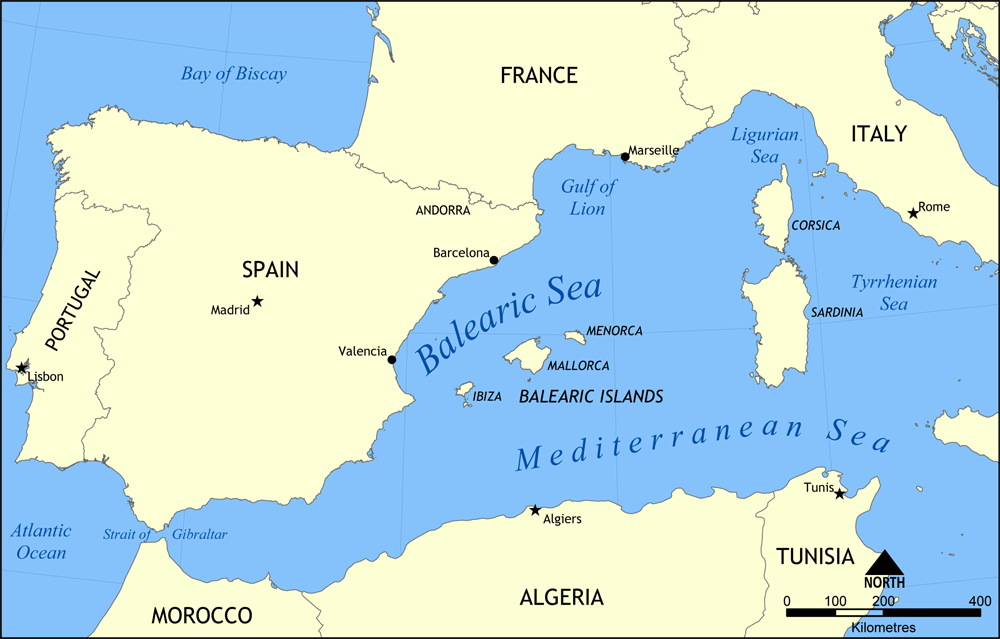
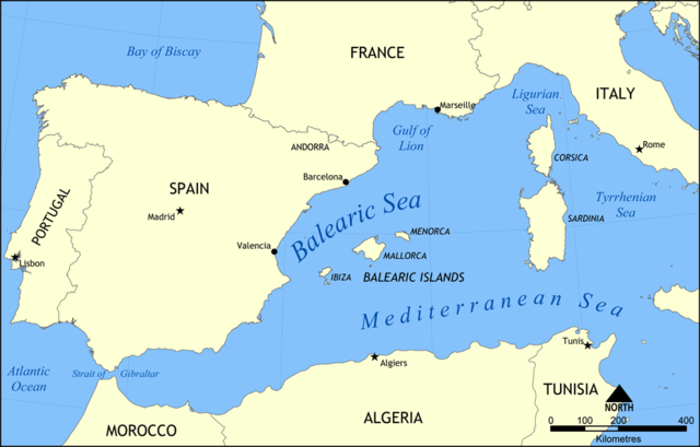
Map showing the location of the Balearic Sea, part of the Mediterranean Sea.
Created by NormanEinstein, May 26, 2006.
أنا، صاحب حقوق التأليف والنشر لهذا العمل، أنشر هذا العمل تحت الرخصة التالية:

|
يسمح نسخ وتوزيع و/أو تعديل هذه الوثيقة تحت شروط رخصة جنو للوثائق الحرة، الإصدار 1.2 أو أي إصدار لاحق تنشره مؤسسة البرمجيات الحرة؛ دون أقسام ثابتة ودون نصوص أغلفة أمامية ودون نصوص أغلفة خلفية. نسخة من الرخصة تم تضمينها في القسم المسمى GNU Free Documentation License. |
| هذا الملفُّ مُرخَّص بموجب رخصة المشاع الإبداعي نسبة المُصنَّف إِلى مُؤَلِّفه - المشاركة بالمثل 3.0 العامة | ||
| ||
| تمت إضافة علامة الترخيص لهذا الملف كجزء من رخصة جنو للوثائق الحرة تحديث الترخيص. |
تاريخ الملف
اضغط على زمن/تاريخ لرؤية الملف كما بدا في هذا الزمن.
| زمن/تاريخ | صورة مصغرة | الأبعاد | مستخدم | تعليق | |
|---|---|---|---|---|---|
| حالي | 15:31، 26 مايو 2006 | | 1٬000 × 639 (77 كيلوبايت) | NormanEinstein | Map showing the location of the Balearic Sea, part of the Mediterranean Sea. Created by NormanEinstein, May 26, 2006. {{GFDL-self}} Category:Maps of seas |
استخدام الملف
لا توجد صفحات تستخدم هذا الملف.
الاستخدام العالمي للملف
الويكيات الأخرى التالية تستخدم هذا الملف:
- الاستخدام في af.wikipedia.org
- الاستخدام في an.wikipedia.org
- الاستخدام في avk.wikipedia.org
- الاستخدام في az.wikipedia.org
- الاستخدام في az.wiktionary.org
- الاستخدام في be.wikipedia.org
- الاستخدام في bg.wikipedia.org
- الاستخدام في bn.wikipedia.org
- الاستخدام في bs.wikipedia.org
- الاستخدام في ca.wikipedia.org
- الاستخدام في ce.wikipedia.org
- الاستخدام في ckb.wikipedia.org
- الاستخدام في cv.wikipedia.org
- الاستخدام في da.wikipedia.org
- الاستخدام في en.wikipedia.org
- HMS Nelson (28)
- French battleship Bouvet
- Balearic Sea
- Malta convoys
- User:NormanEinstein/gallery
- French ironclad Dévastation
- French battleship Mirabeau
- French battleship Justice
- French battleship Vérité
- French battleship République
- French battleship Patrie
- French ironclad Magenta (1890)
- French battleship Charles Martel
- French battleship Brennus
- French ironclad Marceau
- French ironclad Neptune
- French cruiser Lavoisier
- French cruiser Troude
- Action of 19 February 1801
- User talk:Keith-264/sandbox5
- French cruiser Milan
- French cruiser Tage
- French cruiser Sfax
- French cruiser Forbin
- French cruiser Lalande
- French cruiser Cosmao
- French cruiser Cassard
- French cruiser Du Chayla
- French cruiser D'Iberville
- French cruiser Casabianca
- الاستخدام في es.wikipedia.org
اعرض المزيد من الاستخدام العام لهذا الملف.