ملف:1865 Spruner Map Israel or Palestine post 70 AD.jpg
حجم هذه المعاينة: 372 × 599 بكسل. الأبعاد الأخرى: 149 × 240 بكسل | 298 × 480 بكسل | 476 × 768 بكسل | 635 × 1٬024 بكسل | 1٬353 × 2٬180 بكسل.
الملف الأصلي (1٬353 × 2٬180 بكسل حجم الملف: 1٫39 ميجابايت، نوع MIME: image/jpeg)
| هذا ملف من ويكيميديا كومنز. معلومات من صفحة وصفه مبينة في الأسفل. كومنز مستودع ملفات ميديا ذو رخصة حرة. |
ملخص
| المؤلف |
|
||
| الوصف |
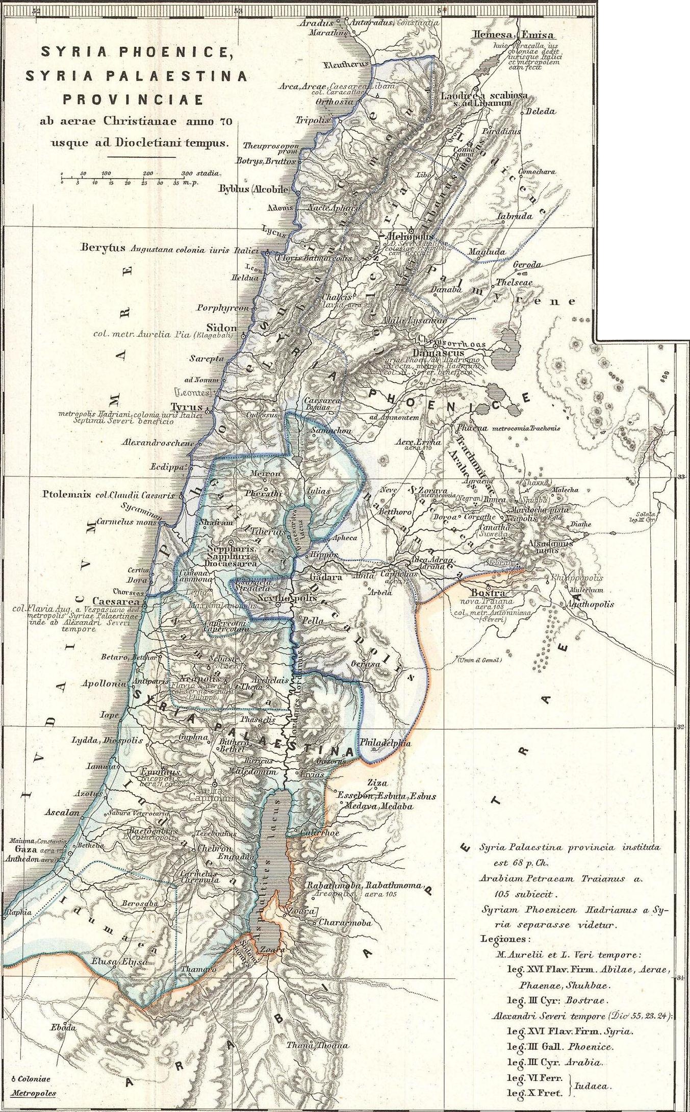
English: This is Karl von Spruner’s 1865 map of the Holy Land, or Israel and Palestine. Essentially nine maps in one, Spruner features two dominant maps and 7 smaller insets, including a Peutinger Table in the lower-right quadrant. The Peutinger Map is an astoundingly important discovery and is today’s only known example of a Roman world map, though the original Peutinger was itself a mediaeval copy of the Roman original. This map also shows, in counter-clock wise order from the Peutinger table, Galilaea, Hierosolyma, Judaea, Palestine at the time of Herod, Syria, Arabia, and Phoeniciae, Palestine, and Arabia. Many of the insets include their own scale or legend. Map notes important cities, rivers, mountain ranges and other minor topographical detail. Territories and countries outlined in color. The whole is rendered in finely engraved detail exhibiting throughout the fine craftsmanship of the Perthes firm. |
||
| التاريخ | ١٨٦٥ (undated) | ||
| الأبعاد | ارتفاع: ١٦٫٠ إنش (٤٠٫٦ سم)؛ عرض: ١٣٫٠ إنش (٣٣٫٠ سم) | ||
| رقم التصنيف |
وصلة موقع جيوغرافيكوس: Phoenice-spruner-1865 |
||
| المصدر/المصور |
هذا الملفُّ مُشتقٌ مِن: 1865 Spruner Map of the Holy Land, Israel, or Palestine in Antiquity - Geographicus - Phoenice-spruner-1865.jpg: |
| هذا رسمٌ مُعَدَّلٌ رقميَّاً من النسخة الأصليَّة. التعديلات هي: Map divided into 2/3 parts (maps). يُمكن الاطلاع على النسخة الأصليَّة هنا: 1865 Spruner Map of the Holy Land, Israel, or Palestine in Antiquity - Geographicus - Phoenice-spruner-1865.jpg:
|
ترخيص
|
هذه الصورة هي إعادة إنتاج خالصة لعمل فني ثنائي الأبعاد وبالتالي فلا يمكن أن يكون لها حقوق نشر وتأليف بنفسها في الولايات المتحدة حسب قضية مكتبة فنون بريدجمان ضد شركة كورل؛ المسألة قانونية أيضاً في العديد من الدول الأخرى، بما في ذلك ألمانيا.
العمل الأصلي ثنائي الأبعاد المعروض في هذه الصورة هو محتوى حر بسبب:
لذا فإنَّ إعادة الإنتاج هذه تخضع أيضاً لنفس الشروط كما هو الحال مع العمل الأصلي.
| ||||
سجلُّ الرَّفع الأصيل
This image is a derivative work of the following images:
- File:1865_Spruner_Map_of_the_Holy_Land,_Israel,_or_Palestine_in_Antiquity_-_Geographicus_-_Phoenice-spruner-1865.jpg licensed with PD-Art
- 2011-03-25T05:57:05Z BotMultichillT 3500x2897 (2712725 Bytes) {{subst:User:Multichill/Geographicus |link=http://www.geographicus.com/P/AntiqueMap/Phoenice-spruner-1865 |product_name=1865 Spruner Map of the Holy Land, Israel, or Palestine in Antiquity |map_title=Phoenice, Coelesyria, Dec
Uploaded with derivativeFX
تاريخ الملف
اضغط على زمن/تاريخ لرؤية الملف كما بدا في هذا الزمن.
| زمن/تاريخ | صورة مصغرة | الأبعاد | مستخدم | تعليق | |
|---|---|---|---|---|---|
| حالي | 08:29، 10 يناير 2013 | | 1٬353 × 2٬180 (1٫39 ميجابايت) | Cristiano64 | == {{int:filedesc}} == {{Information |Description={{en|This is Karl von Spruner’s 1865 map of the Holy Land, or Israel and Palestine. Essentially nine maps in one, Spruner features two dominant maps and 7 smaller insets, including a Peutinger Table ... |
استخدام الملف
الصفحة التالية تستخدم هذا الملف:
الاستخدام العالمي للملف
الويكيات الأخرى التالية تستخدم هذا الملف:
- الاستخدام في en.wikipedia.org
- الاستخدام في eo.wikipedia.org
- الاستخدام في it.wikipedia.org
- الاستخدام في mk.wikipedia.org
- الاستخدام في mt.wikipedia.org
- الاستخدام في ru.wikipedia.org
- الاستخدام في zh.wikipedia.org