ملف:1771 Bonne Map of the Mediterranean and the Maghreb or Barbary Coast - Geographicus - Barbarie-bonne-1771.jpg

حجم هذه المعاينة: 800 × 561 بكسل. الأبعاد الأخرى: 320 × 224 بكسل | 640 × 449 بكسل | 1٬024 × 718 بكسل | 1٬280 × 897 بكسل | 2٬560 × 1٬795 بكسل | 3٬500 × 2٬454 بكسل.
الملف الأصلي (3٬500 × 2٬454 بكسل حجم الملف: 2٫22 ميجابايت، نوع MIME: image/jpeg)
| هذا ملف من ويكيميديا كومنز. معلومات من صفحة وصفه مبينة في الأسفل. كومنز مستودع ملفات ميديا ذو رخصة حرة. |
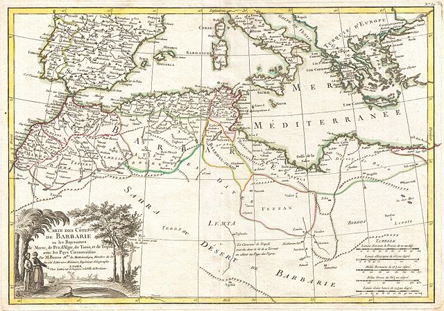
| Rigobert Bonne: Carte des Cotes de Barbarie ou Les Royaumes de Marco, de Fez, d'Alger, de Tunis, et de Tripoli avec les Pays Circonvoisins.
( |
|||||||||||||||||||||||
|---|---|---|---|---|---|---|---|---|---|---|---|---|---|---|---|---|---|---|---|---|---|---|---|
| الفنان |
|
||||||||||||||||||||||
| العنوان |
Carte des Cotes de Barbarie ou Les Royaumes de Marco, de Fez, d'Alger, de Tunis, et de Tripoli avec les Pays Circonvoisins. |
||||||||||||||||||||||
| الوصف |
English: A beautiful example of Rigobert Bonne's decorative map of the Maghreb or Barbary Coast. Covers northwestern Africa and the western Mediterranean. This region, known since the days of Columbus as Tierra Firma, consists of the modern day nations of Tunisia, Libya, Algeria and Morocco. Offers excellent detail throughout showing mountains, rivers, national boundaries, cities, regions, and tribes. As Bonne was preparing this map, the Barbary Coast was a hotbed of piracy - much like the Somali coast today. The Barbary Pirates would attack trading ships passing through the narrow Gibraltar straits and western Mediterranean. Ships would be destroyed or appropriated, cargo sized, and the crews and passengers enslaved. By the early 19th century, piracy in this region had become so intense that the United States launched its first major naval offensive against Tripoli. The resultant 1805 Battle of Derne later inspired a portion of the lyrics of the Marines' Hymn , the shores of Tripoli. A large decorative title cartouche appears in the lower left quadrant. Drawn by R. Bonne in 1771 for issue as plate no. 30 in Jean Lattre's 1776 issue of the Atlas Moderne . |
||||||||||||||||||||||
| التاريخ | ١٧٧١ (undated) | ||||||||||||||||||||||
| الأبعاد | ارتفاع: ١٣٫٠ إنش (٣٣٫٠ سم)؛ عرض: ١٧٫٥ إنش (٤٤٫٤ سم) | ||||||||||||||||||||||
| رقم التصنيف |
وصلة موقع جيوغرافيكوس: Barbarie-bonne-1771 |
||||||||||||||||||||||
| المصدر/المصور |
Lattre, Jean, Atlas Moderne ou Collection de Cartes sur Toutes les Parties du Globe Terrestre, c. 1775.
|
||||||||||||||||||||||
| الترخيص (إعادة استخدام هذا الملف) |
|
||||||||||||||||||||||
| إصدارات أخرى | |||||||||||||||||||||||
.jpg)
تاريخ الملف
اضغط على زمن/تاريخ لرؤية الملف كما بدا في هذا الزمن.
| زمن/تاريخ | صورة مصغرة | الأبعاد | مستخدم | تعليق | |
|---|---|---|---|---|---|
| حالي | 17:33، 23 مارس 2011 | | 3٬500 × 2٬454 (2٫22 ميجابايت) | BotMultichillT | {{subst:User:Multichill/Geographicus |link=http://www.geographicus.com/P/AntiqueMap/Barbarie-bonne-1771 |product_name=1771 Bonne Map of the Mediterranean and the Maghreb or Barbary Coast |map_title=Carte des Cotes de Barbarie ou Les Royaumes de Marco, de |
استخدام الملف
ال7 صفحات التالية تستخدم هذا الملف:
الاستخدام العالمي للملف
الويكيات الأخرى التالية تستخدم هذا الملف:
- الاستخدام في en.wikipedia.org