ملف:1724 De L'Isle Map of Persia (Iran, Iraq, Afghanistan) - Geographicus - Persia-delisle-1724.jpg
الملف الأصلي(4٬500 × 3٬553 بكسل حجم الملف: 5٫58 ميجابايت، نوع MIME: image/jpeg)

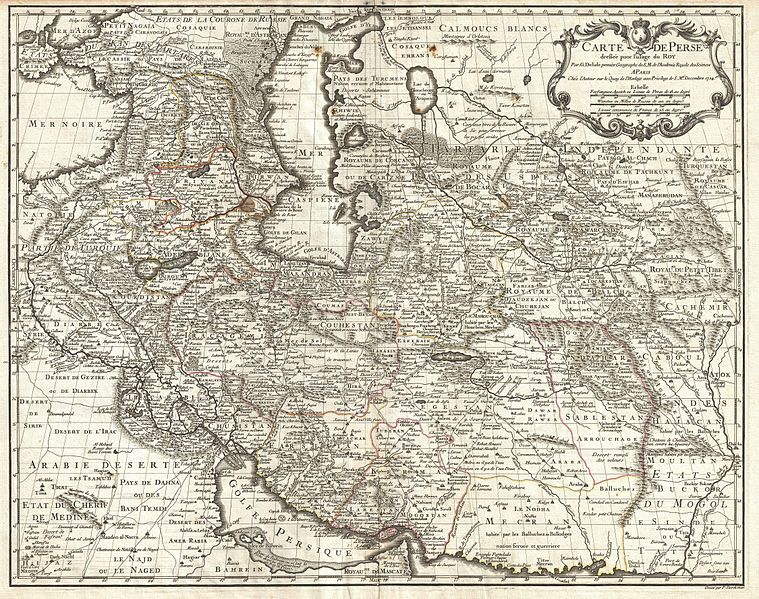
Carte de Perse, dressee pour l'usage du Roy. Par G. Delisle premier Geographe de S.M. de l'Academie Royale des Sciences.
الفنان
Guillaume Delisle
العنوان
Carte de Perse, dressee pour l'usage du Roy. Par G. Delisle premier Geographe de S.M. de l'Academie Royale des Sciences.
الوصف
English: A fine first edition example of Guillaume De L’Isle’s important 1724 map of Persia. Covers from the Crimea and the Sea of Azov south to the Persian Gulf and the Straight of Ormuz and east as far as Kashmir (Cachmir) and Kabul (Caboul). This map includes modern day Iran, Iraq, Afghanistan, Kuwait, Uzbekistan, Turkmenistan, Tajikistan, Georgia, Armenia, and Azerbaijan, with adjacent parts of Russia, Pakistan, Turkey, Ukraine, and Kazakhstan, and Arabia. Cartographically De L’Isle’s mapping of Persia marks a significant advance in European cartographic knowledge of the region. This map benefits considerably from Russian cartographic surveys and other sources no doubt smuggled to Guillaume De L’Isle by his brother Nicholas de L’Isle, who held a cartographic position with the Russian Academy of Sciences. The extent to which Russian data influenced this map is nowhere more evident than in De L’Isle’s remarkable rendering of the Caspian Sea – one of the first accurate maps of the great lake to follow Van Verden’s historic survey of 1721. Russian cartographic information is also apparent with regard to place names, such as the Russian name for the Aral Sea (Glouchoiye). It is equally likely that De L’Isle drew on Russian sources for his mapping of the Silk Route centers of Bukhara, Samarkand, and Ferghana, which were known stopping points for Russian trade envoys to China. For the remainder of Persia De L’Isle most likely updated Persian and Arabic cartographic information with reports from Georgian and Armenian traders and mercenaries active throughout Persia. It may be through these sources that De L’Isle was able to add considerable geographic information regarding trade routes and place names in central Persia. These include such significant advances as the identification of Terheran (Tiheran), the current capital of Iran, which is notable absent it earlier European maps of Persia. This map was drawn by Guillaume De L’Isle and engraved by P. Starckman. It issued independently as well as included in a number of composite atlases including De L’Isle’s 1731 Atlas de Geographie . A number of reissues by Buache, Covens & Mortier, and others followed.
التاريخ ١٧٢٤ (undated)
الأبعاد ارتفاع: ٢٠٫٠ إنش (٥٠٫٨ سم)؛ عرض: ٢٥٫٠ إنش (٦٣٫٥ سم)
dimensions QS:P2048,20U218593
dimensions QS:P2049,25U218593
رقم التصنيف
وصلة موقع جيوغرافيكوس: Persia-delisle-1724
المصدر/المصور

De L'Isle, G., Atlas de Geographie, c. 1730.

الترخيص
(إعادة استخدام هذا الملف)
هذه الصورة هي إعادة إنتاج خالصة لعمل فني ثنائي الأبعاد وبالتالي فلا يمكن أن يكون لها حقوق نشر وتأليف بنفسها في الولايات المتحدة حسب قضية مكتبة فنون بريدجمان ضد شركة كورل؛ المسألة قانونية أيضاً في العديد من الدول الأخرى، بما في ذلك ألمانيا.
العمل الأصلي ثنائي الأبعاد المعروض في هذه الصورة هو محتوى حر بسبب:
Public domain

هذا العمل يقع في النَّطاق العامّ في بلد المنشأ وفي البلدان الأخرى والمناطق التي تمتدُّ فيها مدة حقوق التَّأليف والنشر لتغطي زمن حياة المُؤلِّف و 100 سنةً بعد وفاته أو أقل من ذلك.


أنتَ أيضاً مُلزمٌ بتضمين وسم النَّطاق العامّ لتحديد السبب الَّذي يجعلُ من هذا العمل مِلكيَّةً عامةً في الولايات المُتحدة الأمريكيَّة
لذا فإنَّ إعادة الإنتاج هذه تخضع أيضاً لنفس الشروط كما هو الحال مع العمل الأصلي.
إصدارات أخرى

ويكيبيديا

 هذه الصُّورة مُختارةٌ على ويكيبيديا الفارسية (نگاره‌های برگزیده) و مُرشَّحة لتَكُون إحدى أَفضل الصُّور.

إِذا كُنت تَعتَقِد بأَنَّ هذه الصُّورة يجب أَن تَكُون صُورةً مُختارةً على وِيكيميديا كُومِنز، رشِّحها!.
إذا كان لديك صُورةٌ ذاتُ جُودةٍ مُماثِلةٍ، فمِن المُمكِن نَشرُها تحت رُخصة مُناسِبة، ارفعها، وأَضف وسوم حقوق التَّأليف والنَّشر إِليها، ثُمَّ رشِّحها.

الشروحات

أضف شرحاً من سطر واحد لما يُمثِّله هذا الملف

العناصر المصورة في هذا الملف

يُصوِّر

c369fa4e5652c19538b14f2755a70d576ca52710

طريقة الاستدلال: SHA-1 الإنجليزية

٥٬٨٥٥٬٧٧١ بايت

٣٬٥٥٣ بكسل

٤٬٥٠٠ بكسل

تاريخ الملف

اضغط على زمن/تاريخ لرؤية الملف كما بدا في هذا الزمن.

زمن/تاريخصورة مصغرةالأبعادمستخدمتعليق
حالي03:53، 25 مارس 2011تصغير للنسخة بتاريخ 03:53، 25 مارس 20114٬500 × 3٬553 (5٫58 ميجابايت)BotMultichillT{{subst:User:Multichill/Geographicus |link=http://www.geographicus.com/P/AntiqueMap/Persia-delisle-1724 |product_name=1724 De L'Isle Map of Persia (Iran, Iraq, Afghanistan) |map_title=Carte de Perse, dressee pour l'usage du Roy. Par G. Delisle premier Geo

الصفحتان التاليتان تستخدمان هذا الملف:

الاستخدام العالمي للملف

الويكيات الأخرى التالية تستخدم هذا الملف: